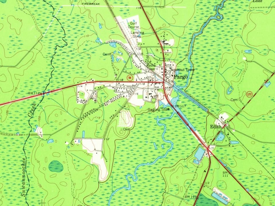
Most of Fargo was built recently: 2% of its homes predate 1940 and the median home dates from 1975. Below: maps from 1967 on and the census since 2000.
Wikipedia doesn’t have a history of Fargo yet. The photos, dates and memories neighbors add here are how it gets written.
Fargo is a city in Clinch County, Georgia, United States. As of the 2020 census, the city had a population of 250. Formerly a town, it was incorporated by the Georgia state legislature in 1992, effective from April 1. Fargo is one of the most remote cities in Georgia, with the only settlement in almost 20 miles being Williamsburg. Fargo is located near the Okefenokee Swamp and is the western gateway to the Okefenokee National Wildlife Refuge. Also nearby is Stephen C. Foster State Park. The Bugaboo Fire threatened the city in April and May 2007.
Its first post office opened in 1898. Between the 2010 and 2020 censuses its population fell from 321 to 250 (-22%).
Intro from Wikipedia. Population: U.S. Census Bureau.
From the old history books
What they wrote about Fargo in 1916
Passages that mention Fargo, cut from the printed page as they were published.
History of Clinch County, Georgia, revised to date, giving the early history of the county down to the present time (1916)1916 · page 85Read the page →
Read the text
The town of Fargo was laid out on the banks of the Suwannee River, and is to-day one of the most flourishing towns in the county. It has several stores, a large hotel and other
Text read by machine from the scan; it may contain errors.
History of Clinch County, Georgia, revised to date, giving the early history of the county down to the present time (1916)1916 · page 86Read the page →
Read the text
Within a very short time another large saw-mill was put up six miles East of Fargo, on the new railroad, by the American Manufacturing Company, a corporation. Their mills are about as large as the Fargo plant. The place was called "Council," in honor of the principal owners of the mill, John M. and C. M. Council, of Americus, Ga.
Text read by machine from the scan; it may contain errors.
Scans and text from the Internet Archive. Books published in 1930 or earlier, which are in the public domain.
Timeline
Fargo, 1898 to 1987
Woven from the archive, old maps, post office records, the National Register and the people born here.
Founding dates: Wikidata, Wikipedia, the U.S. post office records of Blevins & Helbock (CC0) and the Census. Homes by year built: Census ACS 2020–24. National Register of Historic Places: National Park Service (list of May 22, 2026). Old photos, postcards and papers: Wikimedia Commons, the Library of Congress and other public archives, credited on each item’s page. Maps: U.S. Geological Survey historical topographic maps (via Esri) and Sanborn fire-insurance maps (Library of Congress). History text and census tables: Wikipedia (CC BY-SA 4.0). Places that used to be: USGS Geographic Names Information System (2021). How TownRatings grades history →
From Wikimedia Commons (12), Wikidata and Wikipedia for famous people, U.S. Geological Survey historical maps, U.S. Census counts (via Wikipedia), the US Post Offices dataset (Blevins & Helbock), the USGS Geographic Names Information System and old county and town histories (Internet Archive). Archive images are copied here with their credits and licenses, shown on each photo’s page. Refreshed monthly.


 2014
 2014
 2014
 2014
 2014
 2014
 2014
 2014
 2014
 2014
 2014
 2012