
Château de Voisins: Saint-Hilarion’s one place to visit
4 of the 7 places to visit in and around Saint-Hilarion are châteaux or heritage sites. One place to visit is mapped in Saint-Hilarion, with 6 more within 5 km of its centre. In town, one site is a listed historic monument. Further afield, Château de Versailles is 36 km from the centre.
Start with these in Saint-Hilarion
Château de Voisins aside, the next best known are 2 museums, an abbey and a château.
 AbbeyPrieuré Saint-Thomas d'Épernon3.5 km west, in Épernon
 MuseumConservatoire des meules et pavés du bassin d'Épernon3.6 km west, in ÉpernonChâteauChâteauChâteau de Sauvage3.7 km southeast, in ÉmancéHistoric houseHistoric houseMaison du mathématicien Michel Chasles3.2 km west, in ÉpernonMuseumMuseumMusée des meules et pavés3.6 km west, in Épernon
Best known first: by how many Wikipedia and sister-site articles cover each place (Wikidata’s count). It isn’t a ranking of how good they are.
Where things are
To the west is where most of the 6 lie.
The first 20 on the list, numbered as below. The shape is the commune of Saint-Hilarion; the orange dot is its centre. © OpenStreetMap contributors · commune boundary: IGN
By kind
Ahead are châteaux or heritage sites (4); next, museums or galleries (2).
Dark: in Saint-Hilarion. Light: in the communes within 5 km of its centre.
The full list
The town has one; within 5 km of its centre, the list finds 6 more.
The one place in Saint-Hilarion, then those within 5 km of its centre.
The history of Saint-Hilarion → · Parks and trails in Saint-Hilarion →
Bigger names, a drive away
The standout of the 12 is Château de Versailles, 36 km from town.
 AttractionChâteau de Versailles36 km northeast, in Versailles
 AttractionCathédrale Notre-Dame de Chartres25 km southwest, in Chartres
 MuseumChâteau de Rambouillet7.9 km northeast, in Rambouillet
 AttractionPetit Trianon36 km northeast, in VersaillesAttractionAttractionAbbaye de Port-Royal-des-Champs à Magny-les-Hameaux26 km northeast, in Magny-les-Hameaux
 ChâteauChâteau de Maintenon11 km west, in Maintenon
 AttractionGrand Trianon36 km northeast, in Versailles
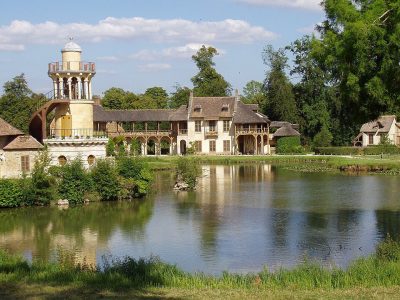 AttractionHameau de la Reine37 km northeast, in VersaillesCathedralCathedralCathédrale Saint-Louis de Versailles36 km northeast, in Versailles
 GardenJardin de Versailles36 km northeast, in Versailles
 ChâteauChâteau d'Anet34 km northwest, in AnetChâteauChâteauChâteau de Dampierre22 km northeast, in Dampierre-en-Yvelines
Places within 40 km of Saint-Hilarion with an article in both French and English Wikipedia, nearest first.
Seeing Saint-Hilarion: your questions
What is there to see in Saint-Hilarion?
The one place mapped in Saint-Hilarion is Château de Voisins. We list 1 place in town. Another 6 are within 5 km of the centre.
Are there museums in or near Saint-Hilarion?
2 museums and galleries in town or within 5 km, including Conservatoire des meules et pavés du bassin d'Épernon and Musée des meules et pavés.
Which places in Saint-Hilarion are listed historic monuments?
One place on this page in Saint-Hilarion is a listed or registered historic monument (Mérimée): Château de Voisins.
What well-known places are within a day out of Saint-Hilarion?
The nearest with articles in both French and English Wikipedia: Château de Versailles (36 km), Cathédrale Notre-Dame de Chartres (25 km), Château de Rambouillet (7.9 km), Petit Trianon (36 km).
How is this list made?
From OpenStreetMap and Wikidata: named museums, galleries, châteaux, abbeys, gardens, zoos, theme parks and other visitor attractions whose mapped point lies inside the commune of Saint-Hilarion, then those in the communes within 5 km of its centre, and well-known places within 40 km. Houses, ruins and gardens need a sign they’re open to visitors; places marked private, closed or disused are left out. The historic-monument link is the Culture ministry’s Mérimée record. A place that isn’t mapped isn’t listed, so this isn’t everything there is to see.
Sources: OpenStreetMap (© OpenStreetMap contributors, ODbL), Wikidata (CC0: descriptions, websites, Wikipedia articles), the Culture ministry’s Mérimée database (Licence Ouverte 2.0), IGN commune boundaries. Distances are from the commune’s centre point.
Photos from Wikimedia Commons, each under its own licence (our copy, resized).
Photo credits (11)
- Prieuré Saint-Thomas d'Épernon: Athena Atterdag, CC BY-SA 4.0, Wikimedia Commons
- Conservatoire des meules et pavés du bassin d'Épernon: nicolas Leclerc, CC BY-SA 3.0, Wikimedia Commons
- Château de Versailles: ToucanWings, CC BY-SA 3.0, Wikimedia Commons
- Cathédrale Notre-Dame de Chartres: BT, Public domain, Wikimedia Commons
- Château de Rambouillet: Pline, CC BY-SA 3.0, Wikimedia Commons
- Petit Trianon: KimonBerlin, CC BY-SA 2.0, Wikimedia Commons
- Château de Maintenon: Eric Pouhier, CC BY-SA 4.0, Wikimedia Commons
- Grand Trianon: Lionel Allorge, CC BY-SA 3.0, Wikimedia Commons
- Hameau de la Reine: Daderot, CC BY-SA 3.0, Wikimedia Commons
- Jardin de Versailles: Anonymous Unknown author, Public domain, Wikimedia Commons
- Château d'Anet: audinou, CC BY 2.0, Wikimedia Commons
Contains public sector information under the Licence Ouverte / Open Licence 2.0 (Etalab): INSEE, DGFiP, the Interior Ministry’s statistics service (SSMSI), the Ministry of Education (DEPP), the Health Ministry’s statistics service (DREES) and the Housing Ministry (Carte des loyers). Commune boundaries: IGN Admin Express.