
Seeing Saint-Samson-sur-Rance? Begin at Manoir du Châtelier-Guitrel
21 of the 34 places to visit in and around Saint-Samson-sur-Rance are châteaux or heritage sites. Look within 5 km of its centre and the list grows by 31 beyond the 3 in Saint-Samson-sur-Rance. The town’s list includes one listed historic monument. Further afield lies Cathédrale Saint-Vincent de Saint-Malo, at 18 km.
What Saint-Samson-sur-Rance is known for
The rest of the best known are 2 châteaux, a museum and an archaeological site.
 Archaeological siteAllée couverte de Bel Evan4.1 km north, in Plouër-sur-RanceMonastery or conventMonastery or conventCouvent des Cordeliers de Dinan4.5 km southwest, in Dinan
Best known first: by how many Wikipedia and sister-site articles cover each place (Wikidata’s count). It isn’t a ranking of how good they are.
Around Saint-Samson-sur-Rance, mapped
At the edge of the map sits Château de Dinan, 4.9 km out.
The first 20 on the list, numbered as below. The shape is the commune of Saint-Samson-sur-Rance; the orange dot is its centre. © OpenStreetMap contributors · commune boundary: IGN
Kind by kind
Most are châteaux or heritage sites, 21 in all, ahead of museums or galleries (11).
Dark: in Saint-Samson-sur-Rance. Light: in the communes within 5 km of its centre.
All of them, one by one
First the 3 in town, then the 31 within 5 km of its centre.
Allée couverte de Bel Evan
Gallery grave in Plouër-sur-Rance, France.
Couvent des Cordeliers de Dinan
Convent located in Côtes-d'Armor, in France.
Couvent des Ursulines de Dinan
Convent located in Côtes-d'Armor, in France.
Couvent des Dominicaines de Dinan
Convent located in Côtes-d'Armor, in France.
The 3 places in Saint-Samson-sur-Rance first, then those within 5 km of its centre.
The history of Saint-Samson-sur-Rance → · Parks and trails in Saint-Samson-sur-Rance →
Around the region
Out of town, Cathédrale Saint-Vincent de Saint-Malo (18 km) leads 12 names to know.
 ChâteauChâteau de Combourg22 km southeast, in CombourgAttractionAttractionFort la Latte28 km northwest, in Plévenon
 AquariumGrand aquarium de Saint-Malo14 km north, in Saint-Malo
 FortFort National18 km north, in Saint-MaloChâteauChâteauChâteau de Saint-Malo18 km north, in Saint-MaloAttractionAttractionMenhir de Champ-Dolent21 km east, in Dol-de-BretagneFortFortFort du Petit Bé18 km north, in Saint-Malo
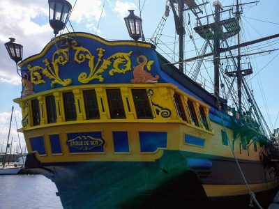 AttractionÉtoile du Roy18 km north, in Saint-MaloFortFortFort de la Conchée21 km north, in Saint-Malo
Places within 40 km of Saint-Samson-sur-Rance with an article in both French and English Wikipedia, nearest first.
Saint-Samson-sur-Rance: questions and answers
What is there to see in Saint-Samson-sur-Rance?
The first on our list in Saint-Samson-sur-Rance are Manoir du Châtelier-Guitrel, Château de la Tiemblais and Manoir du Carheil. We list 3 places in town. Another 31 are within 5 km of the centre.
Are there museums in or near Saint-Samson-sur-Rance?
11 museums and galleries in town or within 5 km, including Château de Dinan, Maison d'artiste de la Grande Vigne, Musée du château de Dinan and Le Moulin du Prat.
Which places in Saint-Samson-sur-Rance are listed historic monuments?
One place on this page in Saint-Samson-sur-Rance is a listed or registered historic monument (Mérimée): Manoir du Châtelier-Guitrel.
What well-known places are within a day out of Saint-Samson-sur-Rance?
The nearest with articles in both French and English Wikipedia: Cathédrale Saint-Vincent de Saint-Malo (18 km), Cathédrale Saint-Samson de Dol-de-Bretagne (21 km), Tour Solidor (16 km), Château de Combourg (22 km).
How is this list made?
From OpenStreetMap and Wikidata: named museums, galleries, châteaux, abbeys, gardens, zoos, theme parks and other visitor attractions whose mapped point lies inside the commune of Saint-Samson-sur-Rance, then those in the communes within 5 km of its centre, and well-known places within 40 km. Houses, ruins and gardens need a sign they’re open to visitors; places marked private, closed or disused are left out. The historic-monument link is the Culture ministry’s Mérimée record. A place that isn’t mapped isn’t listed, so this isn’t everything there is to see.
Sources: OpenStreetMap (© OpenStreetMap contributors, ODbL), Wikidata (CC0: descriptions, websites, Wikipedia articles), the Culture ministry’s Mérimée database (Licence Ouverte 2.0), IGN commune boundaries. Distances are from the commune’s centre point.
Photos from Wikimedia Commons, each under its own licence (our copy, resized).
Photo credits (5)
- Allée couverte de Bel Evan: Pymouss, CC BY-SA 4.0, Wikimedia Commons
- Château de Combourg: Calips, CC BY-SA 3.0, Wikimedia Commons
- Grand aquarium de Saint-Malo: MaxTab, CC BY 3.0, Wikimedia Commons
- Fort National: Pline, CC BY-SA 3.0, Wikimedia Commons
- Étoile du Roy: Proullon, CC BY-SA 4.0, Wikimedia Commons
Contains public sector information under the Licence Ouverte / Open Licence 2.0 (Etalab): INSEE, DGFiP, the Interior Ministry’s statistics service (SSMSI), the Ministry of Education (DEPP), the Health Ministry’s statistics service (DREES) and the Housing Ministry (Carte des loyers). Commune boundaries: IGN Admin Express.