
Fort National
You will find Fort National in Saint-Malo. There are 40 other places to visit inside 5 km. Since 1906 it has been a classé historic monument (in part).
Fort in Saint-Malo
One of the best-known places to visit in France
#878 of the 37,318 museums, châteaux, gardens and other attractions we list in France, by how widely it is covered (8 Wikipedia and sister-site articles). About ↓
In Saint-Malo
Fort National is in the commune of Saint-Malo, with 40 more places to visit within 5 km. Towns near it ↓
Classé historic monument (in part)
Protected as a historic monument since 1906; built in the 17th and 18th centuries (Mérimée record PA00090810). About ↓
Written from OpenStreetMap, Wikidata, the Culture ministry’s Mérimée database and Météo-France 1991–2020 normals.
Seasons and weather
In Saint-Malo the warm season is May to September, with highs of 17–22°C.
Fort National
Articles on it exist in 8 languages. Our list goes on with Cathédrale Saint-Vincent de Saint-Malo, 600 m away.
- Type
- Fort
- Protection
- Classé historic monument (in part) · 1906
- Built
- 17th and 18th centuries
- Covered in
- 8 Wikipedia and sister-site articles
- Commune
- Saint-Malo, Ille-et-Vilaine
- Official site
- fortnational.com
The map
The map centres on Fort National, in orange, with nearby places numbered.
© OpenStreetMap contributors · The dashed line is the commune of Saint-Malo. · commune boundary: IGN
Where people come from
The most populous of the 8 is Saint-Malo, at 47,439. They run in order of distance, starting where it stands.
- 1Saint-Malo
- 2Dinard
- 3La Richardais
- 4Saint-Lunaire
- 5Saint-Jouan-des-Guérets
- 6Saint-Coulomb
- 7Pleurtuit
- 8Saint-Méloir-des-Ondes
Saint-Malo
Dinard
La Richardais
Saint-Lunaire
Compare the 8 towns
| Town | Where Fort National is | People |
|---|---|---|
| Saint-Malo | It’s in this commune | 47,439 |
| Dinard | 4.2 km southwest of it | 10,772 |
| La Richardais | 5.2 km south of it | 2,664 |
| Saint-Lunaire | 6.6 km southwest of it | 2,768 |
| Saint-Jouan-des-Guérets | 7 km southeast of it | 2,847 |
| Saint-Coulomb | 8.2 km east of it | 2,969 |
| Pleurtuit | 8.5 km south of it | 7,167 |
| Saint-Méloir-des-Ondes | 8.9 km east of it | 4,720 |
Around Fort National
There are 80 within 15 km, 2 châteaux, 2 forts and 2 attractions among them.
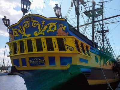 AttractionÉtoile du Roy500 m south, in Saint-Malo6
 AquariumGrand aquarium de Saint-Malo4.5 km southeast, in Saint-Malo7AttractionAttractionTombeau de Chateaubriand800 m west, in Saint-Malo8FortFortRemparts de Saint-Malo400 m south, in Saint-Malo
Within 15 km, close and well known first. Numbers match the map.
Questions people have about Fort National
Where is Fort National?
Fort National is in Saint-Malo, in Ille-et-Vilaine (Brittany).
What is Fort National?
Fort in Ille-et-Vilaine, France.
Is Fort National a historic monument?
Yes: Classé historic monument (in part), since 1906, Mérimée record PA00090810.
How well known is Fort National?
Fort National has 8 Wikipedia and sister-site articles in different languages: #878 of the 37,318 French places we list.
When is the best time to visit Fort National?
May to September are the warmest months in Saint-Malo, with afternoon highs of 17–22°C (Météo-France 1991–2020 normals).
What else is there to see near Fort National?
Within 15 km: Cathédrale Saint-Vincent de Saint-Malo (600 m), Château de Saint-Malo (400 m), Tour Solidor (2.3 km) and Fort du Petit Bé (1.1 km).
Sources: OpenStreetMap (© OpenStreetMap contributors, ODbL), Wikidata (CC0: what it is, its articles, how widely it is covered), the Culture ministry’s Mérimée database (Licence Ouverte 2.0), IGN commune boundaries, Météo-France 1991–2020 normals (Licence Ouverte 2.0).
Photos from Wikimedia Commons, each under its own licence (our copy, resized).
Photo credits (3)
- Fort National: Pline, CC BY-SA 3.0, Wikimedia Commons
- Étoile du Roy: Proullon, CC BY-SA 4.0, Wikimedia Commons
- Grand aquarium de Saint-Malo: MaxTab, CC BY 3.0, Wikimedia Commons
Contains public sector information under the Licence Ouverte / Open Licence 2.0 (Etalab): INSEE, DGFiP, the Interior Ministry’s statistics service (SSMSI), the Ministry of Education (DEPP), the Health Ministry’s statistics service (DREES) and the Housing Ministry (Carte des loyers). Commune boundaries: IGN Admin Express.