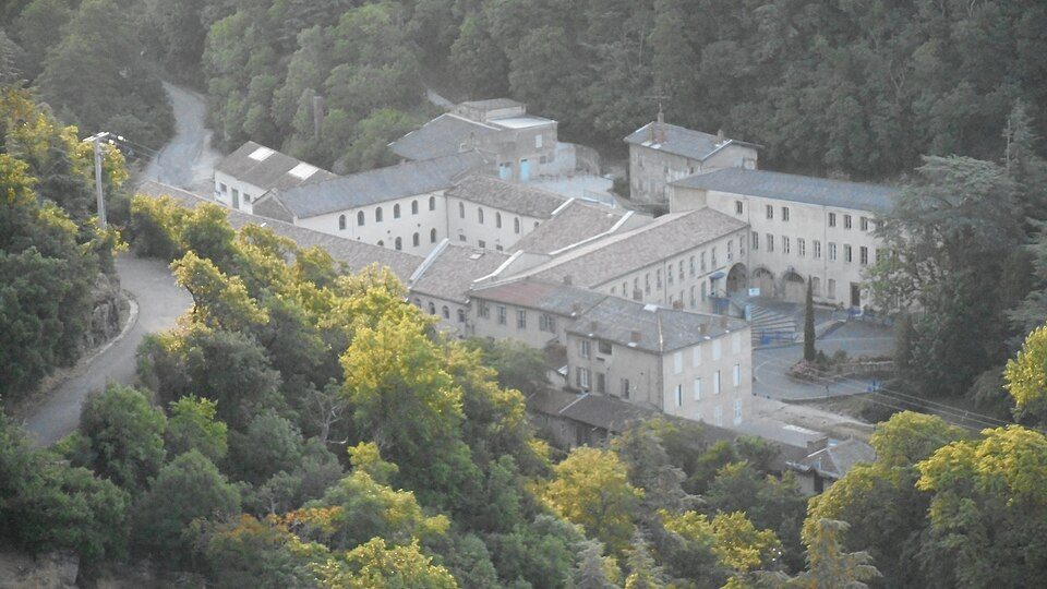
Saint-Clair’s draw is Château de Gourdan
Most of what there is to see is châteaux or heritage sites: 9 of 16. Only one place to visit is in Saint-Clair, but 15 more are within 5 km of its centre. France lists one of the town’s sites as a historic monument. The trip to Centrale nucléaire de Saint-Alban is 16 km.
What Saint-Clair is known for
Behind Château de Gourdan on the list are 2 monasteries, a zoo and a museum.
 MuseumMusée des Papeteries Canson et Montgolfier2.6 km south, in DavézieuxChâteauChâteauDomaine de Marc Seguin2.1 km southwest, in AnnonayMonastery or conventMonastery or conventCouvent Sainte-Marie d'Annonay4.2 km south, in AnnonayMonastery or conventMonastery or conventMonastère de Colombier-le-Cardinal4.4 km east, in Colombier-le-Cardinal
Best known first: by how many Wikipedia and sister-site articles cover each place (Wikidata’s count). It isn’t a ranking of how good they are.
Mapped around Saint-Clair
Close by, the 15 mostly lie to the south.
The first 20 on the list, numbered as below. The shape is the commune of Saint-Clair; the orange dot is its centre. © OpenStreetMap contributors · commune boundary: IGN
What sort of places
Ahead are châteaux or heritage sites (9); next, museums or galleries (4).
Dark: in Saint-Clair. Light: in the communes within 5 km of its centre.
The full list
First the one in town, then the 15 within 5 km of its centre.
Couvent Sainte-Marie d'Annonay
Convent located in Ardèche, in France.
Monastère de Colombier-le-Cardinal
Monastery located in Ardèche, in France.
 8
The one place in Saint-Clair, then those within 5 km of its centre.
The history of Saint-Clair → · Parks and trails in Saint-Clair →
A drive away
Out of town, Centrale nucléaire de Saint-Alban (16 km) leads 12 names to know.
 AttractionCentrale nucléaire de Saint-Alban16 km north, in Saint-Maurice-l'Exil
 AttractionCathédrale Saint-Maurice de Vienne31 km northeast, in VienneAttractionAttractionTemple d'Auguste et de Livie31 km northeast, in Vienne
 CathedralCathédrale Saint-Charles-Borromée de Saint-Étienne30 km northwest, in Saint-ÉtienneAttractionAttractionPalais idéal27 km east, in Hauterives
 MuseumChâteau de Tournon26 km southeast, in Tournon-sur-Rhône
 MuseumÉglise Saint-Pierre de Vienne31 km northeast, in Vienne
 ChurchÉglise Saint-Pierre de Firminy33 km west, in FirminyChâteauChâteauChâteau d'Albon15 km east, in AlbonChâteauChâteauChâteau de Virieu16 km north, in Pélussin
 MuseumMusée d'Art moderne et contemporain de Saint-Étienne Métropole32 km northwest, in Saint-Priest-en-Jarez
 ChâteauChâteau de Crussol40 km south, in Saint-Péray
Places within 40 km of Saint-Clair with an article in both French and English Wikipedia, nearest first.
Good to know in Saint-Clair
What is there to see in Saint-Clair?
The one place mapped in Saint-Clair is Château de Gourdan. We list 1 place in town. Another 15 are within 5 km of the centre.
Are there museums in or near Saint-Clair?
4 museums and galleries in town or within 5 km, including Musée des Papeteries Canson et Montgolfier, Espace du Parchemin et du Cuir, Musée Vivarois César Filhol and Musée du Papier, des Arts et de la Technologie.
Which places in Saint-Clair are listed historic monuments?
One place on this page in Saint-Clair is a listed or registered historic monument (Mérimée): Château de Gourdan.
What well-known places are within a day out of Saint-Clair?
The nearest with articles in both French and English Wikipedia: Centrale nucléaire de Saint-Alban (16 km), Cathédrale Saint-Maurice de Vienne (31 km), Temple d'Auguste et de Livie (31 km), Cathédrale Saint-Charles-Borromée de Saint-Étienne (30 km).
How is this list made?
From OpenStreetMap and Wikidata: named museums, galleries, châteaux, abbeys, gardens, zoos, theme parks and other visitor attractions whose mapped point lies inside the commune of Saint-Clair, then those in the communes within 5 km of its centre, and well-known places within 40 km. Houses, ruins and gardens need a sign they’re open to visitors; places marked private, closed or disused are left out. The historic-monument link is the Culture ministry’s Mérimée record. A place that isn’t mapped isn’t listed, so this isn’t everything there is to see.
Sources: OpenStreetMap (© OpenStreetMap contributors, ODbL), Wikidata (CC0: descriptions, websites, Wikipedia articles), the Culture ministry’s Mérimée database (Licence Ouverte 2.0), IGN commune boundaries. Distances are from the commune’s centre point.
Photos from Wikimedia Commons, each under its own licence (our copy, resized).
Photo credits (10)
- Musée des Papeteries Canson et Montgolfier: Mattho69, CC BY-SA 4.0, Wikimedia Commons
- Château de Déomas: Charcutaille, CC BY-SA 3.0, Wikimedia Commons
- Centrale nucléaire de Saint-Alban: Pilat.Oueb, CC BY-SA 4.0, Wikimedia Commons
- Cathédrale Saint-Maurice de Vienne: SashiRolls, CC BY-SA 4.0, Wikimedia Commons
- Cathédrale Saint-Charles-Borromée de Saint-Étienne: Velvet, CC BY-SA 3.0, Wikimedia Commons
- Château de Tournon: Charcutaille, CC BY-SA 3.0, Wikimedia Commons
- Église Saint-Pierre de Vienne: SashiRolls, CC BY-SA 4.0, Wikimedia Commons
- Église Saint-Pierre de Firminy: Peter Christian Riemann, CC BY-SA 4.0, Wikimedia Commons
- Musée d'Art moderne et contemporain de Saint-Étienne Métropole: AlSepPhoenix, CC BY-SA 4.0, Wikimedia Commons
- Château de Crussol: Jacques FORÊT : Sequajectrof, CC BY-SA 2.5, Wikimedia Commons
Contains public sector information under the Licence Ouverte / Open Licence 2.0 (Etalab): INSEE, DGFiP, the Interior Ministry’s statistics service (SSMSI), the Ministry of Education (DEPP), the Health Ministry’s statistics service (DREES) and the Housing Ministry (Carte des loyers). Commune boundaries: IGN Admin Express.