More historic than 18% of U.S. towns · #242 of 638 in Florida. What drives it
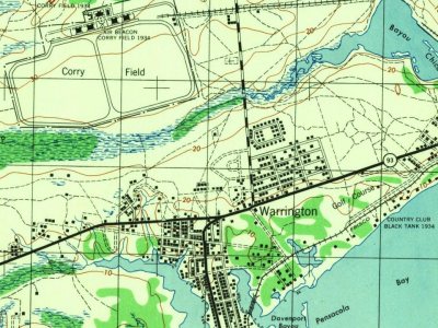
Most of Warrington was built recently: 2% of its homes predate 1940 and the median home dates from 1966. Below: maps from 1944 on and the census since 1950.
Founding year: the first Warrington post office (Blevins & Helbock, CC0).The full story ↓
History grade
What drives Warrington’s History grade
On its age, its old homes and the National Register, Warrington is more historic than 18% of U.S. towns, #242 of 638 in Florida. Its age holds the grade up; its share of homes from before 1940 pulls it down.
C−
HistoryA character grade: shown, never part of Warrington’s overall grade.
Few Florida towns list much on the Register (a typical Florida town has 0.0 per 10,000 residents, the U.S. 2.4), so Warrington’s 0.0 sits below most of its state (33% of Florida towns have fewer) while its 0 listings outnumber those of 23% of U.S. towns.
How sure. Graded on any two of the three inputs instead, the letter would range from D to C. The pre-1940 share (±1.2 points) is firm at this size. The founding year is the first post office, not a stated founding date.
Founding year: the first post office (other dates in Quick answers). Homes: Census ACS 2020–24. National Register: National Park Service, May 2026 list; each listing counted once (boundary changes and added documentation belong to their listing), and a historic district counts its contributing buildings. How TownRatings grades history →
What stands out about Warrington’s past
Read from the archive, the National Register and the record. The page puts what stands out first.
Warrington is named for Lewis Warrington, who served as Secretary of the Navy, and who helped choose the area that became Naval Air Station Pensacola. He served as the first commandant of the newly created Navy Yard, 1826–1827.
Warrington was created shortly after the Pensacola Navy Yard's 1826 foundation. Commodore Melancthon Taylor Woolsey, the second commandant of the Navy Yard (1827–1831), "created two villages, Warrington, and Woolsey outside the navy yard for homebuilding." Warrington was between the yard and Fort Barrancas. The town was relocated north of Bayou Grande in the 1930s to make additional space available for the expanding Naval Air Station.
Passages that mention Warrington, cut from the printed page as they were published.
Annals of the lords of Warrington for the first five centuries after the conquest.1872 · page 173Read the page →
Read the text
and of people that dwelt in forests one fifteenth. In pursuance of this act inquisitions upon the oath of the parishioners were taken in every parish, when the return made for the parish of Warrington was as follows : “ Werington unde ecclesia tax’ ad xx. marc. Verus valor nonae garbar’ veiled et agnorum parochise ejusdem xx. marc., unde villat’.
Text read by machine from the scan; it may contain errors.
Annals of the lords of Warrington for the first five centuries after the conquest.1872 · page 222Read the page →
Read the text
That useful work, the building anew and in a more substantial manner the bridge over the Mersey at Warrington was principally due to him ; and to him also we are inclined to ascribe the foundation of the Boteler chantry in Warrington church, which strengthened the hands of the parish clergy in their ministrations. Among sir John’s multifarious employments was his commission to sit as a commissioner to examine witnesses on the part of Grosvenor in the heraldic dispute,
Text read by machine from the scan; it may contain errors.
Scans and text from the Internet Archive. Books published in 1930 or earlier, which are in the public domain.
Timeline
Warrington, 1850 to 1944
Woven from the archive, old maps, post office records, the National Register and the people born here.
The Warrington post office opened in 1850, the earliest record of the town by name (U.S. post office records).
How does Warrington rank for history?
Warrington is more historic than 18% of U.S. towns, #242 of 638 in Florida. The History grade combines the town’s founding era, the share of homes built before 1940 and its National Register listings. It’s a character grade, so it isn’t part of the overall grade. How it works.
How old are the homes in Warrington?
2% of Warrington’s homes were built before 1940 (Census estimate, ±1.2 points), against a typical 0.6% for a Florida town; the median home was built in 1966.
Founding dates: Wikidata, Wikipedia, the U.S. post office records of Blevins & Helbock (CC0) and the Census. Homes by year built: Census ACS 2020–24. National Register of Historic Places: National Park Service (list of May 22, 2026). Old photos, postcards and papers: Wikimedia Commons, the Library of Congress and other public archives, credited on each item’s page. Maps: U.S. Geological Survey historical topographic maps (via Esri) and Sanborn fire-insurance maps (Library of Congress). History text and census tables: Wikipedia (CC BY-SA 4.0). Places that used to be: USGS Geographic Names Information System (2021).
From Wikimedia Commons (1), Wikidata (1), Wikipedia, U.S. Geological Survey historical maps, U.S. Census counts (via Wikipedia), the US Post Offices dataset (Blevins & Helbock), the USGS Geographic Names Information System and old county and town histories (Internet Archive). Archive images are copied here with their credits and licenses, shown on each photo’s page. Refreshed monthly.


 2004


