Before the 17th century, the Pequot people lived in this portion of southeastern Connecticut. They were in control of a considerable amount of territory, extending toward the Pawcatuck River to the east and the Connecticut River to the west.
Fire insurance maps drew every building, what it was made of and what it was used for, so insurers could price the risk of fire. Pick a year, then a sheet.
Sanborn Map Company, via the Library of Congress. Editions published in 1930 or earlier, which are in the public domain.
From the old history books
What they wrote about Mystic, 1882–1909
Passages that mention Mystic, cut from the printed page as they were published.
History of New London county, Connecticut, with biographical sketches of many of its pioneers and prominent men1882 · page 680Read the page →
Read the text
voted to buy the bridge and franchises of the company for eight thousand dollars, two thousand dollars in addition having been subscribed by the citizens of the villages of Mystic Bridge and Mystic River. Deacon B. F. Langworthy and Capt, John Holbridge, the representativets of the town of Stonington for that year, were charged with the management of the matter before the Legislature in connection with the rep-
Text read by machine from the scan; it may contain errors.
History of New London county, Connecticut, with biographical sketches of many of its pioneers and prominent men1882 · page 668Read the page →
Read the text
Mystic Methodist Episcopal Church.— As early as 1816 several Methodist clergymen visited Mystic and preached occasionally. But no efforts were made to organize a class preparatory to the promotion of a church until 1824, when a class was organized consisting of seven persons. No minister was stationed at Mystic until 1826, when the Rev. Newell S. Spalding was assigned to that place. The first Quarterly
Text read by machine from the scan; it may contain errors.
The school advantages in Old Mystic are now better than can be found in most towns outside the large cities. Formerly the northeastern section of the town including the village was a part of the Burnet's Corners district. In 1851 that section of Groton was incorporated with the sixth school district of Stonington, having its school house already in the
Text read by machine from the scan; it may contain errors.
The highway from the west end of the bridge around by the machine works to the New London ruad was opened when the bridge was built. The road between Mystic and Noank was opened in 1833. The ri\-er road from West Mystic to Old ;\Iystic was opened in 1853. The road on the east side of the river to Old Mystic is older. The higli-
Text read by machine from the scan; it may contain errors.
Scans and text from the Internet Archive. Books published in 1930 or earlier, which are in the public domain.
Timeline
Mystic, 1805 to 1940
Woven from the archive, old maps, post office records, the National Register and the people born here.
Nothing in the archives for these yearsWeddings on Main Street, storms, parades, school pictures, the old store. If it’s in your family album, it belongs here.
Nothing in the archives for these yearsWeddings on Main Street, storms, parades, school pictures, the old store. If it’s in your family album, it belongs here.
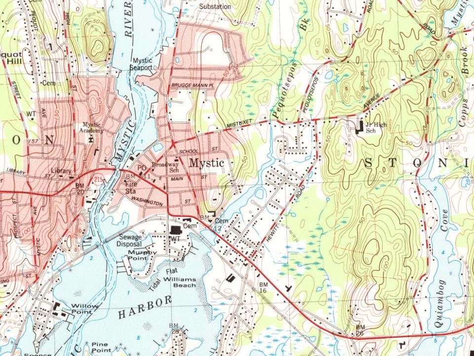
Founding dates: Wikidata, Wikipedia, the U.S. post office records of Blevins & Helbock (CC0) and the Census. Homes by year built: Census ACS 2020–24. National Register of Historic Places: National Park Service (list of May 22, 2026). Old photos, postcards and papers: Wikimedia Commons, the Library of Congress and other public archives, credited on each item’s page. Maps: U.S. Geological Survey historical topographic maps (via Esri) and Sanborn fire-insurance maps (Library of Congress). History text and census tables: Wikipedia (CC BY-SA 4.0). Places that used to be: USGS Geographic Names Information System (2021). How TownRatings grades history →
From Wikimedia Commons (12), Wikipedia, Wikidata and Wikipedia for famous people, U.S. Geological Survey historical maps, U.S. Census counts (via Wikipedia), Sanborn fire insurance maps (Library of Congress) and old county and town histories (Internet Archive). Archive images are copied here with their credits and licenses, shown on each photo’s page. Refreshed monthly.




 c. 1907
 1907–1915
 c. 1940
 2007
 2007
 2007
 2007
 2006
 2004

