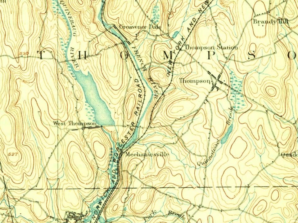
Every edition of the U.S. Geological Survey’s map of Mechanicsville. Tap a year, or press play to watch the town change.
1889Putnam sheet · 1:62,500
U.S. Geological Survey historical topographic maps (public domain), via Esri’s collection of the scans. The red ring marks the center of Mechanicsville.
The story so far
Mechanicsville, in brief
Wikipedia doesn’t have a history of Mechanicsville yet. The photos, dates and memories neighbors add here are how it gets written.
Mechanicsville is an unincorporated community and census-designated place (CDP) in the southern part of the town of Thompson in Windham County, Connecticut, United States. It is bordered to the north by North Grosvenordale and to the south by Putnam. Connecticut Route 12 (Riverside Drive) runs the length of the community, along the east side of the French River. Mechanicsville was first listed as a CDP prior to the 2020 census. As of the 2020 census, Mechanicsville had a population of 540. A portion of the Air Line State Park Trail passes through Mechanicsville, along with the Providence and Worcester Railroad.
Its first post office opened in 1873.
Intro from Wikipedia. Population: U.S. Census Bureau.
From the old history books
What they wrote about Mechanicsville, 1889–1920
Passages that mention Mechanicsville, cut from the printed page as they were published.
A modern history of Windham county, Connecticut1920 · page 290Read the page →
Read the text
To touch first upon practical things it may be said there are three railroads in the town with stations at East Thompson and Thompson on the Boston and Poughkeepsie Division, at Wilsonville, North Grosvenordale, Grosvenordale, West Thompson and Mechanicsville on the Worcester Division while at East Thompson the Southbridge Branch pursues a serpentine course into Massachusetts to return to Connecticut with a station at Quinebaug and then goes on into Massachusetts again to its terminus. At Quinebaugh is found the peculiar condition of the station and postoffice being in Connecticut, while the
Text read by machine from the scan; it may contain errors.
History of Windham County, Connecticut ..1889 · page 548Read the page →
Read the text
early part of 1885 the foundations of a new Catholic church were laid in the northeastern part of the town., a mile or more from Pomfret street. In 1886 this region was made a part of the parish of Mechanicsville, and placed under the pastoral care of Reverend Father Flannagan. The church was so far completed that services were held in it on Easter Sunday in 1887, and it was dedicated a few months later.
Text read by machine from the scan; it may contain errors.
A Modern History of Windham County, Connecticut1920 · page 1108Read the page →
Read the text
It was his plan to follow his trade in some large Connecticut factory and he settled in Thompson, where he was soon given employment as watchman in the Grosvenor Dale mills. He acted in that capacity for a number of years and then went to the village of Mechanicsville, where he obtained a position in a woolen mill. Several years later he invested his savings in a farm of thirty acres in Thompson and devoted two years to general agricultural pursuits. He afterward spent four years in Mechanicsville and on the expiration of that period established a grocery store in Putnam, becoming a partner in the firm of P. O'Leary & Company. This partnership relation was maintained
Text read by machine from the scan; it may contain errors.
History of Windham County, Connecticut ..1889 · page 696Read the page →
Read the text
Mechanicsville dates back to 1827, when a privilege upon the French river, just above its junction with the Quinebaug, was secured by a number of enterprising men, viz., Erastus Buck, Augusus Howe, Thomas and James Dike, Jude Sabin, John Chollar, Jacob Leavens and James Cunningham, who associated together as "The Mechanics' Company " for the manufacture of woolen goods, and put up a three-story wooden mill, a saw mill and an eight-tenement block for operatives. All members of
Text read by machine from the scan; it may contain errors.
Scans and text from the Internet Archive. Books published in 1930 or earlier, which are in the public domain.
By decade
Mechanicsville, decade by decade
One decade in the archive so far: the 1900s. Scroll each row; tap a photo for its story.
Nothing in the archives for these yearsWeddings on Main Street, storms, parades, school pictures, the old store. If it’s in your family album, it belongs here.
Founding dates: Wikidata, Wikipedia, the U.S. post office records of Blevins & Helbock (CC0) and the Census. Homes by year built: Census ACS 2020–24. National Register of Historic Places: National Park Service (list of May 22, 2026). Old photos, postcards and papers: Wikimedia Commons, the Library of Congress and other public archives, credited on each item’s page. Maps: U.S. Geological Survey historical topographic maps (via Esri) and Sanborn fire-insurance maps (Library of Congress). History text and census tables: Wikipedia (CC BY-SA 4.0). Places that used to be: USGS Geographic Names Information System (2021). How TownRatings grades history →
From Wikimedia Commons (6), U.S. Geological Survey historical maps and old county and town histories (Internet Archive). Archive images are copied here with their credits and licenses, shown on each photo’s page. Refreshed monthly.




 1907–1915
 2020
 2019
 2013
 2013
 2013


