Brooklyn dates to 1786, and 16% of its homes were built before 1940
More historic than 85% of U.S. towns · #71 of 155 in Connecticut. What drives it
6 places in town are on the National Register, among them three historic districts with 137 buildings between them. Below: 15 old photos and papers, maps from 1889 on, and the census since 1820.
Founding year: Wikipedia. First post office: 1802.The full story ↓
History grade
What drives Brooklyn’s History grade
On its age, its old homes and the National Register, Brooklyn is more historic than 85% of U.S. towns, #71 of 155 in Connecticut. All 3 inputs are above most U.S. towns; its National Register listings ranks highest and its share of homes from before 1940 lowest.
A
HistoryA character grade: shown, never part of Brooklyn’s overall grade.
Connecticut towns list more on the Register than most of the country (a typical Connecticut town has 73.3 per 10,000 residents, the U.S. 2.4), so Brooklyn’s 166 sits above most of its state (69% of Connecticut towns have fewer) while its 141 historic buildings outnumber those of 91% of U.S. towns.
How sure. Graded on any two of the three inputs instead, the letter would still be A−. The pre-1940 share is a Census survey estimate (±4.7 points). Two sources give 1786.
Founding year: Wikipedia (other dates in Quick answers). Homes: Census ACS 2020–24. National Register: National Park Service, May 2026 list; each listing counted once (boundary changes and added documentation belong to their listing), and a historic district counts its contributing buildings. How TownRatings grades history →
What stands out about Brooklyn’s past
Read from the archive, the National Register and the record. The page puts what stands out first.
Brooklyn was settled in the late 17th century and incorporated as its own town in 1786. It is named for the Quinebaug River, or Brook Line, which forms its eastern boundary. Brooklyn was originally land of the Wabaquasset. It was incorporated as a town separate from Canterbury and Pomfret in May 1786. It is home to the Brooklyn Fair, America's oldest continuously operating agricultural fair, as well as the Brooklyn Correctional Institution, a state-run medium security prison.
Brooklyn held the 1833 trial of Prudence Crandall, a schoolteacher charged with the crime of educating black female students in nearby Canterbury.
Passages that mention Brooklyn, cut from the printed page as they were published.
A history of the equestrian statue of Israel Putnam, at Brooklyn, Conn1888 · page 14Read the page →
Read the text
To all people to whom these presents shall come, greeting : Know ye that I, Thomas S. Marlor of the town of Brooklyn, County of Windham, and State of Connecticut, for the consideration of One Dollar received to my full satisfaction of the State of Connecticut, do give, grant, bargain, sell, and confirm unto the said State of Connecticut, certain land situated in said Brooklyn, and described as follows, to wit : A certain driveway situated on the south side of property deeded by this grantor to the State by
Text read by machine from the scan; it may contain errors.
A history of the equestrian statue of Israel Putnam, at Brooklyn, Conn1888 · page 13Read the page →
Read the text
The same to be built in the town of Brooklyn, Connecticut, in such place as said agents shall designate, and said pedestal and statue are to be placed thereon by said Gerhardt.
Text read by machine from the scan; it may contain errors.
Scans and text from the Internet Archive. Books published in 1930 or earlier, which are in the public domain.
Timeline
Brooklyn, 1757 to 2020
Woven from the archive, old maps, post office records, the National Register and the people born here.
Nothing in the archives for these yearsWeddings on Main Street, storms, parades, school pictures, the old store. If it’s in your family album, it belongs here.
In 1786, according to Wikipedia’s history of the town. Brooklyn’s post office opened in 1802, and the census of 1820 counted 1,254 people here.
How does Brooklyn rank for history?
Brooklyn is more historic than 85% of U.S. towns, #71 of 155 in Connecticut. The History grade combines the town’s founding era, the share of homes built before 1940 and its National Register listings. It’s a character grade, so it isn’t part of the overall grade. How it works.
What is on the National Register in Brooklyn?
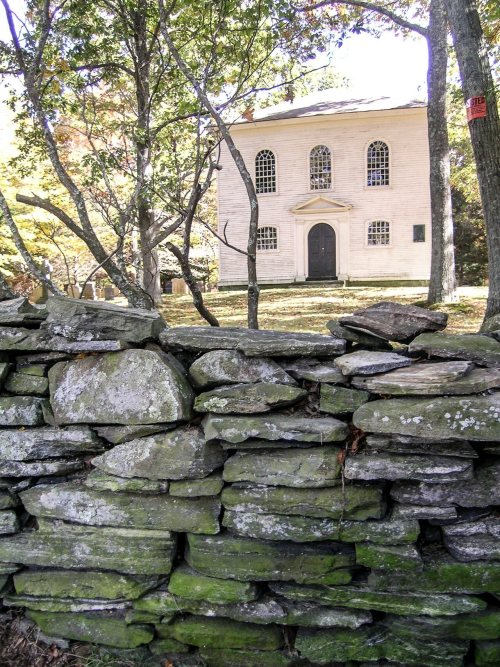
6 listings: 3 buildings, among them the Trinity Church (listed 1970, the first), and 3 historic districts, the Brooklyn Green Historic District, the Quinebaug Mill-Quebec Square Historic District and the Bush Hill Historic District, with 137 contributing buildings. 141 historic buildings in all.
How old are the homes in Brooklyn?
16% of Brooklyn’s homes were built before 1940 (Census estimate, ±4.7 points), against a typical 15% for a Connecticut town; the median home was built in 1978.
Founding dates: Wikidata, Wikipedia, the U.S. post office records of Blevins & Helbock (CC0) and the Census. Homes by year built: Census ACS 2020–24. National Register of Historic Places: National Park Service (list of May 22, 2026). Old photos, postcards and papers: Wikimedia Commons, the Library of Congress and other public archives, credited on each item’s page. Maps: U.S. Geological Survey historical topographic maps (via Esri) and Sanborn fire-insurance maps (Library of Congress). History text and census tables: Wikipedia (CC BY-SA 4.0). Places that used to be: USGS Geographic Names Information System (2021).
From Wikimedia Commons (20), the Library of Congress (11), Wikidata (2), the National Register of Historic Places (6), Wikipedia, Wikidata and Wikipedia for famous people, U.S. Geological Survey historical maps, U.S. Census counts (via Wikipedia), the US Post Offices dataset (Blevins & Helbock), the USGS Geographic Names Information System and old county and town histories (Internet Archive). Archive images are copied here with their credits and licenses, shown on each photo’s page. Refreshed monthly.







 1940
 1940
 1940
 1995
 Date?
 Date?
 Date?
 Date?
 Date?
 Date?
 Date?
 Date?
 Date?
 2025
 2024
 2024
 2024
 2024
 2024
 2024
 2022
 2020
 2019
 2019
 2019
 2019
 2018
 2015
 2010


