
 Top
National Historic Site · 1889–1892Government House4607 Dewdney AvenuePhoto: Scotwood72 · Public domain · Commons file
 Photo: Yakky97 · CC BY-SA 4.0
1historic place on the registers
History of McNab · Canada’s heritage registers
One place in McNab, at the top of the registers
Few towns have as much for their size as McNab: 4 for every 10,000 residents, more than 93% of Canadian towns. The one entry is Government House (1889), a national historic site.
Historic places
1
4 per 10,000 residents
Highest designations
1
National Historic Sites and Classified Federal Heritage Buildings
Oldest building
1889
the first construction date on its record
Homes built before 1961
19%
typical town: 18%
In pictures
McNab’s landmarks
One place in McNab is on the registers, and this is it: Government House.
Photos from Wikimedia Commons, each credited to its photographer with its licence; names open the place’s page. Tap a photo to step through them full screen.
Through time
McNab, long ago
One picture from before 1950: the oldest view of one of its historic places. It opens full screen with a tap.
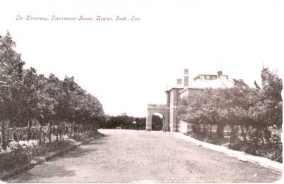 c. 1915
Public domain or CC0, made before 1950, from Wikimedia Commons; old views of places can be drawings, prints or maps of their time. Each credit opens the image’s page.
The map
Where McNab’s history is
Every place on the registers inside the town, by its designation.
Highest designations
Dots open their places’ pages; hover first to read the name.
The 1, by tier
1 Highest designations
Most entries are federal, from Parks Canada’s Directory of Federal Heritage Designations; local listings outside Québec are known only through Wikidata items with an article.
Points from Wikidata (Parks Canada’s files carry none) and from Québec’s register, as mapped there.
Highest designations
One place in McNab with the highest designation
National Historic Sites and Classified Federal Heritage Buildings, Canada’s highest federal recognition. Each one opens its own page.
Around the town
Within 5 km of McNab: 6 places on the registers
They belong to 3 towns, chiefly Downtown, Dewdney Place and Hillsdale. At 2.8 km, Knox-Metropolitan United Church in Downtown is the closest. Among them are 4 provincial or municipal listings, a heritage railway station and a National Historic Site.
The 6 nearest, within 5 km
| Knox-Metropolitan United ChurchMunicipal heritage property · 1907 · 2.8 km away, in Downtown |
| Albert Memorial BridgeMunicipal heritage property · 1930 · 3 km away, in Dewdney Place |
| Hotel SaskatchewanMunicipal heritage property · 3.1 km away, in Downtown |
| Prince Edward BuildingMunicipal heritage property · 1907 · 3.1 km away, in Downtown |
| Former Canadian Pacific Railway Station, Regina, SaskatchewanHeritage Railway Station · 1911–1914 · 3.2 km away, in Downtown |
| Saskatchewan Legislative Building and GroundsNational Historic Site · 1908–1913 · 3.4 km away, in Hillsdale |
Homes by age
McNab is still building: 33% of homes date from 2016 to 2021, against 4.1%
Few of McNab’s homes date from 1981 to 2000: 11%, the norm 23%. Homes built from 2001 to 2015 make up just 4.9% of McNab’s, against 15% in the typical town. McNab’s largest group of homes, 33%, went up from 2016 to 2021.
19%
Before 1961
29%
1961–80
11%
1981–2000
4.9%
2001–15
33%
2016–21
McNabTypical town
2021 Census, private dwellings by period of construction (Statistics Canada); the typical town is the middle Canadian town of 2,500 or more.
Towns its size
McNab has the 1st most of 16 towns its size
Towns of 2,500 to 2,500 residents, by places on the registers.
McNab1
The typical town its size has 0. 10 of them have nothing on the registers.
Neighbours
McNab and its neighbours
| Town | People | Places | Highest | Oldest |
|---|---|---|---|---|
| McNab | 2,510 | 1 | 1 | 1889 |
| Rosemont/Mount Royal | 10,497 | 0 | 0 | — |
| North Central | 9,124 | 0 | 0 | — |
| Cathedral Village | 7,311 | 0 | 0 | — |
| Normanview Residents Group | 3,916 | 0 | 0 | — |
| Normanview West | 2,866 | 0 | 0 | — |
| Downtown | 4,282 | 4 | 0 | 1907 |
In brief
McNab in brief
Before 1961: 19% of McNab’s homes, against 18% in the typical town. The lists come to 1 historic place, one with the highest designation, including Government House. No town its size has more historic places: it leads the 16 nearest in population. Beyond that, its one place was designated in 1968.
How to read these numbers
What this data can and can’t tell you
- The tiers. National Historic Sites and the most protected buildings form the top tier; recognized federal buildings, stations and lighthouses the second; provincial and municipal listings the third.
- Protection. A National Historic Site designation recognises significance; it doesn’t by itself protect a building the federal government doesn’t own. Legal protection comes from provincial and municipal designations, whose own registers aren’t open data outside Québec.
- The grade. History isn’t one of Canada’s graded pillars, so this page describes and compares without a letter.
- People and events. Persons of national historic significance come with no location; a town gets one only by birthplace (name and both life years agreeing) or by one of its own places that bears the name and whose record tells the story. Events, which can’t be tied, are left out.
- The federal register. Federal places come from Parks Canada’s directory, which counts National Historic Sites, federal heritage buildings, stations and lighthouses; their statements are the register’s own.
- Provincial and municipal lists. Only Wikidata gives open access to listings on provincial and municipal registers outside Québec; without an article such a place is counted but not paged.
- Map points. Where a federal place sits on the map is Wikidata’s placing; the directory itself has no coordinates.
Questions about McNab’s history
Which places in McNab have the highest designation?
It is Government House.
What is the oldest building in McNab?
Government House (National Historic Site): the first construction date on its record is 1889.
How old are the homes in McNab?
The 2021 Census dates 19% of its homes before 1961 (18% in the typical town).
Contains information licensed under the Open Government Licence – Canada (Parks Canada).
Sources: Parks Canada, Directory of Federal Heritage Designations · Canadian Register of Historic Places (federal extract) · Wikidata (CC0) for map points, other names and articles · Statistics Canada, 2021 Census (homes by period of construction). Under the Statistics Canada Open Licence.
Adapted from Statistics Canada (Census of Population 2021, population estimates 2025, 2021 census boundaries) under the Statistics Canada Open Licence; this does not constitute an endorsement by Statistics Canada. Neighbourhood names in some cities © OpenStreetMap contributors (ODbL).