
PurplevilleVaughan
19,918 people live in this neighbourhood in Vaughan. Of Vaughan’s 24 neighbourhoods, this is one.
Is Purpleville a good place to live?
A well-rated place to live, with prices to match. Schools do well (A). Health is a strength (A). The trade-off is cost of living (C). Put together, the subjects come to an A− overall, ranking #110 of 858 in Ontario. That leaves it better than 80% of Canadian towns.
Rents here are the metro area's average, shared by every town and neighbourhood in it. Safety less sure: this is the whole city's figure, because the city doesn't publish open neighbourhood crime rates. Health is graded on the health region's survey figures and life expectancy, with the distance to hospital giving the town its own spread.
What makes Purpleville stand out
The 3 things Purpleville does most differently from other towns.
How Purpleville grades
Each subject compares Purpleville with Canadian towns of 2,500 or more, ordered by how far it is from the middle. Towns in other countries are graded separately.
How TownRatings grades Canadian towns →
McMichael Canadian Art Collection and 52 more in and around Purpleville
A first look at Purpleville’s museums, historic sites and days out, and a few just outside town.
 MuseumMcMichael Canadian Art Collectionin town
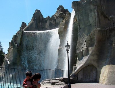 Big drawTheme parkCanada's Wonderland800 m outside town, to the southeast · 3.2M visitors a year (2025)
 AttractionLeviathan700 m outside town, to the east
 AttractionYukon Striker900 m outside town, to the southeast
 AttractionBehemoth1.1 km outside town, to the southeast
 AttractionMighty Canadian Minebuster1 km outside town, to the southeast
Photos: each place’s Wikidata image, from Wikimedia Commons under the licence below (our copy, resized).
Photo credits (6)
- McMichael Canadian Art Collection: Stephanie Spencer, CC BY-SA 2.5, Wikimedia Commons
- Canada's Wonderland: Mathew Ingram, CC BY 2.0, Wikimedia Commons
- Leviathan: Chris!!!!!, CC BY 2.0, Wikimedia Commons
- Yukon Striker: Jason Zhang, CC BY-SA 3.0, Wikimedia Commons
- Behemoth: Mindme, CC BY-SA 3.0, Wikimedia Commons
- Mighty Canadian Minebuster: Mike chernucha, CC BY-SA 2.0, Wikimedia Commons
The data
Data highlights are ordered by what stands out in Purpleville.
Four parallel systems run Purpleville’s schools through 6 boards: English and French, public and Catholic
2 of the 47 teach in French, against 10% of schools in Ontario. Results lean high: 27 of 47 in the top two fifths in Ontario. Also worth knowing: the largest is Tommy Douglas Secondary School, with 1,645 students.
| School | Level | Students | System |
|---|---|---|---|
| Pope Francis Catholic Elementary School CatholicLargest elementary schoolElementary · Grades JK–8 | Elementary · Grades JK–8 | 900 | English Catholic |
| Tommy Douglas Secondary School Second fifth in OntarioLargest secondary schoolSecondary · Grades 9–12 | Secondary · Grades 9–12 | 1,645 | English public |
| École élémentaire La Fontaine FrenchTeaches in FrenchElementary · Grades JK–6 | Elementary · Grades JK–6 | 130 | French public |
| Maple High School Top fifth in OntarioResults in the top fifth in OntarioSecondary · Grades 9–12 | Secondary · Grades 9–12 | 1,590 | English public |
Schools by system · Schools within 3 km
| Schools within 3 km | Purpleville | Ontario | Canada |
|---|---|---|---|
| School boards | 6 | 4 | 3 |
Provincial school lists and results, 2024-25
Hazard risk in Purpleville is lower than in 90% of Canadian towns
Shared with the rest of the city of Vaughan: earthquake risk
Shaking is about as much of a worry in Purpleville as in most places, at $0.028 a year per $1,000 of building value ($0.030 typical). Flood mapping exists: a study by Toronto Regional Conservation Authority.
Radon tests above the guideline · share of tested homes, 200 Bq/m³
| Hazards | Purpleville | Ontario | Canada |
|---|---|---|---|
| Radon tests above the guideline | 0% | 4% | 6.6% |
| Earthquake loss per $1,000 of buildings a year | $0.028 | $0.043 | $0.030 |
NRCan seismic risk model and burned areas, Health Canada radon survey, the Flood Hazard Map Inventory
Purpleville’s region outlives the typical Canadian town by 4.8 years: life expectancy 86.3
Self-rated health is ordinary for Ontario: just over half of the region’s adults say very good or excellent, the province 51%. On average 16% of adults live with arthritis, diabetes or high blood pressure, lower than both Ontario’s towns (17%) and Canadian towns (17%). Measured from where Purpleville’s residents live, a hospital is 4.2 km away, near the 3.7 km most towns see. Behind health survey and life expectancy sits data gathered across the York Regional Health Unit, with Purpleville one part of it.
Very good or excellent health · adults, age-standardised
| Health | Purpleville | Ontario | Canada |
|---|---|---|---|
| Life expectancy at birth | 86.3 | 82.8 | 81.5 |
| Chronic conditions (average share) | 16% | 17% | 17% |
| Smokers | 10% | 10% | 12% |
Statistics Canada, Canadian Community Health Survey 2023/2024 and life expectancy 2022/2024; Open Database of Healthcare Facilities
More households own their home in Purpleville than in Ontario’s towns or across Canadian towns: 91%
30% of households spent 30% or more of their income on shelter, above Ontario’s towns (22%) and Canadian towns (18%) alike. A year’s rent came to 17% of the median household income, lower than both Ontario’s towns (22%) and Canadian towns (20%). Purpleville shares its rent as a share of income and monthly rent for a two-bedroom numbers with the rest of the Toronto metro area.
What homes were worth · The median owner’s estimate at the 2021 census
| Census 2021 | Purpleville | Ontario | Canada |
|---|---|---|---|
| Households spending 30%+ on shelter | 30% | 22% | 18% |
| Households owning their home | 91% | 76% | 74% |
| Rent as a share of income | 17% | 22% | 20% |
Statistics Canada, Census 2021; CMHC Rental Market Survey via Statistics Canada · These are 2021 census values, as owners judged them, set against household income in 2020.
Purpleville gets a B+ for safety
Area-wide: Crime Severity Index, Violent Crime Severity Index, violent crime and property crime per 1,000, counted over the York Region service area
The violent index for its police area came to 67, below Ontario’s towns (76) and Canadian towns (86) alike. Its police area records 21.4 property incidents per 1,000 residents a year. For every 1,000 residents of its police area, 9.7 violent incidents are reported each year.
Year by year · Crime Severity Index for each year
| 2023–2025 | Purpleville | Ontario | Canada |
|---|---|---|---|
| Property crime per 1,000 | 21.4 | 30.5 | 31.2 |
| Violent Crime Severity Index | 67 | 76 | 86 |
| Crime Severity Index | 53 | 56 | 67 |
Statistics Canada, Uniform Crime Reporting Survey, 2023–2025 average
A national park 25 km from Purpleville: Rouge National Urban Park
Protected areas cover 6.2% of the land within 10 km; for the typical Canadian town it is 2.3%. The largest named area nearby is Brampton Natural Heritage System, 1,126 ha, 4.5 km away. Within 10 km, the count of public protected areas is 30, higher than both Ontario’s towns (4) and Canadian towns (4). The closest provincial park is Forks of the Credit Provincial Park, 24 km from the edge of town.
Protected land · of the land within 10 km
| Outdoors | Purpleville | Ontario | Canada |
|---|---|---|---|
| Public protected areas within 10 km | 30 | 4 | 4 |
| Protected land within 10 km | 6.2% | 2.3% | 2.3% |
Canadian Protected and Conserved Areas Database (CPCAD), OpenStreetMap routes and beaches
Trips to work from Purpleville take longer than from Ontario’s towns or Canadian towns: 32 min on average
93% of commuters drove, higher than both Ontario’s towns (88%) and Canadian towns (89%).
How working residents got to work · census 2021
| Census 2021 | Purpleville | Ontario | Canada |
|---|---|---|---|
| Average trip | 32 min | 29 min | 26 min |
| Car or van | 93% | 88% | 89% |
Statistics Canada, Census 2021 (labour and commuting) · These are May 2021 figures, gathered while COVID-19 kept many people home or out of work.
Purpleville has warmer summers than Ontario’s towns or Canadian towns: July afternoons reach 27.3°C
Between the last spring frost, 3 May, and the first in autumn, 13 October, lie 161 days. The coldest nights, in January, bottom out at −10.1°C, lower than Ontario’s towns (−9.1°C) yet higher than Canadian towns (−13.5°C). The most precipitation falls in June: 87 mm in a normal year. Most of the snow comes in January, about 40 cm.
Average high by season · ECCC normals, 1991–2020
| Normals, 1991–2020 | Purpleville | Ontario | Canada |
|---|---|---|---|
| July afternoon high | 27.3°C | 26.7°C | 25.5°C |
| January night low | −10.1°C | −9.1°C | −13.5°C |
| Days with frost a year | 145 | 139 | 159 |
Environment and Climate Change Canada, Canadian Climate Normals 1991–2020 (Toronto Buttonville (Airport))
Visible minorities make up more of Purpleville than of Ontario’s towns or Canadian towns: 48%
0.1% of residents have an Indigenous identity, below both Ontario’s towns (1.6%) and Canadian towns (2.8%).
Ages · Share of residents in each age group, Census 2021
Schooling · Highest qualification, residents 15 and over
Women and men · all residents
Women make up 50.8% of Purpleville
In 2021 there were 10,120 women to 9,805 men; Canada as a whole is 50.9% women.
| Purpleville | Ontario | Canada | |
|---|---|---|---|
| Under 15 | 24% | 15% | 16% |
| 15 to 64 | 67% | 65% | 64% |
| 65+ | 8.3% | 19% | 19% |
| No certificate, diploma or degree | 15% | 15% | 16% |
| Postsecondary qualification | 61% | 56% | 56% |
Statistics Canada, Census 2021; Ontario and Canada: medians of towns of 2,500+
Purpleville in November: highs near 7°C, lows near −1°C
In November, the normal is 77 mm of rain and snow. By December, a normal day reaches 2°C and a night falls to −6°C. Snow is normal by November, about 12 cm over the month. Over the year, July is warmest at 27°C by day and January coldest at −10°C by night.
Normal highs, the months ahead · ECCC normals, 1991–2020
| Season | High | Low | Rain and snow |
|---|---|---|---|
| Winter | 0°C | −9°C | 177 mm |
| Spring | 12°C | 1°C | 211 mm |
| Summer | 26°C | 14°C | 244 mm |
| Autumn | 15°C | 5°C | 230 mm |
ECCC normals, 1991–2020 (Toronto Buttonville (Airport)); the forecast is on the Weather page
One councillor per 35,850 residents: Vaughan is more thinly represented than 98% of Ontario municipalities
Vaughan, which governs Purpleville, elected Steven Del Duca mayor in October 2022.
| Turnout | Purpleville | Ontario | Canada |
|---|---|---|---|
| Municipal election, 2022 | 27% | 31% | 31% |
Wikidata, MAMH, MMAH, Statistics Canada
More visits per person served than 87% of Ontario’s town libraries: Vaughan Public Libraries counts 5.7
Purpleville is served by Vaughan Public Libraries, the library of all of Vaughan, so the figures here are the city’s, for 344,930 people.
Provincial library statistics, OpenStreetMap, the CRA and Statistics Canada
Everything we know about Purpleville
Famous people from around Purpleville
No notable person born in Purpleville is on our list; these were born in the towns around it.


Photo credits
Max Aitken, 1st Baron Beaverbrook: Unknown author, Public domain · Phillip Di Giuseppe: TheAHL, CC BY 2.0
Purpleville’s neighbours
The nearest places of 1,000 or more. Statistics Canada
| Town | People | km | Overall | Cost | Safety | Health |
|---|---|---|---|---|---|---|
| Purpleville | 19,918 | — | A− | C | B+ | A |
| Peace Village | 14,598 | 1.8 | A− | D | B+ | A |
| Vellore | 39,490 | 2.4 | A− | C− | B+ | A |
| Teston | 7,437 | 3.5 | A− | C | B+ | A |
| Maple | 20,122 | 3.6 | A− | D | B+ | A |
| Hope | 6,997 | 5.6 | A− | C− | B+ | A |
| Carrville Corners | 13,004 | 5.6 | A− | C | B+ | A |
People: Statistics Canada, Census 2021. Distances: centre to centre.
Questions about Purpleville
How old are the people of Purpleville?
35.8 is the median age, 45.2 the median among Canadian towns; 8% of residents are 65 or over and 24% under 15.
About Purpleville
Neighbourhood in Vaughan
Where Purpleville begins and ends inside Vaughan is TownRatings’s line, traced along census dissemination areas and named after the city’s map or OpenStreetMap.
Statistics Canada: population estimates 2025 (17-10-0155), Census of Population 2021, 2021 census boundaries.
- Population
- 19,918 (people, 2021 estimate)
- Province or territory
- Ontario
- City
- Vaughan
- Census subdivision
- 3519028
Sources: Statistics Canada, Census of Population 2021 · population estimates 2025 (17-10-0155) and 2021 census boundaries · Uniform Crime Reporting Survey 2023–25 (35-10-0026, 35-10-0183 to 35-10-0190) · CMHC rents as published by Statistics Canada (34-10-0133) · grades by TownRatings. Under the Statistics Canada Open Licence.
Adapted from Statistics Canada (Census of Population 2021, population estimates 2025, 2021 census boundaries) under the Statistics Canada Open Licence; this does not constitute an endorsement by Statistics Canada. Neighbourhood names in some cities © OpenStreetMap contributors (ODbL).