
See Evergreen Brick Works and one more in Leaside-Bennington
84 of the 105 places to visit in and around Leaside-Bennington are museums or galleries. We list 2 places to visit inside Leaside-Bennington’s neighbourhood outline and 103 within 5 km of its edge. Royal Ontario Museum counted 281.4M visitors in 2025. For a longer trip, Canada's Wonderland lies 21 km away.
Leading places in Leaside-Bennington
 Big drawAttractionCN Tower4.5 km outside town, to the south · 1.5M visitors a year
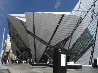 Big drawMuseumRoyal Ontario Museum2.6 km outside town, to the south · 281.4M visitors a year (2025)
 Big drawArt galleryArt Gallery of Ontario3.6 km outside town, to the south · 873K visitors a year (2016)
 Historic houseCasa Loma3 km outside town, to the southwest
Each has a page of its own: what it is, who runs it, the weather month by month and what else is near it.
Mapped around Leaside-Bennington
The dashed line is Leaside-Bennington’s neighbourhood outline; orange marks its middle (where most people live). Numbers match the list below. © OpenStreetMap contributors · Statistics Canada 2021 outline
Kind by kind
Green: inside Leaside-Bennington. Grey: within 5 km of its edge.
All of it
Royal Ontario Museum
Museum of world culture and natural history in Toronto, Ontario, Canada.
 7
The Aga Khan Museum
Museum dedicated to Islamic history, artifacts and art pieces in Toronto, Canada.
 8
 9
 10
Queen's Park
Urban park in Downtown Toronto, Ontario, Canada - located to the north of the Ontario Legislative Building.
 11
 13
 14
 16
 17
 18
 20


The Image Centre
Photography, art museum and education centre in Ontario, Canada.


St. Volodymyr's Ukrainian Orthodox Cathedral
Ukrainian Orthodox cathedral in Toronto, Ontario, Canada.


Royal Canadian Military Institute
Private members' club in Toronto, Ontario.

Art Museum at the University of Toronto
Art museum at the University of Toronto St. George.

Parliament Interpretive Centre
Archeological site in Toronto, Canada.


TD Gallery
Art gallery in the Toronto Reference Library in Toronto, Ontario, Canada.
Kajama
The 2 inside Leaside-Bennington come first, best known first; then the places within 5 km, close and well known first. Provincial and city parks are on the Outdoors page instead.
Historic places in Leaside-Bennington → · Parks, footpaths and green space in Leaside-Bennington →
Beyond the town
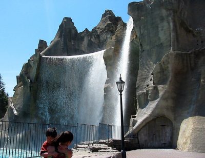 Big drawTheme parkCanada's Wonderland21 km northwest · 3.2M visitors a year (2025)
 GardenHigh Park11 km southwest
 ZooToronto Zoo20 km northeast
 MuseumFort York8.3 km south
 Theme parkOntario Place9.7 km south
 FortFort Rouillé9.9 km south
 National park · Parks CanadaRouge National Urban Park26 km northeast
 GardenDownsview Park10 km west
 CathedralSt. John's Cathedral9.4 km southwestMuseumMuseumMuseum of Contemporary Art Toronto Canada8.8 km southwest
 MuseumBlack Creek Pioneer Village15 km west
 Theme parkCentreville Amusement Park9.8 km south
Places well known beyond Leaside-Bennington (Wikipedia articles in several languages, published visitor counts, or a Parks Canada property), close and famous first. Distances are straight lines from the middle of the town.
Questions about Leaside-Bennington’s attractions
What are the main attractions in Leaside-Bennington?
The place to visit inside Leaside-Bennington’s neighbourhood outline is Laird Art Gallery.
Does Leaside-Bennington have a museum?
Yes, Art Gallery of Ontario, The Aga Khan Museum and Bata Shoe Museum, all in Leaside-Bennington or within 5 km.
Is there a Parks Canada property near Leaside-Bennington?
None within 5 km. The nearest well-known one on our list is Rouge National Urban Park (Parks Canada), 26 km northeast.
What are the best-known days out near Leaside-Bennington?
Further out, up to 40 km: High Park (11 km), Toronto Zoo (20 km), Fort York (8.3 km), Ontario Place (9.7 km).
How is this list made?
A single list is built from OpenStreetMap, Wikidata, ODCAF and the heritage registers, each site counted once. To appear, a historic building must show it takes visitors (hours, a fee, a website, a heritage operator, a Wikipedia article), and hotels, restaurants and tour operators are left out. Places in the town’s 2021 outline, or within 5 km of its edge, are the ones shown.
Places to visit: Canada publishes no open tourism list, so this one is assembled from OpenStreetMap (© OpenStreetMap contributors, ODbL), Wikidata (CC0), Statistics Canada’s ODCAF museums and galleries (2020, Open Government Licence – Canada), the federal and Québec heritage registers and CPCAD’s national parks, and it reflects what mappers and editors have recorded. Forts, houses, lighthouses and churches count only with a sign that visitors are welcome. Places sit in each town’s 2021 census outline; visitor counts are Wikidata’s latest, with their year.
Photos: each place’s Wikidata image, from Wikimedia Commons under the licence below (our copy, resized).
Photo credits (40)
- CN Tower: Chris Woodrich, CC BY-SA 4.0, Wikimedia Commons
- Royal Ontario Museum: Staka, CC BY-SA 4.0, Wikimedia Commons
- Art Gallery of Ontario: Owen Byrne from Ottawa, Canada, CC BY 2.0, Wikimedia Commons
- Casa Loma: Evelyncyuzu, CC BY-SA 4.0, Wikimedia Commons
- The Aga Khan Museum: JohnOyston, CC BY-SA 4.0, Wikimedia Commons
- Bata Shoe Museum: Gisling, CC BY-SA 3.0, Wikimedia Commons
- St. Michael's Cathedral: Oleg Yunakov, CC BY-SA 4.0, Wikimedia Commons
- Queen's Park: Jeff Hitchcock from Seattle, WA, USA, CC BY 2.0, Wikimedia Commons
- Design Exchange: nodomain.cc, CC BY 2.0, Wikimedia Commons
- Ontario Science Centre: BuBZ at English Wikipedia, Public domain, Wikimedia Commons
- Gardiner Museum: Aviad2001, CC BY 2.5, Wikimedia Commons
- Allan Gardens: Diego Silvestre from Sao Paulo, Brazil, CC BY 2.0, Wikimedia Commons
- Spadina: rhdouglas from Kitchener, Canada, CC BY 2.0, Wikimedia Commons
- Toronto Botanical Garden: CeciliaPang, Public domain, Wikimedia Commons
- Cathedral Church of St. James: Canmenwalker, CC BY 4.0, Wikimedia Commons
- Edwards Gardens: Sikander Iqbal, CC BY-SA 4.0, Wikimedia Commons
- John Street Roundhouse (Canadian Pacific): Michael from Calgary, AB, Canada, CC BY 2.0, Wikimedia Commons
- The Image Centre: Secondarywaltz, CC BY-SA 3.0, Wikimedia Commons
- Ripley's Aquarium of Canada: EuroCarGT, CC BY-SA 4.0, Wikimedia Commons
- Mackenzie House: SimonP at English Wikipedia, CC BY-SA 3.0, Wikimedia Commons
- Toronto Sculpture Garden: Glogger at English Wikipedia, CC BY-SA 3.0, Wikimedia Commons
- St. Volodymyr's Ukrainian Orthodox Cathedral: The original uploader was SimonP at English Wikipedia ., CC BY-SA 3.0, Wikimedia Commons
- Canadian Language Museum: Vlad Litvinov from Toronto, CC BY 2.0, Wikimedia Commons
- Museum of Inuit Art: Vwc228, Public domain, Wikimedia Commons
- Royal Canadian Military Institute: SimonP, CC BY-SA 3.0, Wikimedia Commons
- Art Museum at the University of Toronto: Sarbjit Bahga, CC BY-SA 4.0, Wikimedia Commons
- Gallery Arcturus: Dragonwhistle, CC BY-SA 4.0, Wikimedia Commons
- Gooderham and Worts Distillery: Mathew Ingram, CC BY 2.0, Wikimedia Commons
- TD Gallery: OhanaUnited Talk page, CC BY-SA 4.0, Wikimedia Commons
- Canada's Wonderland: Mathew Ingram, CC BY 2.0, Wikimedia Commons
- High Park: Chensiyuan at English Wikipedia, CC BY-SA 3.0, Wikimedia Commons
- Toronto Zoo: Maelwys at English Wikipedia, Public domain, Wikimedia Commons
- Fort York: Secondarywaltz, CC BY-SA 3.0, Wikimedia Commons
- Ontario Place: The original uploader was IDuke at English Wikipedia ., CC BY 2.5, Wikimedia Commons
- Fort Rouillé: Unknown author, Public domain, Wikimedia Commons
- Rouge National Urban Park: Paul Gierszewski ( Gierszep ), CC BY-SA 3.0, Wikimedia Commons
- Downsview Park: Mhsheikholeslami, CC BY-SA 4.0, Wikimedia Commons
- St. John's Cathedral: Eastmain, CC BY-SA 3.0, Wikimedia Commons
- Black Creek Pioneer Village: John Griffiths from London, United Kingdom, CC BY-SA 2.0, Wikimedia Commons
- Centreville Amusement Park: Robert Taylor, CC BY 2.0, Wikimedia Commons
Adapted from Statistics Canada (Census of Population 2021, population estimates 2025, 2021 census boundaries) under the Statistics Canada Open Licence; this does not constitute an endorsement by Statistics Canada. Neighbourhood names in some cities © OpenStreetMap contributors (ODbL).