
 Top
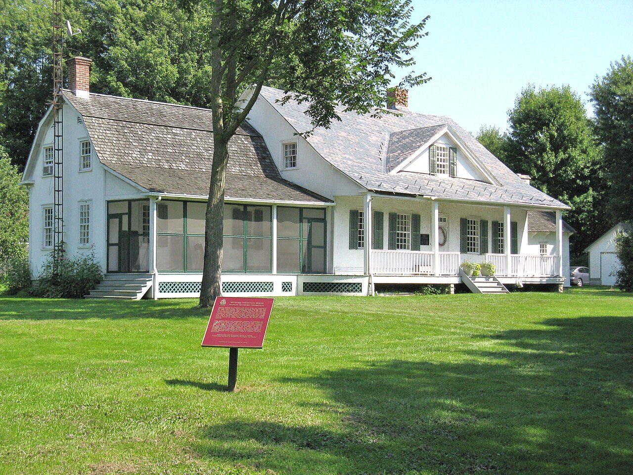
National Historic Site · 1784–1805Bethune-Thompson House / White House19730 John StreetPhoto: Yoho2001 · CC BY-SA 3.0 · Commons file
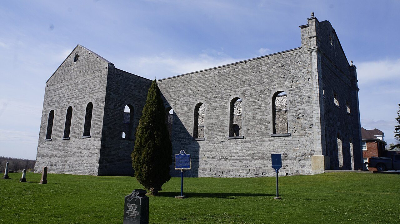 Ruin of St. Raphael's Roman Catholic Church · Photo: JFVoll · CC BY-SA 4.0
4historic places on the registers
History of South Glengarry · Canada’s heritage registers
History in South Glengarry goes back to 1784: Bethune-Thompson House / White House
The registers list 4 historic places inside South Glengarry, every one with the highest designation. For every 10,000 residents that makes 2.8, ahead of 89% of Canadian towns. As a municipality it dates, by Wikidata, from 1785, a date that can mark incorporation or a merger as well as a founding.
Historic places
4
2.8 per 10,000 residents
Highest designations
4
National Historic Sites and Classified Federal Heritage Buildings
Oldest building
1784
the first construction date on its record
Homes built before 1961
29%
typical town: 18%
In pictures
See 3 of South Glengarry’s 4 places with the highest designations
To start: Ruin of St. Raphael's Roman Catholic Church, and Bethune-Thompson House / White House. 3 of the places on South Glengarry’s heritage registers are pictured here; the others keep their register record. Of South Glengarry’s most honoured places, 3 are photographed.
Photos from Wikimedia Commons, each credited to its photographer with its licence; names open the place’s page. Tap a photo to step through them full screen.
The map
Where South Glengarry’s history is
Every place on the registers inside the town, by its designation.
Highest designations
Tap any dot to open that place’s own page; hovering shows its name.
The 4, by tier
4 Highest designations
What the map shows is the open record: the federal directory in full, and from provincial or municipal lists only the places Wikidata ties to an encyclopedia article.
Points from Wikidata (Parks Canada’s files carry none) and from Québec’s register, as mapped there.
Highest designations
4 places in South Glengarry with the highest designation
Their dates run from 1784, with Bethune-Thompson House / White House, to 1815. National Historic Sites and Classified Federal Heritage Buildings, Canada’s highest federal recognition. They were designated between 1921 and 1997. Each one opens its own page.
 Top
National Historic Site · 1784–1793Sir John Johnson HouseHighway 19Photo: P199 · CC BY-SA 3.0 · Commons file
 Top
National Historic Site · 1815–1822Ruin of St. Raphael's Roman Catholic Church20000 King's Road (County Road 18)Photo: JFVoll · CC BY-SA 4.0 · Commons file
National Historic Site · 1792–1793Glengarry HouseHighway 2
Homes by age
29% of South Glengarry’s homes are older than 1961, against a usual 18%
Half of the homes standing in South Glengarry today were built before 1981. From 2016 to 2021 South Glengarry added 2.6% of its homes, less than the typical town’s 4.1%. Homes built from 1961 to 1980 make up 26% of South Glengarry’s, about the typical 27%.
29%
Before 1961
26%
1961–80
27%
1981–2000
15%
2001–15
2.6%
2016–21
South GlengarryTypical town
2021 Census, private dwellings by period of construction (Statistics Canada); the typical town is the middle Canadian town of 2,500 or more.
Born here
South Glengarry’s people of the past, born 1794–1896
The years before Confederation gave 5 of the 9. Counting only births before 1914, there are 9. Best known is Samuel William Jacobs, with articles in 5 Wikipedia languages. Longest lived was Alexander Francis Macdonald, 95 years in all (1913).
Donald Aeneas MacDonell
Alexander Francis Macdonald
James Maclennan
John McLeod
David Murdoch McPherson
Samuel William Jacobs
Archibald John Macdonald
Paddy Sullivan
William Major
175017751800182518501875190019251950

Samuel William Jacobs1871–1938 · Canadian politician

Alexander Francis Macdonald1818–1913 · Canadian politician
JM
James Maclennan1833–1915 · Canadian politician
AM
Archibald John Macdonald1876–1938 · Canadian politician
WM
William Major1896–1966 · Canadian politician

David Murdoch McPherson1847–1915 · Canadian dairyman & cheesemaker
DM
Donald Aeneas MacDonell1794–1879 · Canadian politician

John McLeod1833–1879 · Canadian businessman and political figure from Ontario
Everyone born in South Glengarry → Born before 1914 (the page’s periods: Confederation to the First World War). Birthplaces from Wikidata, each checked against the person’s Wikipedia article.
Towns its size
South Glengarry has the most of 16 towns its size
Towns of 14,200 to 14,500 residents, by places on the registers.
South Glengarry4
The typical town its size has 0. 13 of them have nothing on the registers.
Neighbours
South Glengarry and its neighbours
| Town | People | Places | Highest | Oldest |
|---|---|---|---|---|
| South Glengarry | 14,355 | 4 | 4 | 1784 |
| Akwesasne | 2,562 | 0 | 0 | — |
| Cornwall | 54,346 | 2 | 1 | 1816 |
| Akwesasne (Part) 59 | 1,947 | 0 | 0 | — |
| Saint-Anicet | 2,854 | 1 | 1 | — |
In brief
South Glengarry in brief
South Glengarry’s homes from before 1961 come to 29%, against 18% in the typical town. There are 4 historic places in all, 4 with the highest designation. No town its size has more historic places: it leads the 16 nearest in population. Its people of the past include Samuel William Jacobs (1871), Alexander Francis Macdonald (1818) and James Maclennan (1833). Beyond that, the list grew between 1921 and 1997.
How to read these numbers
What this data can and can’t tell you
- Map points. Where a federal place sits on the map is Wikidata’s placing; the directory itself has no coordinates.
- The grade. History is described, not graded, for every Canadian town.
- The federal register. Federal places come from Parks Canada’s directory, which counts National Historic Sites, federal heritage buildings, stations and lighthouses; their statements are the register’s own.
- The tiers. Three tiers: the top for National Historic Sites, classified federal buildings and Québec’s classements, a second for the other federal designations, a third for provincial and municipal listings.
- Provincial and municipal lists. Provincial and municipal listings here come from Wikidata alone, since the provinces’ own registers can’t be reused; a listing needs an encyclopedia article to get a page.
- People and events. Persons of national historic significance come with no location; a town gets one only by birthplace (name and both life years agreeing) or by one of its own places that bears the name and whose record tells the story. Events, which can’t be tied, are left out.
- Protection. Being on these registers doesn’t mean a building can’t change. Federal designation commemorates; protection is provincial or municipal, and those lists aren’t open here.
Questions about South Glengarry’s history
What is the oldest building in South Glengarry?
Bethune-Thompson House / White House — its record dates it to 1784 (National Historic Site).
Which places in South Glengarry have the highest designation?
Bethune-Thompson House / White House, Sir John Johnson House, Glengarry House and Ruin of St. Raphael's Roman Catholic Church.
How old are the homes in South Glengarry?
The 2021 Census dates 29% of its homes before 1961 (18% in the typical town).
Contains information licensed under the Open Government Licence – Canada (Parks Canada).
Sources: Parks Canada, Directory of Federal Heritage Designations · Canadian Register of Historic Places (federal extract) · Wikidata (CC0) for map points, other names and articles · Statistics Canada, 2021 Census (homes by period of construction). Under the Statistics Canada Open Licence.
Adapted from Statistics Canada (Census of Population 2021, population estimates 2025, 2021 census boundaries) under the Statistics Canada Open Licence; this does not constitute an endorsement by Statistics Canada. Neighbourhood names in some cities © OpenStreetMap contributors (ODbL).