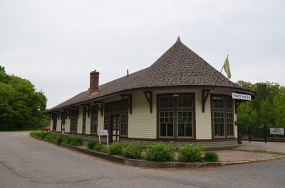
Canadian Pacific Railway Station, Parry Sound, Ontario · Photo: Mcbda99p · CC BY-SA 3.0
2historic places on the registers
History of Parry Sound · Canada’s heritage registers
In Parry Sound, 41% of homes go back before 1961
The typical town has 18%: Parry Sound has 2.3 times the share. Canada’s heritage registers list 2 historic places inside the town. On the list: a heritage railway station and a Recognized Federal Heritage Building. Of the dated places, Lighttower; Byng Inlet Front Range is the oldest, from 1890.
Every place on the registers inside the town, by its designation.
Other federal designations
Names show on hover, and a tap takes you to the place’s page.
The 2, by tier
2 Other federal designations
Federal designations come from Parks Canada’s directory; a province’s or a council’s own listing shows here only when Wikidata holds it and an encyclopedia covers it.
Points from Wikidata (Parks Canada’s files carry none) and from Québec’s register, as mapped there. One place, placed by its register’s municipality, has no point and isn’t on the map.
Other federal designations
2 more federal designations in Parry Sound
Here that means a Recognized Federal Heritage Building and a heritage railway station. Recognized Federal Heritage Buildings, heritage railway stations and lighthouses. The oldest, Lighttower; Byng Inlet Front Range, dates from 1890; the newest from 1907. Each one opens its own page.
18 designated places lie within 100 km of Parry Sound
Of 11 top designations nearby, Beausoleil Island is the closest, at 55 km. The earliest date is Sainte-Marie Among the Hurons Mission’s, 1639, 70 km away. They belong to 13 towns, chiefly Tay, Collingwood and Orillia.
The 12 nearest, within 100 km
LighthouseRecognized Federal Heritage Building · 1888–1890 · 44 km away, in The Archipelago
Beausoleil IslandNational Historic Site · 55 km away, in Georgian Bay
LighttowerClassified Federal Heritage Building · 1857–1859 · 92 km away, in Collingwood
Homes by age
41% of Parry Sound’s homes were built before 1961
Homes built from 1981 to 2000 make up just 16% of Parry Sound’s, against 23% in the typical town. From 2016 on, Parry Sound built 3.4% of its homes, near the typical 4.1%. More than half of Parry Sound’s housing predates 1981.
41%
Before 1961
29%
1961–80
16%
1981–2000
12%
2001–15
3.4%
2016–21
Parry SoundTypical town
2021 Census, private dwellings by period of construction (Statistics Canada); the typical town is the middle Canadian town of 2,500 or more.
Born here
6 lives that began in Parry Sound before 1914
In 1885 came the earliest, Allan Loney. 4 Wikipedias cover Gerald Carson, the most of anyone here. The line ends with Elmer Roy Smith (1913). John Brackenborough reached 96, the longest life here, ending in 1993.
Allan Loney
Oliver E. Crockford
John Brackenborough
Gerald Carson
Fred Bourdginon
Elmer Roy Smith
18501875190019251950
Gerald Carson1905–1956 · Canadian ice hockey defenceman
Allan Loney1885–1965 · Canadian ice hockey player
JB
John Brackenborough1897–1993 · Canadian ice hockey player
FB
Fred Bourdginon1906–1995 · Canadian ice hockey player
ES
Elmer Roy Smith1913–1989 · Canadian politician
OC
Oliver E. Crockford1893–1986 · Former reeve of Scarborough, Ontario, Canada
Everyone born in Parry Sound → Born before 1914 (the page’s periods: Confederation to the First World War). Birthplaces from Wikidata, each checked against the person’s Wikipedia article.
Towns its size
Parry Sound has the 3rd most of 16 towns its size
Towns of 7,500 to 7,700 residents, by places on the registers.
In Parry Sound, 41% of homes were built before 1961, against 18% in the typical town. All told, the registers hold 2 historic places. Of the 16 towns closest in size, just 2 have more historic places. Of its people of the past, the best known are Gerald Carson (1905), Allan Loney (1885) and John Brackenborough (1897). The rest is about typical: its places were designated between 1994 and 2008.
How to read these numbers
What this data can and can’t tell you
•
Protection. A National Historic Site designation recognises significance; it doesn’t by itself protect a building the federal government doesn’t own. Legal protection comes from provincial and municipal designations, whose own registers aren’t open data outside Québec.
•
The federal register. Parks Canada’s Directory of Federal Heritage Designations lists every National Historic Site, federal heritage building, heritage railway station and lighthouse; the Canadian Register of Historic Places adds their statements in English and French.
•
Provincial and municipal lists. Only Wikidata gives open access to listings on provincial and municipal registers outside Québec; without an article such a place is counted but not paged.
•
The tiers. Three tiers: the top for National Historic Sites, classified federal buildings and Québec’s classements, a second for the other federal designations, a third for provincial and municipal listings.
•
The grade. History is described, not graded, for every Canadian town.
•
Map points. Federal places get their map points from Wikidata, since Parks Canada’s files carry none; they are as mapped there.
•
People and events. The open directory puts its national historic persons nowhere, so a town shows one only on firm ground: a birth there, matched by name and life years, or a historic place there named for the person whose record says so. Events are left out.
Questions about Parry Sound’s history
How old are the homes in Parry Sound?
41% predate 1961, where the typical town has 18%.
How many historic places does Parry Sound have on the registers?
2 historic places in Parry Sound, from Canada’s heritage registers.
What is the oldest building in Parry Sound?
By its record, Lighttower; Byng Inlet Front Range, from 1890 (Recognized Federal Heritage Building).
Why might a heritage building in Parry Sound be missing here?
Provincial and municipal registers outside Québec aren’t open data. Wikidata knows one more listing in Parry Sound, but without an open description or an encyclopedia article it gets no page.
Contains information licensed under the Open Government Licence – Canada (Parks Canada).
Sources: Parks Canada, Directory of Federal Heritage Designations · Canadian Register of Historic Places (federal extract) · Wikidata (CC0) for map points, other names and articles · Statistics Canada, 2021 Census (homes by period of construction). Under the Statistics Canada Open Licence.

 Fed

