 Top
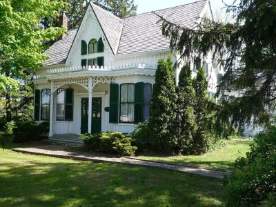
National Historic Site · 1808–1809Erland Lee (Museum) Home552 Ridge RoadPhoto: Kristenkerr · Public domain · Commons file
 Erland Lee (Museum) Home · Photo: Kristenkerr · Public domain
1historic place on the registers
History of Fruitland · Canada’s heritage registers
Fruitland: 1 historic place, with the highest designation
Fruitland’s entry is Erland Lee (Museum) Home (1808), a national historic site. Relative to its size Fruitland has 1.3 per 10,000 residents, more than 82% of Canadian towns.
Historic places
1
1.3 per 10,000 residents
Highest designations
1
National Historic Sites and Classified Federal Heritage Buildings
Oldest building
1808
the first construction date on its record
Homes built before 1961
18%
typical town: 18%
The map
Where Fruitland’s history is
Every place on the registers inside the town, by its designation.
Highest designations
Each dot is a place: point at it for the name, tap it for its page.
The 1, by tier
1 Highest designations
What the map shows is the open record: the federal directory in full, and from provincial or municipal lists only the places Wikidata ties to an encyclopedia article.
Points from Wikidata (Parks Canada’s files carry none) and from Québec’s register, as mapped there.
Highest designations
One place in Fruitland with the highest designation
National Historic Sites and Classified Federal Heritage Buildings, Canada’s highest federal recognition. Each one opens its own page.
Around the town
Nearest to Fruitland: Battle of Stoney Creek, 3.1 km away
The mix: 14 National Historic Sites, 6 provincial or municipal listings and a heritage railway station. By age, Battlefield House leads, from 1796, at 3.1 km. They belong to 13 towns, chiefly Corktown, Beasley and Battlefield.
The 12 nearest, within 25 km
| Battle of Stoney CreekNational Historic Site · 1813 · 3.1 km away, in Battlefield |
| Battlefield HouseOntario Heritage Trust easement · 1796 · 3.1 km away, in Battlefield |
| Hamilton WaterworksNational Historic Site · 1856–1860 · 6.8 km away, in Parkview West |
| Victoria HallNational Historic Site · 1887–1889 · 12 km away, in Corktown |
| Toronto, Hamilton & Buffalo Railway Station, Former, Hamilton, OntarioHeritage Railway Station · 1931–1934 · 12 km away, in Corktown |
| St. Paul's Presbyterian Church / Former St. Andrew's ChurchNational Historic Site · 1854–1858 · 12 km away, in Corktown |
| Sandyford PlaceNational Historic Site · 1856–1857 · 13 km away, in Durand |
| John Weir Foote ArmouryNational Historic Site · 1887–1889 · 13 km away, in Beasley |
| McQuesten House / WhitehernNational Historic Site · 1848–1849 · 13 km away, in Durand |
| AuchmarOntario Heritage Trust easement · 1855 · 13 km away, in Centremount |
| Christ's Church CathedralOntario Heritage Trust easement · 1873 · 13 km away, in Beasley |
| Former Hamilton Railway Station (Canadian National)National Historic Site · 1929–1932 · 13 km away, in Beasley |
Homes by age
18% of Fruitland’s homes are from 2016 to 2021 (4.1% is typical)
Half of the homes standing in Fruitland today were built before 2001. The busiest building years in Fruitland were from 1981 to 2000, which account for 28% of today’s homes. Like the typical town (18%), Fruitland has 18% of its homes from before 1961.
18%
Before 1961
21%
1961–80
28%
1981–2000
15%
2001–15
18%
2016–21
FruitlandTypical town
2021 Census, private dwellings by period of construction (Statistics Canada); the typical town is the middle Canadian town of 2,500 or more.
Towns its size
Fruitland has the 3rd most of 16 towns its size
Towns of 7,600 to 7,700 residents, by places on the registers.
Fruitland1
Only University and Fort Frances have more. Their median is 0. For 13, the registers list nothing.
Neighbours
Fruitland and its neighbours
| Town | People | Places | Highest | Oldest |
|---|---|---|---|---|
| Fruitland | 7,653 | 1 | 1 | 1808 |
| Highway Valley | 4,469 | 0 | 0 | — |
| Stoney Creek | 3,828 | 0 | 0 | — |
| Poplar Park | 3,031 | 0 | 0 | — |
| Guernsey | 3,808 | 0 | 0 | — |
| Eastdale | 2,703 | 0 | 0 | — |
| Westmeria | 2,646 | 0 | 0 | — |
In brief
Fruitland in brief
Housing in Fruitland includes 18% built before 1961, against 18% in the typical town. There are 1 historic place in all, one with the highest designation; Erland Lee (Museum) Home heads them. Just 2 towns of its size, out of 16, have more historic places. The other figures are unremarkable: one person of its past, Charles Napier Smith (1866); and its designation dates from 2002.
How to read these numbers
What this data can and can’t tell you
- The federal register. Every federal designation is in Parks Canada’s directory, and the Canadian Register of Historic Places gives most of them a bilingual statement of significance.
- People and events. Parks Canada’s open file gives its national historic persons no place. A town’s page names one only when the person was born there (matched by name and both life years) or one of its own historic places carries the name and its record speaks of them; national historic events stay off.
- Map points. Where a federal place sits on the map is Wikidata’s placing; the directory itself has no coordinates.
- Provincial and municipal lists. Only Wikidata gives open access to listings on provincial and municipal registers outside Québec; without an article such a place is counted but not paged.
- The tiers. The highest designations are National Historic Sites, Classified Federal Heritage Buildings and Québec’s classements; then come the other federal designations; then provincial and local listings.
- Protection. A National Historic Site designation recognises significance; it doesn’t by itself protect a building the federal government doesn’t own. Legal protection comes from provincial and municipal designations, whose own registers aren’t open data outside Québec.
- The grade. This page gives no grade; history doesn’t count toward a Canadian town’s letter.
Questions about Fruitland’s history
Which places in Fruitland have the highest designation?
Erland Lee (Museum) Home.
What is the oldest building in Fruitland?
Erland Lee (Museum) Home — its record dates it to 1808 (National Historic Site).
How old are the homes in Fruitland?
18% predate 1961, where the typical town has 18%.
Contains information licensed under the Open Government Licence – Canada (Parks Canada).
Sources: Parks Canada, Directory of Federal Heritage Designations · Canadian Register of Historic Places (federal extract) · Wikidata (CC0) for map points, other names and articles · Statistics Canada, 2021 Census (homes by period of construction). Under the Statistics Canada Open Licence.
Adapted from Statistics Canada (Census of Population 2021, population estimates 2025, 2021 census boundaries) under the Statistics Canada Open Licence; this does not constitute an endorsement by Statistics Canada. Neighbourhood names in some cities © OpenStreetMap contributors (ODbL).