 Top
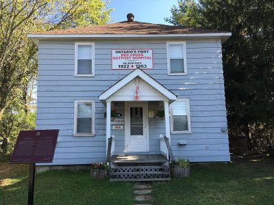
National Historic Site · 1914–1917Wilberforce Red Cross OutpostHighway 648, Burleigh RoadPhoto: Hollomis · CC BY-SA 4.0 · Commons file
 Wilberforce Red Cross Outpost · Photo: Hollomis · CC BY-SA 4.0
1historic place on the registers
History of Highlands East · Canada’s heritage registers
Highlands East’s 1 historic place is a top designation
Wilberforce Red Cross Outpost, from 1914, is Highlands East’s national historic site. As a municipality it dates, by Wikidata, from 2001, a date that can mark incorporation or a merger as well as a founding. Scaled to its population, Highlands East’s 2.3 per 10,000 residents beats 87% of Canadian towns.
Historic places
1
2.3 per 10,000 residents
Highest designations
1
National Historic Sites and Classified Federal Heritage Buildings
Oldest building
1914
the first construction date on its record
Homes built before 1961
24%
typical town: 18%
Through time
Highlands East, long ago
From before 1950 comes one old photograph of the town. A tap opens it at full size, with its credit.
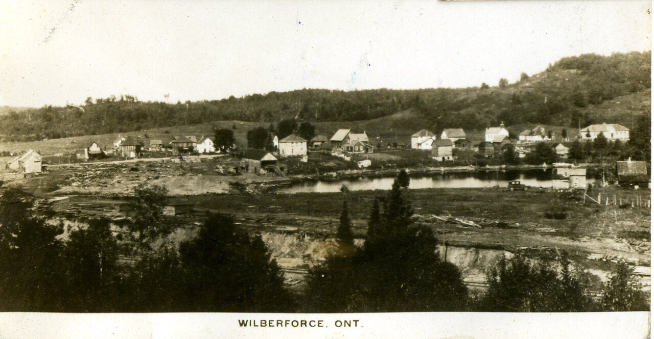 c. 1917
Public domain or CC0, made before 1950, from Wikimedia Commons; old views of places can be drawings, prints or maps of their time. Each credit opens the image’s page.
The map
Where Highlands East’s history is
Every place on the registers inside the town, by its designation.
Highest designations
Dots open their places’ pages; hover first to read the name.
The 1, by tier
1 Highest designations
Parks Canada’s Directory of Federal Heritage Designations lists the places the Government of Canada has recognized; outside Québec, provincial and municipal listings come only through Wikidata, and only those with an encyclopedia article get a page.
Points from Wikidata (Parks Canada’s files carry none) and from Québec’s register, as mapped there.
Highest designations
One place in Highlands East with the highest designation
National Historic Sites and Classified Federal Heritage Buildings, Canada’s highest federal recognition. Each one opens its own page.
Around the town
10 places of national importance within 100 km of Highlands East
Nearest comes Peterborough Petroglyphs, 48 km off, in North Kawartha. The earliest date is Mnjikaning Fish Weirs’s, 1650, 99 km away. They are 10 National Historic Sites, 4 provincial or municipal listings and 2 heritage railway stations.
The 12 nearest, within 100 km
| Peterborough PetroglyphsNational Historic Site · 48 km away, in North Kawartha |
| Canadian Pacific Railway Station, Havelock, OntarioHeritage Railway Station · 1914–1930 · 71 km away, in Havelock |
| Peterborough Drill Hall / ArmouryNational Historic Site · 1907–1910 · 79 km away, in Peterborough |
| Peterborough Lift LockNational Historic Site · 1896–1905 · 79 km away, in Peterborough |
| St. John the Evangelist Anglican ChurchOntario Heritage Trust easement · 1837 · 79 km away, in Peterborough |
| Cathedral of Saint Peter-in-ChainsDesignated heritage property (part IV) · 1837 · 79 km away, in Peterborough |
| Market Hall Performing Arts CentreDesignated heritage property (part IV) · 1890 · 79 km away, in Peterborough |
| Cox TerraceNational Historic Site · 1884–1885 · 79 km away, in Peterborough |
| Canal Lake Concrete Arch BridgeNational Historic Site · 1905–1906 · 80 km away, in Lindsay |
| Woodchester VillaOntario Heritage Trust easement · 1882 · 82 km away, in Bracebridge |
| Canadian National Railway Station, Huntsville, OntarioHeritage Railway Station · 1924–1925 · 83 km away, in Huntsville |
| Mazinaw PictographsNational Historic Site · 85 km away, in North Frontenac |
Homes by age
24% of Highlands East’s homes are older than 1961, against a usual 18%
More of Highlands East’s homes were built from 1961 to 1980 than in any other period: 28%. From 2016 to 2021 Highlands East added 3.2% of its homes, less than the typical town’s 4.1%. 19% of Highlands East’s homes date from 2001 to 2015, well above the typical 15%.
24%
Before 1961
28%
1961–80
25%
1981–2000
19%
2001–15
3.2%
2016–21
Highlands EastTypical town
2021 Census, private dwellings by period of construction (Statistics Canada); the typical town is the middle Canadian town of 2,500 or more.
Towns its size
Highlands East has the 2nd most of 16 towns its size
Towns of 4,400 to 4,400 residents, by places on the registers.
Highlands East1
Just one has more: Rossland. The middle one has 0. 13 of them have nothing on the registers.
Neighbours
Highlands East and its neighbours
| Town | People | Places | Highest | Oldest |
|---|---|---|---|---|
| Highlands East | 4,372 | 1 | 1 | 1914 |
| Haliburton Village | 8,100 | 0 | 0 | — |
In brief
Highlands East in brief
Before 1961: 24% of Highlands East’s homes, against 18% in the typical town. All told, the registers hold 1 historic place, one with the highest designation, Wilberforce Red Cross Outpost among them. Just one town of its size, out of 16, has more historic places. Otherwise the figures are ordinary: its designation dates from 2003.
How to read these numbers
What this data can and can’t tell you
- Map points. Federal places get their map points from Wikidata, since Parks Canada’s files carry none; they are as mapped there.
- The tiers. Three tiers: the top for National Historic Sites, classified federal buildings and Québec’s classements, a second for the other federal designations, a third for provincial and municipal listings.
- Protection. A National Historic Site designation recognises significance; it doesn’t by itself protect a building the federal government doesn’t own. Legal protection comes from provincial and municipal designations, whose own registers aren’t open data outside Québec.
- Provincial and municipal lists. Outside Québec, provinces’ and municipalities’ heritage registers aren’t open data; their places are known only through Wikidata items with a register number, and only those with an encyclopedia article get a page.
- The federal register. The federal list is complete and open: Parks Canada’s directory for the designations, the Canadian Register of Historic Places for what each one is and why it matters.
- The grade. History is described, not graded, for every Canadian town.
- People and events. National historic persons carry no place in the open file. They appear on a town’s page when born there (same name, same birth and death years) or when a historic place inside it carries their name and its record names them with their dates; national historic events don’t appear.
Questions about Highlands East’s history
Which places in Highlands East have the highest designation?
It is Wilberforce Red Cross Outpost.
What is the oldest building in Highlands East?
By its record, Wilberforce Red Cross Outpost, from 1914 (National Historic Site).
How old are the homes in Highlands East?
24% predate 1961, where the typical town has 18%.
Contains information licensed under the Open Government Licence – Canada (Parks Canada).
Sources: Parks Canada, Directory of Federal Heritage Designations · Canadian Register of Historic Places (federal extract) · Wikidata (CC0) for map points, other names and articles · Statistics Canada, 2021 Census (homes by period of construction). Under the Statistics Canada Open Licence.
Adapted from Statistics Canada (Census of Population 2021, population estimates 2025, 2021 census boundaries) under the Statistics Canada Open Licence; this does not constitute an endorsement by Statistics Canada. Neighbourhood names in some cities © OpenStreetMap contributors (ODbL).