
Where to go in Fort Erie: Fort Erie and more
Fort Erie’s list takes in 3 museums, 2 historic sites and a fort. There are 7 places to visit inside Fort Erie’s municipal boundary, plus one within 5 km of its edge. A day out reaches Niagara Falls, 23 km away.
Fort Erie’s big names
 FortFort Eriein townMuseumMuseumNiagara Railway Museumin townMuseumMuseumFort Erie Historical Museumin townMuseumMuseumFort Erie Railroad Museumin townZooZooSafari Niagarain townHistoric siteHistoric siteCaboosein town
Each has a page of its own: what it is, who runs it, the weather month by month and what else is near it.
Map of the places
The outermost point is Safari Niagara, at 9 km.
The dashed line is Fort Erie’s municipal boundary; orange marks its middle (where most people live). Numbers match the list below. © OpenStreetMap contributors · Statistics Canada 2021 outline
Sorted by kind
Forts or historic sites number 3, museums or galleries 3.
Green: inside Fort Erie. Grey: within 5 km of its edge.
The full list
International Boundary Line
The 7 inside Fort Erie come first, best known first; then the places within 5 km, close and well known first. Provincial and city parks are on the Outdoors page instead.
The wider area
 AttractionNiagara SkyWheel24 km northwest
 ZooBird Kingdom24 km northwestWater parkWater parkFallsview Indoor Waterpark24 km northwest
 ZooNiagara Parks Butterfly Conservatory29 km north
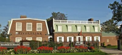 Art galleryRiverBrink Art Museum32 km north
 CathedralCathedral of St. Catherine of Alexandria38 km northwest
 BattlefieldBattle of Chippawa19 km north
 National historic site · Parks CanadaBrock’s Monument31 km north
Places well known beyond Fort Erie (Wikipedia articles in several languages, published visitor counts, or a Parks Canada property), close and famous first. Distances are straight lines from the middle of the town.
Quick answers on Fort Erie
Is there a Parks Canada property near Fort Erie?
None within 5 km. The nearest well-known one on our list is Brock’s Monument (Parks Canada), 31 km north.
What are the best-known days out near Fort Erie?
Further out, up to 40 km: Horseshoe Falls (23 km), Niagara SkyWheel (24 km), Bird Kingdom (24 km), Fallsview Indoor Waterpark (24 km).
How is this list made?
We merge OpenStreetMap, Wikidata, Statistics Canada’s ODCAF and the heritage registers into one list of museums, galleries, historic sites, forts, lighthouses, gardens, parks, waterfalls, ski hills, zoos and theme parks. To count, a historic building must show it takes visitors (hours, a fee, a website, a heritage operator or a Wikipedia article); hotels, restaurants and tours are dropped. Places inside the town’s 2021 outline come first, then those up to 5 km beyond it.
Places to visit: Canada publishes no open tourism list, so this one is assembled from OpenStreetMap (© OpenStreetMap contributors, ODbL), Wikidata (CC0), Statistics Canada’s ODCAF museums and galleries (2020, Open Government Licence – Canada), the federal and Québec heritage registers and CPCAD’s national parks, and it reflects what mappers and editors have recorded. Forts, houses, lighthouses and churches count only with a sign that visitors are welcome. Places sit in each town’s 2021 census outline; visitor counts are Wikidata’s latest, with their year.
Photos: each place’s Wikidata image, from Wikimedia Commons under the licence below (our copy, resized).
Photo credits (8)
- Fort Erie: Ernest Mettendorf, Public domain, Wikimedia Commons
- Niagara SkyWheel: Don-vip, CC BY-SA 3.0, Wikimedia Commons
- Bird Kingdom: Dennis G. Jarvis, CC BY-SA 2.0, Wikimedia Commons
- Niagara Parks Butterfly Conservatory: Jeff Hitchcock from Seattle, WA, USA, CC BY 2.0, Wikimedia Commons
- RiverBrink Art Museum: Diane Pellicone, CC BY-SA 3.0, Wikimedia Commons
- Cathedral of St. Catherine of Alexandria: Jfvoll, CC BY-SA 4.0, Wikimedia Commons
- Battle of Chippawa: XeresNelro, CC BY-SA 4.0, Wikimedia Commons
- Brock’s Monument: Jesse Davis, CC BY-SA 3.0, Wikimedia Commons
Adapted from Statistics Canada (Census of Population 2021, population estimates 2025, 2021 census boundaries) under the Statistics Canada Open Licence; this does not constitute an endorsement by Statistics Canada. Neighbourhood names in some cities © OpenStreetMap contributors (ODbL).