
National Historic Site · 1963Debert Palaeo-Indian Site
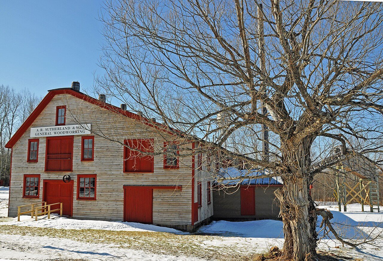 Sutherland Steam Mill Museum · Photo: Dennis G. Jarvis · CC BY-SA 2.0
4historic places on the registers
History of Colchester County, Subdivision B · Canada’s heritage registers
Heritage in Colchester County, Subdivision B: 4 historic places, one of the highest rank
On the list: 3 provincial or municipal listings. Its oldest building on the record is Fraser Octagon House, from 1857. Colchester County, Subdivision B has 1.9 for every 10,000 people, a higher rate than 85% of Canadian towns. Behind these stands one more local or provincial listing that only Wikidata records.
Historic places
4
1.9 per 10,000 residents
Highest designations
1
National Historic Sites and Classified Federal Heritage Buildings
Provincial and local listings
3
provincial and municipal listings with an encyclopedia article
Oldest building
1857
the first construction date on its record
Homes built before 1961
20%
typical town: 18%
In pictures
Look around Colchester County, Subdivision B: 2 photos
The set opens with Sutherland Steam Mill Museum and Balmoral Grist Mill Museum. Photos show 2 of the places Colchester County, Subdivision B’s registers name; the others show their record instead. Of the places pictured in Colchester County, Subdivision B, Balmoral Grist Mill Museum is the oldest, from 1874.
Photos from Wikimedia Commons, each credited to its photographer with its licence; names open the place’s page. Tap a photo to step through them full screen.
The map
Where Colchester County, Subdivision B’s history is
Every place on the registers inside the town, by its designation.
Highest designationsProvincial and local listings
Names show on hover, and a tap takes you to the place’s page.
The 4, by tier
1 Highest designations3 Provincial and local listings
Federal designations come from Parks Canada’s directory; a province’s or a council’s own listing shows here only when Wikidata holds it and an encyclopedia covers it.
Points from Wikidata (Parks Canada’s files carry none) and from Québec’s register, as mapped there.
Highest designations
One place in Colchester County, Subdivision B with the highest designation
National Historic Sites and Classified Federal Heritage Buildings, Canada’s highest federal recognition. Each one opens its own page.
Provincial and local listings
3 local listings in Colchester County, Subdivision B
Provincial and municipal listings that Wikidata records and an encyclopedia describes. Fraser Octagon House is the earliest, from 1857; the latest dates from 1958. Each one opens its own page.
 Local
Provincially Registered Property · 1874Balmoral Grist Mill MuseumPhoto: Derek Andrews · CC0 · Commons file
 Local
Provincially Registered Property · 1958Sutherland Steam Mill MuseumPhoto: Dennis G. Jarvis · CC BY-SA 2.0 · Commons file
Provincially Registered Property · 1857Fraser Octagon House
Homes by age
Colchester County, Subdivision B’s building boom came from 1981 to 2000: 33% of its homes
Like the typical town (18%), Colchester County, Subdivision B has 20% of its homes from before 1961. From 2016 on, Colchester County, Subdivision B built 4.3% of its homes, near the typical 4.1%. More than half of Colchester County, Subdivision B’s housing predates 2001.
20%
Before 1961
27%
1961–80
33%
1981–2000
17%
2001–15
4.3%
2016–21
Colchester County, Subdivision BTypical town
2021 Census, private dwellings by period of construction (Statistics Canada); the typical town is the middle Canadian town of 2,500 or more.
Born here
Natives of Colchester County, Subdivision B from 1813 to 1909
The record holds 8 people born here before 1914. By Wikipedia’s reach, Frank Harris Patterson leads, with 3 articles. Of the 8, 4 were born in the years before Confederation. Frank Harris Patterson lived longest, to 86, dying in 1976.
Thomas Dickson Archibald
William Blair
Wilbert David Dimock
Arthur Drysdale
Harold Putnam
John Brown Douglas
Frank Harris Patterson
James A. Langille
1800182518501875190019251950
FP
Frank Harris Patterson1890–1976 · Canadian judge
TA
Thomas Dickson Archibald1813–1890 · Canadian politician
WB
William Blair1836–1919 · Nova Scotia politician
WD
Wilbert David Dimock1846–1930 · Canadian politician

Arthur Drysdale1857–1922 · Canadian politician
HP
Harold Putnam1868–1945 · Canadian politician
JD
John Brown Douglas1871–1933 · Canadian politician from Nova Scotia
JL
James A. Langille1909–1979 · Canadian politician
Everyone born in Colchester County, Subdivision B → Born before 1914 (the page’s periods: Confederation to the First World War). Birthplaces from Wikidata, each checked against the person’s Wikipedia article.
Towns its size
Colchester County, Subdivision B has the 2nd most of 16 towns its size
Towns of 21,500 to 21,700 residents, by places on the registers.
Colchester County, Subdivision B4
Only Varennes has more. Their median is 0. 12 of them have nothing on the registers.
Neighbours
Colchester County, Subdivision B and its neighbours
| Town | People | Places | Highest | Oldest |
|---|---|---|---|---|
| Colchester County, Subdivision B | 21,578 | 4 | 1 | 1857 |
| Truro | 14,652 | 3 | 2 | 1874 |
| Millbrook 27 | 1,122 | 0 | 0 | — |
| Colchester County, Subdivision C | 14,211 | 0 | 0 | — |
In brief
Colchester County, Subdivision B in brief
The pre-1961 share of Colchester County, Subdivision B’s homes is 20%, against 18% in the typical town. In all there are 4 historic places, one with the highest designation, including Debert Palaeo-Indian Site. Just one town of its size, out of 16, has more historic places. Of its people of the past, the best known are Frank Harris Patterson (1890), Thomas Dickson Archibald (1813) and William Blair (1836). The rest is about typical: its one place was designated in 1972.
How to read these numbers
What this data can and can’t tell you
- The federal register. Parks Canada’s Directory of Federal Heritage Designations lists every National Historic Site, federal heritage building, heritage railway station and lighthouse; the Canadian Register of Historic Places adds their statements in English and French.
- Provincial and municipal lists. Provincial and municipal listings here come from Wikidata alone, since the provinces’ own registers can’t be reused; a listing needs an encyclopedia article to get a page.
- Protection. Federal recognition isn’t a planning control: buildings the federal government owns follow its heritage policy, while others are protected only by a provincial or municipal designation.
- People and events. The open directory puts its national historic persons nowhere, so a town shows one only on firm ground: a birth there, matched by name and life years, or a historic place there named for the person whose record says so. Events are left out.
- The tiers. Three tiers: the top for National Historic Sites, classified federal buildings and Québec’s classements, a second for the other federal designations, a third for provincial and municipal listings.
- Map points. Where a federal place sits on the map is Wikidata’s placing; the directory itself has no coordinates.
- The grade. History is described, not graded, for every Canadian town.
Questions about Colchester County, Subdivision B’s history
Which places in Colchester County, Subdivision B have the highest designation?
It is Debert Palaeo-Indian Site.
What is the oldest building in Colchester County, Subdivision B?
By its record, Fraser Octagon House, from 1857 (Provincially Registered Property).
Why might a heritage building in Colchester County, Subdivision B be missing here?
Provincial and municipal registers outside Québec aren’t open data. Wikidata knows one more listing in Colchester County, Subdivision B, but without an open description or an encyclopedia article it gets no page.
How old are the homes in Colchester County, Subdivision B?
Before 1961: 20% of its homes; the typical town has 18%.
Contains information licensed under the Open Government Licence – Canada (Parks Canada).
Sources: Parks Canada, Directory of Federal Heritage Designations · Canadian Register of Historic Places (federal extract) · Wikidata (CC0) for map points, other names and articles · Statistics Canada, 2021 Census (homes by period of construction). Under the Statistics Canada Open Licence.
Adapted from Statistics Canada (Census of Population 2021, population estimates 2025, 2021 census boundaries) under the Statistics Canada Open Licence; this does not constitute an endorsement by Statistics Canada. Neighbourhood names in some cities © OpenStreetMap contributors (ODbL).