 Local
Local historic place · 1836Sainte-Anne-du-Bocage ChapelPhoto: Dr Wilson · CC BY-SA 3.0 · Commons file
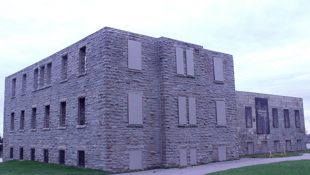 Couvent de Caraquet · Photo: Balaji Subramanian · CC BY-SA 3.0
4historic places on the registers
History of Caraquet · Canada’s heritage registers
Caraquet has 4 historic places on the registers
Only a few towns match Caraquet per resident: 8.7 for every 10,000, ahead of 97% of Canadian towns. The earliest construction date, 1836, belongs to Sainte-Anne-du-Bocage Chapel. Wikidata’s date for the municipality is 1903; it may record a founding, an incorporation or an amalgamation. On the list: 4 provincial or municipal listings.
Historic places
4
8.7 per 10,000 residents
Highest designations
0
National Historic Sites and Classified Federal Heritage Buildings
Provincial and local listings
4
provincial and municipal listings with an encyclopedia article
Oldest building
1836
the first construction date on its record
Homes built before 1961
18%
typical town: 18%
In pictures
Old and new: 4 photos and 5 old pictures of Caraquet
Begin with Couvent de Caraquet, then Sainte-Anne-du-Bocage Chapel. Photos show every place Caraquet’s registers name. 3 photographers took them.
 Sainte-Anne-du-Bocage Chapel
 Église Saint-Pierre-aux-Liens de Caraquet
 Collège de Caraquet Site+1See all photos
Photos from Wikimedia Commons, each credited to its photographer with its licence; names open the place’s page. Tap a photo to step through them full screen.
Through time
Caraquet from 1880 to 1920
On one line by date: 4 old photographs of the town and the oldest view of one of its historic places. The dots mark each picture’s year; tap one to enlarge it.
 1880
 1890
 1905
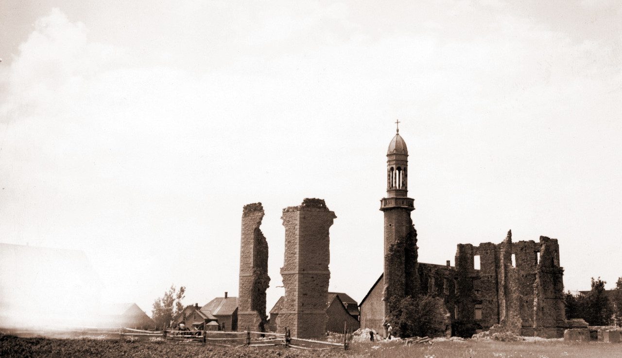 1915
 1920
Public domain or CC0, made before 1950, from Wikimedia Commons; old views of places can be drawings, prints or maps of their time. Each credit opens the image’s page.
The map
Where Caraquet’s history is
Every place on the registers inside the town, by its designation.
Provincial and local listings
Dots open their places’ pages; hover first to read the name.
The 4, by tier
4 Provincial and local listings
Parks Canada’s Directory of Federal Heritage Designations lists the places the Government of Canada has recognized; outside Québec, provincial and municipal listings come only through Wikidata, and only those with an encyclopedia article get a page.
Points from Wikidata (Parks Canada’s files carry none) and from Québec’s register, as mapped there.
Provincial and local listings
4 more places Caraquet or its province protects
Provincial and municipal listings that Wikidata records and an encyclopedia describes. The oldest, Sainte-Anne-du-Bocage Chapel, dates from 1836; the newest from 1860. Each one opens its own page.
 Local
Provincial heritage place · 1860Église Saint-Pierre-aux-Liens de CaraquetPhoto: Dr Wilson · CC BY-SA 3.0 · Commons file
 Local
Local historic placeCollège de Caraquet SitePhoto: Dr Wilson (photographie), auteur inconnu (sculpture). La sculpture est librement accessible devant un édifice public · CC BY-SA 3.0 · Commons file
 Local
Homes by age
Caraquet built the most from 1961 to 1980, 36% of today’s homes
Count back from today and half of Caraquet’s homes are older than 1981. From 2016 on, Caraquet built only 3% of its homes; the typical town built 4.1%. 18% of Caraquet’s homes predate 1961, close to the typical town’s 18%.
18%
Before 1961
36%
1961–80
31%
1981–2000
13%
2001–15
3%
2016–21
CaraquetTypical town
2021 Census, private dwellings by period of construction (Statistics Canada); the typical town is the middle Canadian town of 2,500 or more.
Born here
Lives begun in Caraquet between 1844 and 1896
Before 1914, 4 births here made the record. The widest known is Prosper E. Paulin: 3 Wikipedia editions. Longest lived was Frederick C. Young, 72 years in all (1968).
Prosper E. Paulin
Théotime Blanchard
Frederick T. B. Young
Frederick C. Young
1800182518501875190019251950
PP
Prosper E. Paulin1844– · Canadian politician

Théotime Blanchard1844–1911 · Canadian politician
FY
Frederick C. Young1896–1968 · Canadian politician
FY
Frederick T. B. Young1873–1940 · Canadian politician
Everyone born in Caraquet → Born before 1914 (the page’s periods: Confederation to the First World War). Birthplaces from Wikidata, each checked against the person’s Wikipedia article.
Towns its size
Caraquet has the 3rd most of 16 towns its size
Towns of 4,500 to 4,600 residents, by places on the registers.
Caraquet4
Just these have more: Neuville and Berthierville. The middle one has 0. 10 of them have nothing on the registers.
Neighbours
Caraquet and its neighbours
| Town | People | Places | Highest | Oldest |
|---|---|---|---|---|
| Caraquet | 4,572 | 4 | 0 | 1836 |
| Bas-Caraquet | 1,391 | 1 | 0 | — |
| Caraquet | 1,263 | 0 | 0 | — |
| Bertrand | 1,209 | 1 | 0 | — |
| Inkerman | 2,462 | 0 | 0 | — |
| Shippagan | 3,073 | 0 | 0 | — |
| Paquetville | 2,225 | 0 | 0 | — |
In brief
Caraquet in brief
Older stock first: 18% of homes in Caraquet were standing by 1961, against 18% in the typical town. All told, the registers hold 4 historic places. Just 2 towns of its size, out of 16, have more historic places. Prosper E. Paulin (1844), Théotime Blanchard (1844) and Frederick C. Young (1896) lead its people of the past.
How to read these numbers
What this data can and can’t tell you
- The grade. History is described, not graded, for every Canadian town.
- The tiers. Three tiers: the top for National Historic Sites, classified federal buildings and Québec’s classements, a second for the other federal designations, a third for provincial and municipal listings.
- Map points. Federal places get their map points from Wikidata, since Parks Canada’s files carry none; they are as mapped there.
- People and events. National historic persons carry no place in the open file. They appear on a town’s page when born there (same name, same birth and death years) or when a historic place inside it carries their name and its record names them with their dates; national historic events don’t appear.
- Protection. A National Historic Site designation recognises significance; it doesn’t by itself protect a building the federal government doesn’t own. Legal protection comes from provincial and municipal designations, whose own registers aren’t open data outside Québec.
- The federal register. The federal list is complete and open: Parks Canada’s directory for the designations, the Canadian Register of Historic Places for what each one is and why it matters.
- Provincial and municipal lists. Outside Québec, provinces’ and municipalities’ heritage registers aren’t open data; their places are known only through Wikidata items with a register number, and only those with an encyclopedia article get a page.
Questions about Caraquet’s history
How many historic places does Caraquet have on the registers?
4 historic places inside Caraquet, by the federal, Québec and Wikidata-known registers.
What is the oldest building in Caraquet?
Sainte-Anne-du-Bocage Chapel (Local historic place): the first construction date on its record is 1836.
Why might a heritage building in Caraquet be missing here?
Its province’s and council’s own lists can’t be reused here; 5 further listings in Caraquet show up only as Wikidata numbers.
How old are the homes in Caraquet?
18% predate 1961, where the typical town has 18%.
Contains information licensed under the Open Government Licence – Canada (Parks Canada).
Sources: Parks Canada, Directory of Federal Heritage Designations · Canadian Register of Historic Places (federal extract) · Wikidata (CC0) for map points, other names and articles · Statistics Canada, 2021 Census (homes by period of construction). Under the Statistics Canada Open Licence.
Adapted from Statistics Canada (Census of Population 2021, population estimates 2025, 2021 census boundaries) under the Statistics Canada Open Licence; this does not constitute an endorsement by Statistics Canada. Neighbourhood names in some cities © OpenStreetMap contributors (ODbL).