Porterville dates to 1864, and 3 of its places are on the National Register
More historic than 48% of U.S. towns · #165 of 847 in California. What drives it
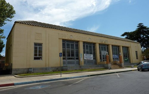
Most of Porterville was built recently: 7% of its homes predate 1940 and the median home dates from 1980. Its Register listings are the US Post Office-Porterville Main, the Zalud House and the First Congregational Church. Below: 18 old photos and papers, maps from 1891 on, and the census since 1880.
Founding year: Wikipedia. First post office: 1871.The full story ↓
History grade
What drives Porterville’s History grade
On its age, its old homes and the National Register, Porterville is more historic than 48% of U.S. towns, #165 of 847 in California. Its National Register listings hold the grade up; its share of homes from before 1940 pulls it down.
B−
HistoryA character grade: shown, never part of Porterville’s overall grade.
Few California towns list much on the Register (a typical California town has 0.0 per 10,000 residents, the U.S. 2.4), so Porterville’s 0.8 sits above most of its state (74% of California towns have fewer) while its 5 historic buildings outnumber those of 70% of U.S. towns.
How sure. Graded on any two of the three inputs instead, the letter would range from C to B. The pre-1940 share (±1.5 points) is firm at this size. Two sources give 1864.
Founding year: Wikipedia (other dates in Quick answers). Homes: Census ACS 2020–24. National Register: National Park Service, May 2026 list; each listing counted once (boundary changes and added documentation belong to their listing), and a historic district counts its contributing buildings. How TownRatings grades history →
What stands out about Porterville’s past
Read from the archive, the National Register and the record. The page puts what stands out first.
Nothing in the archives for these yearsWeddings on Main Street, storms, parades, school pictures, the old store. If it’s in your family album, it belongs here.
Lost post offices, old corners and places now gone
Porterville’s post office has been open since 1915. Another post office, Portersville, opened and closed inside today’s town.
Portersville
1871–1915
Porterville
1915–today
18701950today
Hamlets and corners on the map
MonacheNancevillePlanoPoncaRocheWestfield
Gone or out of use
Church of the NazarenechurchFirst Methodist ChurchchurchGoodhues CrossinglocalePorterville Army Air FieldmilitaryVine Street Public Schoolschool
US Post Offices dataset (Blevins & Helbock, CC0). Places and cemeteries from the USGS Geographic Names Information System (2021).
Every building
Porterville, building by building, 1891–1912
Fire insurance maps drew every building, what it was made of and what it was used for, so insurers could price the risk of fire. Pick a year, then a sheet.
During California's Spanish period, the San Joaquin Valley was considered a remote region of little value. Emigrants skirted the eastern foothills in the vicinity of Porterville as early as 1826. Swamps stretched out into the Valley floor lush with tall rushes or "tulare" as the Indigenous people called them.
Passages that mention Porterville, cut from the printed page as they were published.
History of Tulare County, California ... with biographical sketches1883 · page 172Read the page →
Read the text
he went and took the post-office with him. He died shortly and left the post-office in Porterville. That left the south side with¬ out any post-office; the river at that time in the winter was almost impassable from quicksand, and no bridge was then built.
Text read by machine from the scan; it may contain errors.
History of Tulare County, California ... with biographical sketches1883 · page 174Read the page →
Read the text
Porterville is situated on Tule River just as it leaves the foot-hills twenty-three miles southeast of Tulare City, and thirty miles from Visalia. It has a hotel, a church, two drug stores, two blacksmith shops, four general merchandise stores, a good school house with two departments, two livery stables and a first-class grist-mill run by water power.
Text read by machine from the scan; it may contain errors.
Scans and text from the Internet Archive. Books published in 1930 or earlier, which are in the public domain.
Timeline
Porterville, 1864 to 1987
Woven from the archive, old maps, post office records, the National Register and the people born here.
In 1864, according to Wikipedia’s history of the town. Porterville’s post office opened in 1871, and the census of 1880 counted 202 people here.
How does Porterville rank for history?
Porterville is more historic than 48% of U.S. towns, #165 of 847 in California. The History grade combines the town’s founding era, the share of homes built before 1940 and its National Register listings. It’s a character grade, so it isn’t part of the overall grade. How it works.
What is on the National Register in Porterville?
Three places: the US Post Office-Porterville Main (listed 1985), the Zalud House (1987) and the First Congregational Church (1999).
How old are the homes in Porterville?
7% of Porterville’s homes were built before 1940 (Census estimate, ±1.5 points), against a typical 3.4% for a California town; the median home was built in 1980.
Founding dates: Wikidata, Wikipedia, the U.S. post office records of Blevins & Helbock (CC0) and the Census. Homes by year built: Census ACS 2020–24. National Register of Historic Places: National Park Service (list of May 22, 2026). Old photos, postcards and papers: Wikimedia Commons, the Library of Congress and other public archives, credited on each item’s page. Maps: U.S. Geological Survey historical topographic maps (via Esri) and Sanborn fire-insurance maps (Library of Congress). History text and census tables: Wikipedia (CC BY-SA 4.0). Places that used to be: USGS Geographic Names Information System (2021).
From Wikimedia Commons (2), the Library of Congress (16), the National Register of Historic Places (3), Wikipedia, Wikidata and Wikipedia for famous people, U.S. Geological Survey historical maps, U.S. Census counts (via Wikipedia), the US Post Offices dataset (Blevins & Helbock), the USGS Geographic Names Information System, Sanborn fire insurance maps (Library of Congress) and old county and town histories (Internet Archive). Archive images are copied here with their credits and licenses, shown on each photo’s page. Refreshed monthly.


 c. 1910
 1914
 1936
 1936
 1936
 1936
 1936
 1936
 1936
 1936
 1936
 1938
 1940s
 1942
 1942
 1942
 1942
 1942