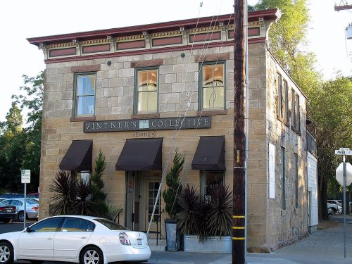
Napa’s post office opened in 1890, and 41 of its places are on the National Register
More historic than 65% of U.S. towns · #76 of 847 in California. What drives it
Most of Napa was built recently: 9% of its homes predate 1940 and the median home dates from 1974. 41 places in town are on the National Register, among them two historic districts with 298 buildings between them. Below: maps from 1886 on and the census since 1850.
The Napa post office opened in 1890, the earliest record of the town by name. Two smaller post offices, Napa City (1850) and Imola (1920), opened inside today’s city and later closed.
First census: 159 in 18502020 census: 79,246136 years
How historic is Napa?
B+
More historic than 65% of U.S. towns, on its age, its old homes and the National Register.
Founding year: the first Napa post office (Blevins & Helbock, CC0).The full story ↓
History grade
What drives Napa’s History grade
On its age, its old homes and the National Register, Napa is more historic than 65% of U.S. towns, #76 of 847 in California. Its National Register listings hold the grade up; its age pulls it down.
B+
HistoryA character grade: shown, never part of Napa’s overall grade.
Few California towns list much on the Register (a typical California town has 0.0 per 10,000 residents, the U.S. 2.4), so Napa’s 44.0 sits above most of its state (96% of California towns have fewer) while its 344 historic buildings outnumber those of 96% of U.S. towns.
How sure. Graded on any two of the three inputs instead, the letter would range from C to A−. The pre-1940 share (±1.1 points) is firm at this size. The founding year is the first post office, not a stated founding date.
Founding year: the first post office (other dates in Quick answers). Homes: Census ACS 2020–24. National Register: National Park Service, May 2026 list; each listing counted once (boundary changes and added documentation belong to their listing), and a historic district counts its contributing buildings. How TownRatings grades history →
What stands out about Napa’s past
Read from the archive, the National Register and the record. The page puts what stands out first.
The word "napa" is of Native American derivation and has been variously translated as "grizzly bear", "house", "motherland" or "fish". Of the many explanations of the name's origin, the most plausible seems to be that it is derived from the Patwin word napo, meaning "house".
Further adding confusion, Napa was originally spelled with two Ps: Nappa. There are maps and deeds dating back to the mid-1850s bearing this spelling. Shortly thereafter, the present spelling was adopted; the reasons for this are unclear.
Passages that mention Napa, cut from the printed page as they were published.
History of Napa and Lake Counties, California1881 · page 64Read the page →
Read the text
February 1, 1858, the following Act of the Legislature was approved: The Board of Supervisors of Napa County shall levy a tax, not to exceed one quarter of one per cent., for the purpose of constructing a public road from the city of Napa, by the way of Knight's Valley in Napa County, to Russian River Valley. Said road to pass up Napa Valley on the west side of Napa Creek ; and also for the purpose of constructing a public road from Napa City, running up the east side of Napa Creek to Clear Lake by the way of Chiles Canon.
Text read by machine from the scan; it may contain errors.
History of Napa and Lake couties, California...and biographical sketches..1881 · page 64Read the page →
Read the text
February 1, 1858, the following Act of the Legislature was approved : The Board of Supervisors of Napa County shall levy a tax, not to exceed one quarter of one per cent., for the purpose of constructing a public road from the city of Napa, by the way of Knight's Valley in Napa County, to Russian River Valley. Said road to pass up Napa Valley on the west side of Napa Creek ; and also for the purpose of constructing a public road from Napa City, running up the east side of Napa Creek to Clear Lake by the way of Chiles Canon.
Text read by machine from the scan; it may contain errors.
History of Solano and Napa counties, California, with biographical sketches of the leading men and women of the counties who have been identified with its growth and development from the early days to the present time1912 · page 146Read the page →
Read the text
In July, 1906, the San Francisco, Vallejo and Napa Valley Railroad Company was incorporated, took over the property of the Napa Valley Railroad Company and constructed the line from the northerly limits of the city of Napa to St. Helena, and the railroad since 1908 has been operated between St. Helena and Vallejo, a distance of thirty-four miles. Its passenger cars have a seating capacity for sixty-two people and are capable of maintaining a high rate of speed. At the present time a schedule of thirty trains a day is maintained. The effect this railroad has had upon the development of both
Text read by machine from the scan; it may contain errors.
History of Napa and Lake Counties, California1881 · page 105Read the page →
Read the text
This Act, it will be seen, transferred nearly a whole township from Lake to Napa County, including the mines at Knoxville. There was, previous to this, a Knoxville Township in Lake County, and subsequently a township of that name in Napa County. This Act provided further : The Board of Supervisors of Napa County shall order paid the claim of Lake County for the sum of $3,500, and the Auditor of said county of Napa shall draw a warrant for the same on the Treasurer of the said county, payable from the general fund, and the Treasurer of Napa County shall pay the same.
Text read by machine from the scan; it may contain errors.
Scans and text from the Internet Archive. Books published in 1930 or earlier, which are in the public domain.
Timeline
Napa, 1850 to 2002
Woven from the archive, old maps, post office records, the National Register and the people born here.
Every edition of the U.S. Geological Survey’s map of Napa. Tap a year, or press play to watch the town change.
1942Sonoma sheet · 1:62,500
U.S. Geological Survey historical topographic maps (public domain), via Esri’s collection of the scans. The red ring marks the center of Napa.
Every building
Napa, building by building, 1886–1910
Fire insurance maps drew every building, what it was made of and what it was used for, so insurers could price the risk of fire. Pick a year, then a sheet.
The Napa post office opened in 1890, the earliest record of the town by name (U.S. post office records).
How does Napa rank for history?
Napa is more historic than 65% of U.S. towns, #76 of 847 in California. The History grade combines the town’s founding era, the share of homes built before 1940 and its National Register listings. It’s a character grade, so it isn’t part of the overall grade. How it works.
What is on the National Register in Napa?
41 listings: 37 buildings, among them the Napa Opera House (listed 1973, the first), 2 historic districts, the Napa Abajo-Fuller Park Historic District and the Napa County Infirmary, with 298 contributing buildings, and 2 structures. 344 historic buildings in all.
How old are the homes in Napa?
9% of Napa’s homes were built before 1940 (Census estimate, ±1.1 points), against a typical 3.4% for a California town; the median home was built in 1974.
Founding dates: Wikidata, Wikipedia, the U.S. post office records of Blevins & Helbock (CC0) and the Census. Homes by year built: Census ACS 2020–24. National Register of Historic Places: National Park Service (list of May 22, 2026). Old photos, postcards and papers: Wikimedia Commons, the Library of Congress and other public archives, credited on each item’s page. Maps: U.S. Geological Survey historical topographic maps (via Esri) and Sanborn fire-insurance maps (Library of Congress). History text and census tables: Wikipedia (CC BY-SA 4.0). Places that used to be: USGS Geographic Names Information System (2021).
From Wikidata (6), the National Register of Historic Places (41), Wikipedia, Wikidata and Wikipedia for famous people, U.S. Geological Survey historical maps, U.S. Census counts (via Wikipedia), the US Post Offices dataset (Blevins & Helbock), the USGS Geographic Names Information System, Sanborn fire insurance maps (Library of Congress) and old county and town histories (Internet Archive). Archive images are copied here with their credits and licenses, shown on each photo’s page. Refreshed monthly.