More historic than 28% of U.S. towns · #353 of 847 in California. What drives it
Most of Forestville was built recently: 9% of its homes predate 1940 and the median home dates from 1966. Below: 1 old photo or paper, maps from 1911 on, and the census since 1880.
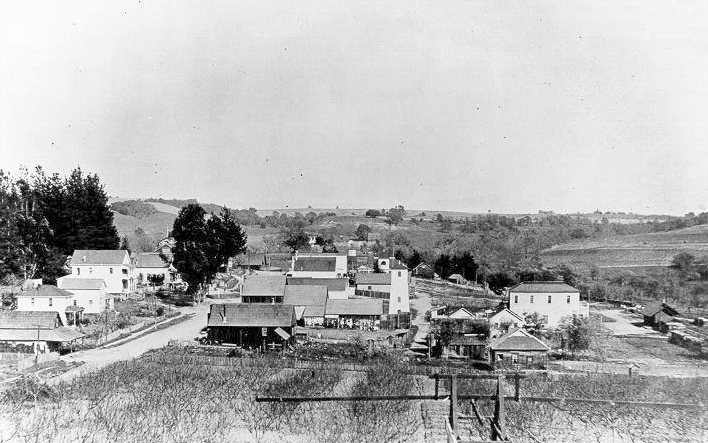
Founding year: the first Forestville post office (Blevins & Helbock, CC0).
History grade
What drives Forestville’s History grade
On its age, its old homes and the National Register, Forestville is more historic than 28% of U.S. towns, #353 of 847 in California. Its share of homes from before 1940 holds the grade up; its National Register listings pull it down.
C
HistoryA character grade: shown, never part of Forestville’s overall grade.
Few California towns list much on the Register (a typical California town has 0.0 per 10,000 residents, the U.S. 2.4), so Forestville’s 0.0 sits below most of its state (31% of California towns have fewer) while its 0 listings outnumber those of 23% of U.S. towns.
How sure. Graded on any two of the three inputs instead, the letter would range from C− to C. The pre-1940 share is a Census survey estimate (±5.1 points). The founding year is the first post office, not a stated founding date.
Founding year: the first post office (other dates in Quick answers). Homes: Census ACS 2020–24. National Register: National Park Service, May 2026 list; each listing counted once (boundary changes and added documentation belong to their listing), and a historic district counts its contributing buildings. How TownRatings grades history →
What stands out about Forestville’s past
Read from the archive, the National Register and the record. The page puts what stands out first.
Wikipedia doesn’t have a history of Forestville yet. The photos, dates and memories neighbors add here are how it gets written.
Forestville is a census-designated place (CDP) in Sonoma County, California, United States. It was settled during the late 1860s and was originally spelled Forrestville after one of its founders; the spelling was soon standardized with one "r". The population was 3,264 at the 2020 census, down from 3,293 at the 2010 census. By 1900, the community was known for attracting writers and artists and had a bohemian reputation. The small town has a limited number of businesses.
Its first post office opened in 1872. Its population held steady between the last two censuses: 3,293 in 2010, 3,264 in 2020.
Intro from Wikipedia. Population: U.S. Census Bureau.
From the old history books
What they wrote about Forestville, 1889–1911
Passages that mention Forestville, cut from the printed page as they were published.
History of Sonoma County, California, with biographical sketches of the leading men and women of the county, who have been identified with its growth and development from the early days to the present time1911 · page 835Read the page →
Read the text
His acquaintance with Sonoma county began in 1865, when he came back to the settlement that later became Forestville and established himself in the blaclcsmith business, his shop being the first in this section of the state, and naturally it received a large patronage, as tliose were the days before the coming of the railroad and horses were in constant use. From that time until his death, in 1889, he continued to maintain the blacksmith shop, besides which he owned a fruit ranch of forty acres. As one of the early settlers in this community and a man of unusual progress and perseverance he took the lead in upbuilding
Text read by machine from the scan; it may contain errors.
An illustrated history of Sonoma County, California. Containing a history of the county of Sonoma from the earliest period of its occupancy to the present time1889 · page 558Read the page →
Read the text
until 1857, when he came to Sonoma Valley, and purchased 300 acres of land frym Judge Moran, situated in Green Valley, Analy Township, on the Santa Rosa and Forestville road, about one and a half miles south of Forestville, in the Redwood school district. Here Mr. Ross has since resided, devoting hiiflself principally to agricultural pursuits. The most of his land
Text read by machine from the scan; it may contain errors.
History of Sonoma County, California, with biographical sketches of the leading men and women of the county, who have been identified with its growth and development from the early days to the present time1911 · page 190Read the page →
Read the text
for a name is when he wrote "Analy," for his sister Anna. It is a pretty name, well fitting the tract that it designates. With the exception of the district bordering Marin county and the sea, the entire township is a park and the portion around Sebastopol, Graton in Green valley, and Forestville, is a veritable "fruitland." The Petaluma and Santa Rosa Railway enters Analy at its southeastern corner, near Stony Point, and extends to Forestville. This practically gives to the entire length of the township hourly electric trains. Where in all the state has there been a more complete fitting of the natural and the
Text read by machine from the scan; it may contain errors.
An illustrated history of Sonoma County, California. Containing a history of the county of Sonoma from the earliest period of its occupancy to the present time1889 · page 668Read the page →
Read the text
horticulturist is well known. Of his original land he is now the owner of 108 acres. This land is situated on the east side of the valley, near the Sebastopol and Forestville road, in the Oak Grove school district, four miles northwest of Sebastopol and two miles south of Forestville. The greater portion of his land is devoted to hay, grain and stock-raising, but he
Text read by machine from the scan; it may contain errors.
Scans and text from the Internet Archive. Books published in 1930 or earlier, which are in the public domain.
Timeline
Forestville, 1872 to 1942
Woven from the archive, old maps, post office records, the National Register and the people born here.
Nothing in the archives for these yearsWeddings on Main Street, storms, parades, school pictures, the old store. If it’s in your family album, it belongs here.
Forestville’s post office has been open since 1872.
Hamlets and corners on the map
Mirabel HeightsMirabel ParkRio Dell
US Post Offices dataset (Blevins & Helbock, CC0). Places and cemeteries from the USGS Geographic Names Information System (2021).
Questions about Forestville’s history
What year was Forestville founded?
The Forestville post office opened in 1872, the earliest record of the town by name (U.S. post office records).
How does Forestville rank for history?
Forestville is more historic than 28% of U.S. towns, #353 of 847 in California. The History grade combines the town’s founding era, the share of homes built before 1940 and its National Register listings. It’s a character grade, so it isn’t part of the overall grade. How it works.
How old are the homes in Forestville?
9% of Forestville’s homes were built before 1940 (Census estimate, ±5.1 points), against a typical 3.4% for a California town; the median home was built in 1966.
Founding dates: Wikidata, Wikipedia, the U.S. post office records of Blevins & Helbock (CC0) and the Census. Homes by year built: Census ACS 2020–24. National Register of Historic Places: National Park Service (list of May 22, 2026). Old photos, postcards and papers: Wikimedia Commons, the Library of Congress and other public archives, credited on each item’s page. Maps: U.S. Geological Survey historical topographic maps (via Esri) and Sanborn fire-insurance maps (Library of Congress). History text and census tables: Wikipedia (CC BY-SA 4.0). Places that used to be: USGS Geographic Names Information System (2021).
From Wikimedia Commons (5), U.S. Geological Survey historical maps, U.S. Census counts (via Wikipedia), the US Post Offices dataset (Blevins & Helbock), the USGS Geographic Names Information System, Sanborn fire insurance maps (Library of Congress) and old county and town histories (Internet Archive). Archive images are copied here with their credits and licenses, shown on each photo’s page. Refreshed monthly.


 2021
 2021
 2009
 2007


