Eureka dates to 1850, and 32% of its homes were built before 1940
More historic than 86% of U.S. towns · #15 of 847 in California. What drives it
19 places in town are on the National Register, among them a historic district with 154 buildings. Below: 5 old photos and papers, maps from 1886 on, and the census since 1860.
Founding year: Wikidata. First post office: 1852.The full story ↓
History grade
What drives Eureka’s History grade
On its age, its old homes and the National Register, Eureka is more historic than 86% of U.S. towns, #15 of 847 in California. Its National Register listings hold the grade up; its age pulls it down.
A
HistoryA character grade: shown, never part of Eureka’s overall grade.
Few California towns list much on the Register (a typical California town has 0.0 per 10,000 residents, the U.S. 2.4), so Eureka’s 66.5 sits above most of its state (98% of California towns have fewer) while its 173 historic buildings outnumber those of 92% of U.S. towns.
How sure. Graded on any two of the three inputs instead, the letter would range from B to A+. The pre-1940 share is a Census survey estimate (±3.3 points). Two sources give 1850.
Founding year: Wikidata (other dates in Quick answers). Homes: Census ACS 2020–24. National Register: National Park Service, May 2026 list; each listing counted once (boundary changes and added documentation belong to their listing), and a historic district counts its contributing buildings. How TownRatings grades history →
What stands out about Eureka’s past
Read from the archive, the National Register and the record. The page puts what stands out first.
National Park Service, National Register of Historic Places. Photos from Wikimedia Commons, credited on each place’s page.
Every building
Eureka, building by building, 1886–1920
Fire insurance maps drew every building, what it was made of and what it was used for, so insurers could price the risk of fire. Pick a year, then a sheet.
The Wiyot people lived in Jaroujiji (Wiyot for 'where you sit and rest'), now known as Eureka, for thousands of years before European arrival. Their traditional coastal homeland ranges from the Little River in the north to Bear River Ridge in the south, including the entire coastline of Humboldt Bay, stretching inland to the mountains. The Wiyot people are particularly known for their basketry and fishery management. An extensive collection of intricate basketry of the area's indigenous groups exists in the Clarke Historical Museum in Old Town Eureka.
Mad River, and on it is a saw-mill that will cut 40.000 feet ™>r day He has a railroad seven miles Ion? to transport the lumber to lighten on Mad River Slough, whence his steamer J* hauls them to Eureka for shipment. He also has a sawmU1 in Eureka with a capacity of 30.000 feet per day and oeto the logs for it by hauling them seven miles on his railroad Jrom Mad River Slough where they are put in the water and de in a raft and towed with his steamer Ada to Eureka.
Text read by machine from the scan; it may contain errors.
History of Humboldt County, California1915 · page 329Read the page →
Read the text
For one summer season he had charge of the Crescent City and Grants Pass Railroad. In 1907 he located the Trinity state highway, from Salt creek to Alad river, a stretch of twenty-eight miles. He has made plans for a gravity system of water supply for the city of Eureka, to obtain pure city water from the Mad river as well as electric power, at a cost of one million dollars. In 1898 he published a state map, which he revised in 1904; besides which he published a map of the city of Eureka and several maps of Humboldt county, and also of several counties in California. The
Text read by machine from the scan; it may contain errors.
History of Humboldt County, California1915 · page 1074Read the page →
Read the text
he returned to Eureka in 1903, and went to work as a millwright under his brother George. At the same time he joined fire company No. 5, in Eureka, and commenced to take a great interest in the subject of fire protection.
Text read by machine from the scan; it may contain errors.
Scans and text from the Internet Archive. Books published in 1930 or earlier, which are in the public domain.
Timeline
Eureka, 1850 to 1998
Woven from the archive, old maps, post office records, the National Register and the people born here.
Nothing in the archives for these yearsWeddings on Main Street, storms, parades, school pictures, the old store. If it’s in your family album, it belongs here.
In 1850, according to Wikidata. Eureka’s post office opened in 1852, and the census of 1860 counted 612 people here.
How does Eureka rank for history?
Eureka is more historic than 86% of U.S. towns, #15 of 847 in California. The History grade combines the town’s founding era, the share of homes built before 1940 and its National Register listings. It’s a character grade, so it isn’t part of the overall grade. How it works.
What is on the National Register in Eureka?
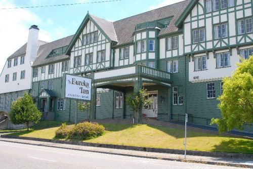
19 listings: 18 buildings, among them the E. Janssen Building (listed 1973, the first), and 1 historic district, the Eureka Historic District, with 154 contributing buildings. 173 historic buildings in all.
How old are the homes in Eureka?
32% of Eureka’s homes were built before 1940 (Census estimate, ±3.3 points), against a typical 3.4% for a California town; the median home was built in 1954.
Founding dates: Wikidata, Wikipedia, the U.S. post office records of Blevins & Helbock (CC0) and the Census. Homes by year built: Census ACS 2020–24. National Register of Historic Places: National Park Service (list of May 22, 2026). Old photos, postcards and papers: Wikimedia Commons, the Library of Congress and other public archives, credited on each item’s page. Maps: U.S. Geological Survey historical topographic maps (via Esri) and Sanborn fire-insurance maps (Library of Congress). History text and census tables: Wikipedia (CC BY-SA 4.0). Places that used to be: USGS Geographic Names Information System (2021).
From Wikimedia Commons (2), the Library of Congress (18), Wikidata (3), the National Register of Historic Places (19), Wikipedia, Wikidata and Wikipedia for famous people, U.S. Geological Survey historical maps, U.S. Census counts (via Wikipedia), the US Post Offices dataset (Blevins & Helbock), the USGS Geographic Names Information System, Sanborn fire insurance maps (Library of Congress) and old county and town histories (Internet Archive). Archive images are copied here with their credits and licenses, shown on each photo’s page. Refreshed monthly.





 2013
 2012
 2012
 2012
 2012
 2012
 2012
 2012
 2012
 2012
 2012
 2012
 2012
 2012
 2012


