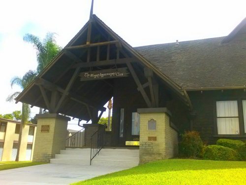
Corona dates to 1886, and 6 of its places are on the National Register
More historic than 43% of U.S. towns · #195 of 847 in California. What drives it
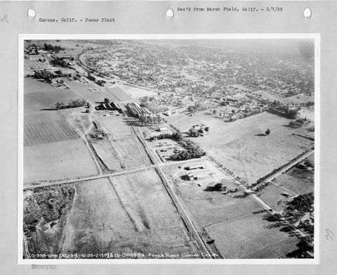
Most of Corona was built recently: 3% of its homes predate 1940 and the median home dates from 1991. 6 places in town are on the National Register, among them two historic districts with 15 buildings between them. Below: 8 old photos and papers, maps from 1900 on, and the census since 1900.
Founding year: Wikipedia. First post office: 1887.The full story ↓
History grade
What drives Corona’s History grade
On its age, its old homes and the National Register, Corona is more historic than 43% of U.S. towns, #195 of 847 in California. Its National Register listings hold the grade up; its share of homes from before 1940 pulls it down.
C+
HistoryA character grade: shown, never part of Corona’s overall grade.
Among the 400 U.S. cities of 100,000 or more, Corona ranks #256 on History.
Few California towns list much on the Register (a typical California town has 0.0 per 10,000 residents, the U.S. 2.4), so Corona’s 1.3 sits above most of its state (78% of California towns have fewer) while its 21 historic buildings outnumber those of 80% of U.S. towns.
Newer cities are common at Corona’s size: in the typical U.S. city of 100,000 or more, 5% of homes predate 1940.
How sure. Graded on any two of the three inputs instead, the letter would range from C− to B. The pre-1940 share (±0.6 points) is firm at this size. Two sources give 1886.
Founding year: Wikipedia (other dates in Quick answers). Homes: Census ACS 2020–24. National Register: National Park Service, May 2026 list; each listing counted once (boundary changes and added documentation belong to their listing), and a historic district counts its contributing buildings. How TownRatings grades history →
What stands out about Corona’s past
Read from the archive, the National Register and the record. The page puts what stands out first.
US Post Offices dataset (Blevins & Helbock, CC0). Places and cemeteries from the USGS Geographic Names Information System (2021).
Every building
Corona, building by building, 1900–1911
Fire insurance maps drew every building, what it was made of and what it was used for, so insurers could price the risk of fire. Pick a year, then a sheet.
Prior to the late eighteenth century, the area was primarily inhabited by the Tongva and Payómkawichum, who lived in a series of villages throughout the area. What is now Corona stood at the southeastern extent of Tovaangar, or the Tongva world, and at the northern edge of Payómkawichum territory.
The primary settlement in the area was the village of Paxauxa, which was established along the banks of the Temescal Creek at about where Corona is situated today. The settlement was shared by both the Tongva and Payómkawichum people. Cooperation and marriage between the two villages was common. High above the city of Corona, the village of Pamajam was also located in a small valley of the Santa Ana Mountains.
Passages that mention Corona, cut from the printed page as they were published.
History of Riverside County, California1912 · page 563Read the page →
Read the text
Going to Perris Valley in 1898 with his sons Mr. Chase purchased land and established the station of Ethanac, sunk many wells and built a steam electric plant to supply power to pump the water, with the idea of establishing a dairy colony. Corona being short of water, bought land near there, laid pipe lines to Corona and later bought out the interests of Mr. Chase and sons, they taking in part pavment some stock in the Temescal Water Company of Corona. This led them to go to Corona and buy land,
Text read by machine from the scan; it may contain errors.
History of Riverside County, California1912 · page 545Read the page →
Read the text
service in different eastern states. Upon resigning his position he came to California and for some time he was engaged as a station agent in the employ of the Santa Fe Railroad Company at different places, coming in that capacity in 1903 to Corona, where ever since he has made his home. A satisfactory service of three years as manager of the Queen Colony Fruit Exchange laid the foundation of the success attained by Mr. Roberts in the domain of horticulture. In December of 1909
Text read by machine from the scan; it may contain errors.
Scans and text from the Internet Archive. Books published in 1930 or earlier, which are in the public domain.
Timeline
Corona, 1886 to 1987
Woven from the archive, old maps, post office records, the National Register and the people born here.
Nothing in the archives for these yearsWeddings on Main Street, storms, parades, school pictures, the old store. If it’s in your family album, it belongs here.
In 1886, according to Wikipedia’s history of the town. Corona’s post office opened in 1887, and the census of 1900 counted 1,434 people here.
How does Corona rank for history?
Corona is more historic than 43% of U.S. towns, #195 of 847 in California. The History grade combines the town’s founding era, the share of homes built before 1940 and its National Register listings. It’s a character grade, so it isn’t part of the overall grade. How it works.
What is on the National Register in Corona?
6 listings: 4 buildings, among them the Carnegie, Andrew, Library (listed 1977, the first), and 2 historic districts, the Grand Boulevard Historic District and the Corona Foothill Ranch, with 15 contributing buildings. 21 historic buildings in all.
How old are the homes in Corona?
3% of Corona’s homes were built before 1940 (Census estimate), against a typical 3.4% for a California town; the median home was built in 1991.
Founding dates: Wikidata, Wikipedia, the U.S. post office records of Blevins & Helbock (CC0) and the Census. Homes by year built: Census ACS 2020–24. National Register of Historic Places: National Park Service (list of May 22, 2026). Old photos, postcards and papers: Wikimedia Commons, the Library of Congress and other public archives, credited on each item’s page. Maps: U.S. Geological Survey historical topographic maps (via Esri) and Sanborn fire-insurance maps (Library of Congress). History text and census tables: Wikipedia (CC BY-SA 4.0). Places that used to be: USGS Geographic Names Information System (2021).
From Wikimedia Commons (15), the Library of Congress (1), Wikidata (1), the National Register of Historic Places (6), Wikipedia, Wikidata and Wikipedia for famous people, U.S. Geological Survey historical maps, U.S. Census counts (via Wikipedia), the US Post Offices dataset (Blevins & Helbock), the USGS Geographic Names Information System, Sanborn fire insurance maps (Library of Congress) and old county and town histories (Internet Archive). Archive images are copied here with their credits and licenses, shown on each photo’s page. Refreshed monthly.


 1917
 1917
 1917
 1917
 1917
 1917
 2011
 2011
 2011
 2010
 2008
 2008
 2008
 2006