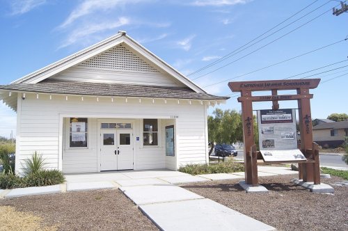
More weak spots than strong ones. Castroville grades D overall, better than 5% of U.S. towns, and ranks 699th of 841 in California. Its weakest is cost of living — the typical home is worth about $677K, 7 years of the Salinas metro’s $97K median household income. It also trails on health: CDC estimates put its residents' health behind 77% of the country. Hazard risk is weaker too — FEMA rates its natural-hazard risk higher than 90% of U.S. communities, with earthquakes at the top. Where it does best is walkability (B+): it is easier to get around on foot or by transit than 75% of U.S. towns. Castroville Japanese Language School is on the National Register of Historic Places. The town’s peak summer temperature is 66°F, below both California’s towns (89°F) and U.S. towns (85°F).
Figures: home values, Zillow · incomes, Census ACS, 2020–24 · health, CDC PLACES · FEMA National Risk Index · National Register of Historic Places · NOAA normals, 1991–2020.
Of the losses FEMA expects in Castroville, 71% come from earthquakes and 26% from inland flooding. Households here have drawn federal disaster aid in 3 declared disasters, most recently in 2023. Paid flood insurance claims in the town since 1995: 4.
28% of Castroville adults 18 to 64 have no health insurance. The town does better than the California average on 2 of 32 CDC measures and worse on 18. Two figures for adults in the town: 36% worry about having enough food, 66% had a checkup this year.
7.5% of workers do their job from home in Castroville. Only 8% of working residents stay in Castroville for work; the rest commute out. Jobs based in Castroville grew to 1,795 in 2023, 1,135 more than in 2013. The top destinations are Salinas (16%), San Jose (7%) and Monterey (7%).
8%work in town
Castroville
California towns
U.S. towns
Below the poverty line
18%
10%
9.6%
Work from home
7.5%
14%
11%
Average trip to work
27 minutes
28 minutes
25 minutes
Median household income
$89,000
$95,000
$80,000
Where working residents work
In Castroville8%
Salinas16%
San Jose7%
Monterey7%
Watsonville5%
14 mi
median commute distance
1,795
jobs based in Castroville
A commuter town
jobs vs. working residents
B+
Walkability grade: more walkable than 75% of U.S. towns
The Monterey Wfo weather station, 13 miles away, records that about 2 days a year reach 90°, fewer than in 96% of U.S. towns. January nights average 42.6°, milder than in 96% of U.S. towns; July afternoons average 66.3°.
The January low in Castroville is 43°F. The seasons here: warm winters, cool summers, with very little rain. Snow is almost unheard of.
For Castroville, the midpoint rent is $1,948 a month. The typical home value here is about $677,000, down 0.5% in a year, 11% below the California typical home. The share of households in Castroville who own their home: 46%.
92% of working residents leave Castroville for work
Where Castroville’s working residents go each day. Line width shows the share.
1,795jobs based in Castroville
8%of working residents work in town
14 mimedian commute distance
Census LEHD 2023
About Castroville
Unincorporated community in California, United States
Castroville is an unincorporated town and census-designated place (CDP) in Monterey County, California, United States. At the time of the 2020 census the population was 7,515, up from 6,481 in 2010. Castroville is known for its artichoke crop and for the annual Castroville Artichoke Festival, leading to its nickname as the "Artichoke Center of the World". The community's origins lie in Rancho Bolsa Nueva y Moro Cojo, a Mexican-era rancho granted to the Castro family of Californio rancheros. Following the American Conquest of California, Juan Bautista Castro founded Castroville in 1863.
Castroville grades D overall, better than 5% of U.S. towns and #699 of 841 in California. It grades C− for health and C for schools. Hazard risk is its weak spot, with a D.
Is Castroville, CA expensive?
Yes. Cost of living, which also weighs rents, property taxes and how many households pay 30% or more of their income for housing, grades D.
What is Castroville, CA known for?
2 notable people were born here, including James J. Keating and James W. Silliman.


 13 mi
 14 mi
 32 mi
 17 mi
 13 mi


