Calexico’s post office opened in 1902, and 2 of its places are on the National Register
More historic than 24% of U.S. towns · #392 of 847 in California. What drives it
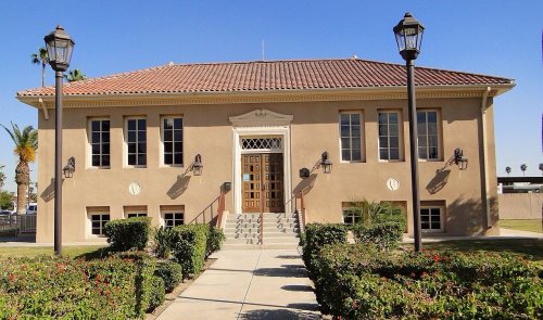
Its Register listings are the US Inspection Station-Calexico and the Calexico Carnegie Library. Most of Calexico was built recently: 2% of its homes predate 1940 and the median home dates from 1993. Below: 5 old photos and papers, maps from 1910 on, and the census since 1910.
Founding year: the first Calexico post office (Blevins & Helbock, CC0). Wikidata: 1908.The full story ↓
History grade
What drives Calexico’s History grade
On its age, its old homes and the National Register, Calexico is more historic than 24% of U.S. towns, #392 of 847 in California. Its National Register listings hold the grade up; its age pulls it down.
C−
HistoryA character grade: shown, never part of Calexico’s overall grade.
Few California towns list much on the Register (a typical California town has 0.0 per 10,000 residents, the U.S. 2.4), so Calexico’s 0.8 sits above most of its state (74% of California towns have fewer) while its 3 historic buildings outnumber those of 65% of U.S. towns.
How sure. Graded on any two of the three inputs instead, the letter would range from D to C+. The pre-1940 share (±1.3 points) is firm at this size. The founding year is the first post office, not a stated founding date; Wikidata’s 1908 falls in the same era, so the grade doesn’t depend on which one is used.
Founding year: the first post office (other dates in Quick answers). Homes: Census ACS 2020–24. National Register: National Park Service, May 2026 list; each listing counted once (boundary changes and added documentation belong to their listing), and a historic district counts its contributing buildings. How TownRatings grades history →
What stands out about Calexico’s past
Read from the archive, the National Register and the record. The page puts what stands out first.
Fire insurance maps drew every building, what it was made of and what it was used for, so insurers could price the risk of fire. Pick a year, then a sheet.
The expedition of Spanish explorer Juan Bautista de Anza traveled through the area some time between 1775 and 1776, during Spanish rule. The trail through Calexico was designated as a historical route by the State of California.
Calexico began as a tent city of the Imperial Land Company; it was founded in 1899, and incorporated in 1908. The Imperial Land Company converted desert land into a fertile setting for year-round agriculture. The first post office in Calexico opened in 1902.
Passages that mention Calexico, cut from the printed page as they were published.
The history of Imperial County, California1918 · page 127Read the page →
Read the text
from Imperial to a point near the international line, from which point they would swing eastward toward Yuma. The railroad would have been so built and the town of Calexico would then have been located to the west of New River and about two miles west of its present location but for the fact that it would have thrown a portion of the townsite on a school section which was held by a lady living in Los Angeles who refused to listen to what we believed to be a fair offer for her property, and as we were unable to obtain the lands necessary for our
Text read by machine from the scan; it may contain errors.
A small settlement had grown up around Barne's store a quarter of a mile east of the present town limits and a quarter of a mile north of the border. It was thought that this settlement would be the town and Calexico would be merely the Company's headquarters. Natural growth, however, disproved this theory, and in 1904 the post office was moved from Barnes to Calexico. The store soon followed the post office, and today nothing is left of Barnes
Text read by machine from the scan; it may contain errors.
Before passing on to later times, let us make a closer acquaintance with the real builders of the Valley and the town of Calexico. As has already been stated, the Company's headquarters were at Calexico. Mr. C. R. Rockwood, the real Father of the Valley, was Chief Engineer and General Manager. Mrs. Rockwood was with him, helping him, sharing his disappointments and doing the countless things which pioneer women always do but for
Text read by machine from the scan; it may contain errors.
The history of Imperial County, California1918 · page 224Read the page →
Read the text
From the present station of Niland (originally known as Old Beach and then later called Imperial Junction), a branch line runs south to Calexico on the international boundary line for a distance of 41 miles, first operated to Imperial in the spring of 1903, and thence to Calexico in the summer of 1904.
Text read by machine from the scan; it may contain errors.
Scans and text from the Internet Archive. Books published in 1930 or earlier, which are in the public domain.
Timeline
Calexico, 1902 to 1974
Woven from the archive, old maps, post office records, the National Register and the people born here.
Nothing in the archives for these yearsWeddings on Main Street, storms, parades, school pictures, the old store. If it’s in your family album, it belongs here.
Nothing in the archives for these yearsWeddings on Main Street, storms, parades, school pictures, the old store. If it’s in your family album, it belongs here.
The Calexico post office opened in 1902, the earliest record of the town by name (U.S. post office records). Wikidata gives 1908.
How does Calexico rank for history?
Calexico is more historic than 24% of U.S. towns, #392 of 847 in California. The History grade combines the town’s founding era, the share of homes built before 1940 and its National Register listings. It’s a character grade, so it isn’t part of the overall grade. How it works.
What is on the National Register in Calexico?
Two places: the US Inspection Station-Calexico (listed 1992) and the Calexico Carnegie Library (2005).
How old are the homes in Calexico?
2% of Calexico’s homes were built before 1940 (Census estimate, ±1.3 points), against a typical 3.4% for a California town; the median home was built in 1993.
Founding dates: Wikidata, Wikipedia, the U.S. post office records of Blevins & Helbock (CC0) and the Census. Homes by year built: Census ACS 2020–24. National Register of Historic Places: National Park Service (list of May 22, 2026). Old photos, postcards and papers: Wikimedia Commons, the Library of Congress and other public archives, credited on each item’s page. Maps: U.S. Geological Survey historical topographic maps (via Esri) and Sanborn fire-insurance maps (Library of Congress). History text and census tables: Wikipedia (CC BY-SA 4.0). Places that used to be: USGS Geographic Names Information System (2021).
From Wikimedia Commons (7), the Library of Congress (2), Wikidata (1), the National Register of Historic Places (2), Wikipedia, U.S. Geological Survey historical maps, U.S. Census counts (via Wikipedia), the US Post Offices dataset (Blevins & Helbock), the USGS Geographic Names Information System, Sanborn fire insurance maps (Library of Congress) and old county and town histories (Internet Archive). Archive images are copied here with their credits and licenses, shown on each photo’s page. Refreshed monthly.




 1911
 1911
 2009
 2007
 2005
 2000


