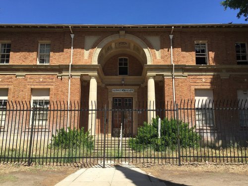
Atascadero’s post office opened in 1914, and 2 of its places are on the National Register
More historic than 27% of U.S. towns · #368 of 847 in California. What drives it
Most of Atascadero was built recently: 5% of its homes predate 1940 and the median home dates from 1983. Its Register listings are the Administration Building, Atascadero Colony and the Atascadero Printery. Below: 3 old photos and papers, maps from 1897 on, and the census since 1950.
The Atascadero post office opened in 1914, the earliest record of the town by name. Wikidata gives 1979. Two smaller post offices, Ascension (1879) and Dove (1889), opened inside today’s city and later closed.
First census: 3,443 in 19502020 census: 29,773112 years
How historic is Atascadero?
C
More historic than 27% of U.S. towns, on its age, its old homes and the National Register.
Founding year: the first Atascadero post office (Blevins & Helbock, CC0). Wikidata: 1979.The full story ↓
History grade
What drives Atascadero’s History grade
On its age, its old homes and the National Register, Atascadero is more historic than 27% of U.S. towns, #368 of 847 in California. Its National Register listings hold the grade up; its age pulls it down.
C
HistoryA character grade: shown, never part of Atascadero’s overall grade.
Few California towns list much on the Register (a typical California town has 0.0 per 10,000 residents, the U.S. 2.4), so Atascadero’s 0.7 sits above most of its state (73% of California towns have fewer) while its 2 listings outnumber those of 60% of U.S. towns.
How sure. Graded on any two of the three inputs instead, the letter would range from D to B−. The pre-1940 share (±1.6 points) is firm at this size. The founding year is the first post office, not a stated founding date; Wikidata gives 1979.
Founding year: the first post office (other dates in Quick answers). Homes: Census ACS 2020–24. National Register: National Park Service, May 2026 list; each listing counted once (boundary changes and added documentation belong to their listing), and a historic district counts its contributing buildings. How TownRatings grades history →
What stands out about Atascadero’s past
Read from the archive, the National Register and the record. The page puts what stands out first.
Atascadero lies in an area associated with both Salinan and Northern Chumash histories. A cultural resources study prepared for the city's general plan describes historical Salinan occupation and the neighboring Obispeño Chumash to the south. It notes disagreement among ethnographers over the boundary between their territories and the possibility that boundaries changed over time. Salinan communities traded with the Yokuts to the east and Chumash communities to the south.
Passages that mention Atascadero, cut from the printed page as they were published.
History of San Luis Obispo County and environs, California, with biographical sketches of the leading men and women of the county and environs who have been identified with the growth and development of the section from the early days to the present1917 · page 166Read the page →
Read the text
Morro now is quite a lively little town. Many summer tourists come each year, and the Atascadero Colony has bought the "Point" and is promising great things at Atascadero Beach. A good-sized tract of land on the bluft' facing the bay and Morro Rock has been purchased, and a temporary building has been put up. Here is to be an all-the-year-round resort, Morro Rock Inn.
Text read by machine from the scan; it may contain errors.
History of San Luis Obispo County and environs, California, with biographical sketches of the leading men and women of the county and environs who have been identified with the growth and development of the section from the early days to the present1917 · page 122Read the page →
Read the text
Atascadero voted $16,000 in its first school bond and a second bond for $3,000. The funds are now being used to erect a fine modern building. The New district l)onded itself for $1,700 to build with. Simmler voted a special tax of $3,000 for a new school. Sunderland voted bonds for $1,600. Lincoln is bonded for $2,700. Shandon sold a $4,000 bond and built a fine new schoolhousc; and after, lo! these many years, San Marcos has as pretty a new schoolhouse as one could wish — but thereby hangs a tale : In August, 1914, Miss Helen Morrison was engaged to teach San Alarcos
Text read by machine from the scan; it may contain errors.
Scans and text from the Internet Archive. Books published in 1930 or earlier, which are in the public domain.
Timeline
Atascadero, 1879 to 1983
Woven from the archive, old maps, post office records, the National Register and the people born here.
Nothing in the archives for these yearsWeddings on Main Street, storms, parades, school pictures, the old store. If it’s in your family album, it belongs here.
The Atascadero post office opened in 1914, the earliest record of the town by name (U.S. post office records). Wikidata gives 1979.
How does Atascadero rank for history?
Atascadero is more historic than 27% of U.S. towns, #368 of 847 in California. The History grade combines the town’s founding era, the share of homes built before 1940 and its National Register listings. It’s a character grade, so it isn’t part of the overall grade. How it works.
What is on the National Register in Atascadero?
Two places: the Administration Building, Atascadero Colony (listed 1977) and the Atascadero Printery (2004).
How old are the homes in Atascadero?
5% of Atascadero’s homes were built before 1940 (Census estimate, ±1.6 points), against a typical 3.4% for a California town; the median home was built in 1983.
Founding dates: Wikidata, Wikipedia, the U.S. post office records of Blevins & Helbock (CC0) and the Census. Homes by year built: Census ACS 2020–24. National Register of Historic Places: National Park Service (list of May 22, 2026). Old photos, postcards and papers: Wikimedia Commons, the Library of Congress and other public archives, credited on each item’s page. Maps: U.S. Geological Survey historical topographic maps (via Esri) and Sanborn fire-insurance maps (Library of Congress). History text and census tables: Wikipedia (CC BY-SA 4.0). Places that used to be: USGS Geographic Names Information System (2021).
From Wikimedia Commons (6), the National Register of Historic Places (2), Wikipedia, Wikidata and Wikipedia for famous people, U.S. Geological Survey historical maps, U.S. Census counts (via Wikipedia), the US Post Offices dataset (Blevins & Helbock), the USGS Geographic Names Information System and old county and town histories (Internet Archive). Archive images are copied here with their credits and licenses, shown on each photo’s page. Refreshed monthly.


 1908
 2013
 2012
 2012