Prescott’s post office opened in 1864, and 65 of its places are on the National Register
More historic than 61% of U.S. towns · #8 of 140 in Arizona. What drives it
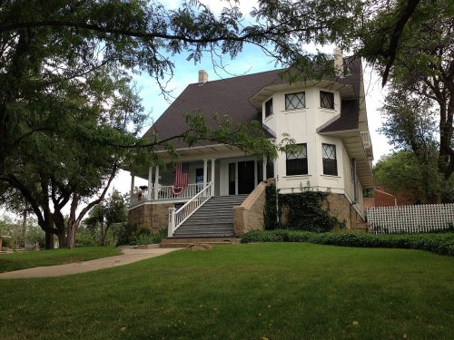
Most of Prescott was built recently: 6% of its homes predate 1940 and the median home dates from 1992. 65 places in town are on the National Register, among them ten historic districts with 688 buildings between them. Below: 6 old photos and papers, maps from 1890 on, and the census since 1870.
The Prescott post office opened in 1864, the earliest record of the town by name. Wikidata gives 1881. Two smaller post offices, Hassayampa (1881) and Whipple (1887), opened inside today’s city and later closed.
First census: 668 in 18702020 census: 45,827162 years
How historic is Prescott?
B
More historic than 61% of U.S. towns, on its age, its old homes and the National Register.
Founding year: the first Prescott post office (Blevins & Helbock, CC0). Wikidata: 1881.The full story ↓
History grade
What drives Prescott’s History grade
On its age, its old homes and the National Register, Prescott is more historic than 61% of U.S. towns, #8 of 140 in Arizona. Its National Register listings hold the grade up; its share of homes from before 1940 pulls it down.
B
HistoryA character grade: shown, never part of Prescott’s overall grade.
Few Arizona towns list much on the Register (a typical Arizona town has 0.1 per 10,000 residents, the U.S. 2.4), so Prescott’s 186 sits above most of its state (97% of Arizona towns have fewer) while its 881 historic buildings outnumber those of 98% of U.S. towns.
How sure. Graded on any two of the three inputs instead, the letter would range from C to B+. The pre-1940 share (±1.3 points) is firm at this size. The founding year is the first post office, not a stated founding date; Wikidata’s 1881 falls in the same era, so the grade doesn’t depend on which one is used.
Founding year: the first post office (other dates in Quick answers). Homes: Census ACS 2020–24. National Register: National Park Service, May 2026 list; each listing counted once (boundary changes and added documentation belong to their listing), and a historic district counts its contributing buildings. How TownRatings grades history →
What stands out about Prescott’s past
Read from the archive, the National Register and the record. The page puts what stands out first.
National Park Service, National Register of Historic Places. Photos from Wikimedia Commons, credited on each place’s page.
Places that used to be
Lost post offices, old corners and burying grounds
Prescott’s post office has been open since 1864. Two other post offices opened and closed inside today’s town.
Prescott
1864–today
Hassayampa
1881–1884
Whipple
1887–1898
18601940today
Hamlets and corners on the map
Beverly Gardens Trailer ParkCasa Loma Mobile Home ParkEntroFort WhippleHeritage Mobile Home ParkIron Springs Manor Mobile Home ParkMiller ValleyP and E JunctionPine Haven Mobile Home ParkPine Lawn Ranch Mobile Home ParkPrescott Gardens Mobile Home ParkPrescott Pines Mobile Home ResortShady Acres Mobile ParkTuttWhippleWhite Cloud Mobile Home Park
9cemeteries and burying grounds inside Prescott
American Lutheran Church ColumbariumArizona Pioneers HomeAztlan Lodge Number 1 MasonicBoblettIndependent Order of Odd FellowsMemorial ParkPrescott NationalRolling HillsSaint Luke's Columbarium
US Post Offices dataset (Blevins & Helbock, CC0). Places and cemeteries from the USGS Geographic Names Information System (2021).
Prescott was originally inhabited by the indigenous Yavapai, who had split off from Patayan groups around 1300 AD. The first recorded European contact with the Yavapai was made by Spaniard Antonio de Espejo in 1583, who was looking for gold. Until the 1860s, there was no permanent European presence. The territory was explored by the Walker Party in 1862 and 1863. Walker and his men discovered gold at Hassayampa Creek, just south of Prescott, in 1863. Further gold was struck at nearby Lynx Creek, Weaver Creek, and Big Bug. With the backing of Ohio railroad magnates, the Arizona Organic Act establishing the Arizona Territory was pushed through in February 1863. The land was now open to settlers. Fort Whipple was established the same year near present day Chino Valley. The fort was also made the territorial capital.
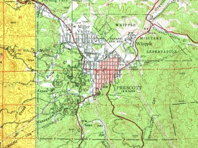
Every edition of the U.S. Geological Survey’s map of Prescott. Tap a year, or press play to watch the town change.
1947Prescott sheet · 1:62,500
U.S. Geological Survey historical topographic maps (public domain), via Esri’s collection of the scans. The red ring marks the center of Prescott.
Every building
Prescott, building by building, 1890–1924
Fire insurance maps drew every building, what it was made of and what it was used for, so insurers could price the risk of fire. Pick a year, then a sheet.
The Prescott post office opened in 1864, the earliest record of the town by name (U.S. post office records). Wikidata gives 1881.
How does Prescott rank for history?
Prescott is more historic than 61% of U.S. towns, #8 of 140 in Arizona. The History grade combines the town’s founding era, the share of homes built before 1940 and its National Register listings. It’s a character grade, so it isn’t part of the overall grade. How it works.
What is on the National Register in Prescott?
65 listings: 50 buildings, among them the Old Governor's Mansion (listed 1971, the first), 13 historic districts with 688 contributing buildings, and 2 structures. 881 historic buildings in all.
How old are the homes in Prescott?
6% of Prescott’s homes were built before 1940 (Census estimate, ±1.3 points), against a typical 0.4% for an Arizona town; the median home was built in 1992.
Founding dates: Wikidata, Wikipedia, the U.S. post office records of Blevins & Helbock (CC0) and the Census. Homes by year built: Census ACS 2020–24. National Register of Historic Places: National Park Service (list of May 22, 2026). Old photos, postcards and papers: Wikimedia Commons, the Library of Congress and other public archives, credited on each item’s page. Maps: U.S. Geological Survey historical topographic maps (via Esri) and Sanborn fire-insurance maps (Library of Congress). History text and census tables: Wikipedia (CC BY-SA 4.0). Places that used to be: USGS Geographic Names Information System (2021).
From Wikimedia Commons (6), the National Register of Historic Places (65), Wikipedia, Wikidata and Wikipedia for famous people, U.S. Geological Survey historical maps, U.S. Census counts (via Wikipedia), the US Post Offices dataset (Blevins & Helbock), the USGS Geographic Names Information System and Sanborn fire insurance maps (Library of Congress). Archive images are copied here with their credits and licenses, shown on each photo’s page. Refreshed monthly.




 1864
 1864
 1875
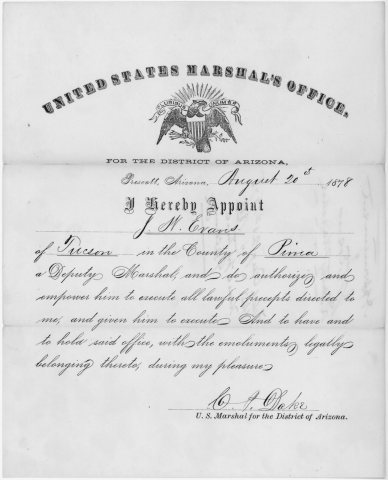 1878


