Guest, Sign inJoin

Post to Oatman

We’ll email a one-tap link to publish your post. No password, and nothing is public until you click it.
Already a member? Sign in
Oatman highway
Arizona›Mohave County

OatmanAZ

The town was settled in 1909 and has 74 residents today.

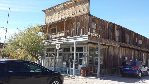
Photo: Pretzelpaws [1] · CC BY-SA 3.0
Photo of Oatman

Oatman, AZ · Photo: Pretzelpaws [1] · CC BY-SA 3.0 · Source ↗

Is Oatman a good place to live?

100% of adults 25 and older hold a bachelor’s degree or more in Oatman, above both the Arizona town median (24%) and the median of U.S. towns (29%). Of the 141 Arizona towns we compare, none has a higher owner-occupancy rate than Oatman. Oatman’s trail density is 6.5 miles per square mile, against 1.1 in Arizona’s towns and 0.4 across U.S. towns. Oatman has 2 places on the National Register of Historic Places, among them Durlin Hotel and Oatman Drug Company Building. Oatman has fewer than 1,000 residents, too few for fair grades; the figures below are still real.

Small town

74 people, and everyone knows the way

In a town this size, neighbors are the best guide. Ask them anything.

Nearby towns
Durlin Hotel
Durlin Hotel · National Register of Historic Places
Oatman’s story

117 years in pictures

The archive holds 6 old photos and papers going back to 1900 and a map from 1967 on.

2 places on the National Register of Historic Places.

  • 1909Oatman is settled
Explore the history →
Getting set up

Moving to Oatman: who provides what

Oatman is unincorporated, so Mohave County and regional agencies provide most services.

PowerUNS Electric17.0¢/kWh · EIA 2025HIFLD · EIA
WaterOatman Water Company1 health-based violation in 5 years · EPAEPA
InternetProviders and speedsData pending · D4
Trash & county servicesMohave CountyMohave County provides services here
SchoolsColorado River Union High School DistrictMohave Valley Elementary District2 districts serve Oatman; which school depends on your address and gradeNCES
Register to voteOnlineIn Arizona you can register online until 29 days before Election Day, in person until 29 days before Election Day, or by mail (postmarked 29 days before).vote.gov
Who runs elections hereMohave County RecorderMohave County; contacts on the Handbook page.FVAP, Sep 2025
ZIP code8643386433 100%Census 2020

EPA SDWIS (Oct 9, 2026) · HIFLD + EIA-861 2025 · Census 2020 ZCTAs · NCES 2024–25 · registration: vote.gov, updated Sep 12, 2025.

The data

Ordered by what stands out in Oatman.

Natural hazards

Top of a high hazard risk in Oatman: inland flooding

Oatman’s FEMA risk score is put at 75 of 100. 52% of the town’s expected losses from natural hazards come from inland flooding, followed by wildfires at 34%.

75risk score of 100
FEMA risk score
75High riskLowerHigher
Inland floodingWildfireHeat waves

FEMA National Risk Index · OpenFEMA

Climate

Mild winters and hot summers: that is Oatman’s year

Its typical July afternoon high is 101°F.

101°summer high

Typical low → high °F

Winter44–60°
Spring56–78°
Summer77–100°
Fall61–81°
Dec 2
typical first frost
Feb 18
typical last frost
+1.6°
vs. the 20th-century average
101°
typical summer high

NOAA U.S. Climate Normals, 1991–2020

Health

How healthy Oatman is

Among adults in Oatman, 19% report frequent physical distress. The town beats the Arizona average on 1 of 32 CDC measures and trails it on 15. Only 6 of the 141 Arizona towns we compare have a higher share of adults who have high blood pressure than Oatman.

OatmanTypical Arizona townTypical U.S. town
High blood pressure (CDC PLACES)48%36%35%
Frequent physical distress (CDC PLACES)19%15%14%
Diabetes (CDC PLACES)17%13%12%
Smoke cigarettes (CDC PLACES)19%13%14%
32 measures vs. Arizona
1 better16 too close to call15 worse
What stands outOatmanAZ
More adults treating high blood pressure81.2%73.9%
More adults with COPD15.6%6.6%
Western Arizona Regional Medical Center
11.3 mi away · emergency room
None
primary care, dental or mental-health shortage

CDC PLACES 2025 · modeled estimates for adults · CMS · HRSA

Outdoors

0% of Oatman is conserved land

1.3 miles of trail.

0%conserved
0%
conserved · 0 of 122 acres
1.3 mi
of trails · 6.5 per sq mi

Trails & parks © OpenStreetMap contributors · Conserved land: USGS PAD-US

Keep exploring

Everything we know about Oatman

14pages on Oatman
After high school

Colleges nearby

None within 15 miles of Oatman; the nearest are

Landmarks

2 places in Oatman on the National Register of Historic Places.

All landmarks →

About Oatman

Census-designated place in Mohave County, Arizona, United States

Oatman is a census-designated place (CDP) in the Black Mountains of Mohave County, Arizona, United States, at an elevation of 2,710 feet (830 m). In 1915, it began as a small mining camp when two prospectors struck US$10 million (equivalent to $181 million in 2025) in gold, though the vicinity had already been settled for several years. Oatman's population grew to more than 3,500 in one year. As of the 2020 United States census, its population was 102.

From Wikipedia, licensed CC BY-SA 4.0 · facts via Wikidata (CC0)

Area
0.2 sq mi
Elevation
2,710 ft
ZIP code
86433

Questions about Oatman

Short answers, built from the data on this page.

Is Oatman, AZ a good place to live?

Oatman has fewer than 1,000 residents, too few for fair grades; the figures below are still real.