Mesa dates to 1878, and 31 of its places are on the National Register
More historic than 42% of U.S. towns · #30 of 140 in Arizona. What drives it
Most of Mesa was built recently: 0.6% of its homes predate 1940 and the median home dates from 1989. 31 places in town are on the National Register, among them nine historic districts with 582 buildings between them. Below: 5 old photos and papers, maps from 1898 on, and the census since 1900.
Founding year: Wikidata. First post office: 1881.The full story ↓
History grade
What drives Mesa’s History grade
On its age, its old homes and the National Register, Mesa is more historic than 42% of U.S. towns, #30 of 140 in Arizona. Its National Register listings hold the grade up; its share of homes from before 1940 pulls it down.
C+
HistoryA character grade: shown, never part of Mesa’s overall grade.
Among the 400 U.S. cities of 100,000 or more, Mesa ranks #261 on History.
Few Arizona towns list much on the Register (a typical Arizona town has 0.1 per 10,000 residents, the U.S. 2.4), so Mesa’s 12.0 sits above most of its state (78% of Arizona towns have fewer) while its 614 historic buildings outnumber those of 98% of U.S. towns.
Newer cities are common at Mesa’s size: in the typical U.S. city of 100,000 or more, 5% of homes predate 1940.
How sure. Graded on any two of the three inputs instead, the letter would range from D to B+. The pre-1940 share (±0.1 points) is firm at this size. Two sources give 1878.
Founding year: Wikidata (other dates in Quick answers). Homes: Census ACS 2020–24. National Register: National Park Service, May 2026 list; each listing counted once (boundary changes and added documentation belong to their listing), and a historic district counts its contributing buildings. How TownRatings grades history →
What stands out about Mesa’s past
Read from the archive, the National Register and the record. The page puts what stands out first.
National Park Service, National Register of Historic Places. Photos from Wikimedia Commons, credited on each place’s page.
Places that used to be
Lost post offices, old corners, places now gone and burying grounds
Mesa’s post office has been open since 1889. Four other post offices opened and closed inside today’s town.
Hayden
1881–1886
Lehi
1884–1904
Zenos
1886–1889
Mesa
1889–today
Meridian
1894–1895
18801950today
Hamlets and corners on the map
Alma GardensAlma Meadows Mobile Home ParkAmbassador Downs Mobile Home ParkAmberwoodApache WellsApache West Mobile VillageBeverly Trailer ParkBonds Trailer ParkBrentwood Mobile ManorBrentwood Southern Mobile Home ParkBrentwood WestBrentwood West Mobile Home ParkBuckhornCasa Serena Mobile Home ParkCastillo Nuevo Mobile Home ParkCibola Mobile Home ParkCitrus GardensCitrus Gardens Mobile Home ParkCitrus Grove Trailer CourtConquistador Mobile Home ParkCoronado Mobile Home ParkCountry Club Village Mobile Home ParkCountry Cousins Mobile MeccaCrescent Run Mobile Home Park
Gone or out of use
Acequis MesacanalAmerican Telephone and Telegraph- Apache Junction HeliportairportApache Junction AirportairportBrimhall Junior High SchoolschoolCanal AlmacanalCanal CasascanalCanal EasterncanalCanal EightcanalCanal ElevencanalCanal Lehi South BranchcanalCanal MesacanalJ S J AirportairportLewis CanalcanalMesa Junior High SchoolschoolRoss AirportairportWilliams Air Force BasemilitaryWilliams Fieldmilitary
3cemeteries and burying grounds inside Mesa
City Of MesaMountain View Funeral Home andQueen of Heaven
US Post Offices dataset (Blevins & Helbock, CC0). Places and cemeteries from the USGS Geographic Names Information System (2021).
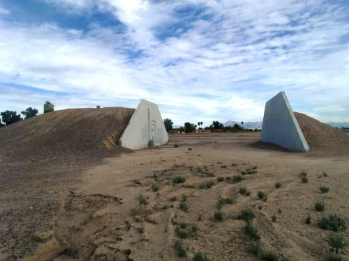
The history of Mesa dates back at least 2,000 years to the arrival of the Hohokam culture. The Hohokam built the original canal system. The canals were the largest and most sophisticated in the prehistoric New World. Some were up to 90 feet (27 m) wide and 10 feet (3.0 m) deep at their head gates, extending for as far as 16 miles (26 km) across the desert. By 1100 CE, water could be delivered to an area over 110,000 acres (450 km2), transforming the Sonoran Desert into an agricultural oasis. By 1450, the Hohokam had constructed hundreds of miles of canals, many of which are still in use.
Nothing in the archives for these yearsWeddings on Main Street, storms, parades, school pictures, the old store. If it’s in your family album, it belongs here.
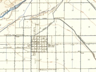
Every edition of the U.S. Geological Survey’s map of Mesa. Tap a year, or press play to watch the town change.
1913Mesa sheet · 1:62,500
U.S. Geological Survey historical topographic maps (public domain), via Esri’s collection of the scans. The red ring marks the center of Mesa.
Every building
Mesa, building by building, 1898–1923
Fire insurance maps drew every building, what it was made of and what it was used for, so insurers could price the risk of fire. Pick a year, then a sheet.
1898Sheet 1 of 1
Edition
Sheets
BrickWoodStone
Sanborn Map Company, via the Library of Congress. Editions published in 1930 or earlier, which are in the public domain.
Then & now
Stand where they stood
No then-and-now pairs yet. Take a photo from the same spot as an old one and they appear here side by side.
Retake this viewBird's eye Chandler's Ranch, 1908
Find the spot, match the angle, and add your photo. It becomes the first then-and-now pair on Mesa’s page.
In 1878, according to Wikidata. Mesa’s post office opened in 1881, and the census of 1900 counted 722 people here.
How does Mesa rank for history?
Mesa is more historic than 42% of U.S. towns, #30 of 140 in Arizona. The History grade combines the town’s founding era, the share of homes built before 1940 and its National Register listings. It’s a character grade, so it isn’t part of the overall grade. How it works.
What is on the National Register in Mesa?
31 listings: 18 buildings, 9 historic districts with 582 contributing buildings, 4 structures, and 1 object. 614 historic buildings in all.
How old are the homes in Mesa?
0.6% of Mesa’s homes were built before 1940 (Census estimate), against a typical 0.4% for an Arizona town; the median home was built in 1989.
Founding dates: Wikidata, Wikipedia, the U.S. post office records of Blevins & Helbock (CC0) and the Census. Homes by year built: Census ACS 2020–24. National Register of Historic Places: National Park Service (list of May 22, 2026). Old photos, postcards and papers: Wikimedia Commons, the Library of Congress and other public archives, credited on each item’s page. Maps: U.S. Geological Survey historical topographic maps (via Esri) and Sanborn fire-insurance maps (Library of Congress). History text and census tables: Wikipedia (CC BY-SA 4.0). Places that used to be: USGS Geographic Names Information System (2021).
From Wikimedia Commons (2), the Library of Congress (3), the National Register of Historic Places (32), Wikipedia, Wikidata and Wikipedia for famous people, U.S. Geological Survey historical maps, U.S. Census counts (via Wikipedia), the US Post Offices dataset (Blevins & Helbock), the USGS Geographic Names Information System and Sanborn fire insurance maps (Library of Congress). Archive images are copied here with their credits and licenses, shown on each photo’s page. Refreshed monthly.







 1908
 1908
 1908
 1908


