Guest, Sign inJoin

Post to Clifton

We’ll email a one-tap link to publish your post. No password, and nothing is public until you click it.
Already a member? Sign in
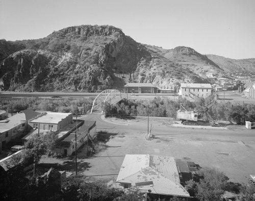
Clifton, AZ train station
Arizona›Greenlee County

CliftonAZ

A town of 3,752, settled in 1875.

1 bordering townMap →
Photo: Ron Reiring · CC BY-SA 2.0
Photo of Clifton

Clifton, AZ · Photo: Ron Reiring · CC BY-SA 2.0 · Source ↗

Why does Clifton grade so well?

Clifton is one of the best-graded places in America: an A+, 2nd of 139 graded towns in Arizona. A typical home costs about $66K, less than a year of the county’s $71K median household income, CDC estimates put its residents' health ahead of 78% of the country, and it has 16 miles of trail and 55% conserved land. The exception is hazard risk: FEMA rates its natural-hazard risk higher than 95% of U.S. communities, with inland flooding at the top. 55% of the land in Clifton is conserved, above both the Arizona town median (14%) and the median of U.S. towns (4.3%). Clifton has 6 places on the National Register of Historic Places, among them Gila River Bridge and Clifton Townsite Historic District. Clifton's civic life (library use, community groups, volunteering) trails 90% of U.S. towns.

What makes Clifton stand out

Where Clifton beats most towns, and one thing worth knowing.

A growing town

Clifton has grown 13% since 2010

3,311 counted in 2010 and 3,933 in 2020; an estimated 3,752 in 2025.

Since 2020 the trend has turned: down 4.6%, after 18.8% growth in the decade before.

3,3112010
3,9332020
3,7522025 est.

U.S. Census 2010 & 2020 counts · Census Bureau estimate, July 1, 2025

How Clifton grades

Each subject compared with towns across the country (schools within Arizona), ordered by how far Clifton is from typical.

How grading works

Its grades run from A+ for cost of living (better than 99% of comparable towns) to D for hazard risk (better than 10%), so the A+ overall blends very different results.

Character Graded, but not part of the overall grade.
Described, not graded Taste, not quality: snow or an older crowd is neither good nor bad.

How TownRatings grades towns →

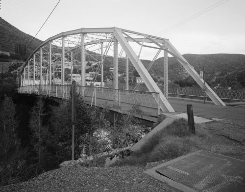
Park Avenue Bridge
Park Avenue Bridge · National Register of Historic Places
Clifton’s story

151 years in pictures

Census counts: 600 in 1890, 3,933 in 2020. The archive holds 18 old photos and papers going back to 1903 and 4 maps from 1902 on.

6 places on the National Register of Historic Places.

  • 1875Clifton is settled
Explore the history →
Getting set up

Moving to Clifton: who provides what

Who provides power, water and the rest in Clifton, and how to reach them.

The full setup list →
PowerDuncan Valley Elec CoopEIAHIFLD · EIA
WaterMorenci Water Elec Co Main4 health-based violations in 5 years · EPAEPA
Internet4 providers99% of addresses get 100/20 MbpsFCC
Trash & dumpNot on file yetWe don’t have Clifton’s trash rules yet
SchoolsMorenci Unified DistrictWhich school depends on your addressNCES
Register to voteOnlineIn Arizona you can register online until 29 days before Election Day, in person until 29 days before Election Day, or by mail (postmarked 29 days before).vote.gov
Who runs elections hereGreenlee County RecorderGreenlee County; contacts on the Handbook page.FVAP, Sep 2025
ZIP codes85540, 8553385540 51% · 85533 49%Census 2020

EPA SDWIS (Oct 9, 2026) · HIFLD + EIA-861 2025 · Census 2020 ZCTAs · NCES 2024–25 · registration: vote.gov, updated Sep 12, 2025.

The data

Ordered by what stands out in Clifton.

Clifton keeps more of its land conserved than most of Arizona and has more 90° days than nearly all U.S. towns, but it is a long drive from an emergency room.

OutdoorsA

Conserved land covers nearly a third of Clifton

Its 5,170 conserved acres are a larger share of the town than in 89% of Arizona towns.

Clifton’s trail density is 1.1 miles per square mile, close to Arizona’s towns (1.1) and above U.S. towns (0.4).

#68for trails in AZ
54.6%
conserved · 5,170 of 9,471 acres
16 mi
of trails · 1.1 per sq mi
Biggest places to walkTrailsAcres
1. Riverview Park0.3 mi3
2. Sumitomo Park0.3 mi3
3. County Ball fields—6

Trails & parks © OpenStreetMap contributors · Conserved land: USGS PAD-US

SchoolsB+

Clifton’s schools rank ahead of 72% of Arizona districts

Its public schools are run by the Morenci Unified District. Two of its 4 schools are below, each with why it’s listed. The largest public high school is Morenci High School, with 361 students.

72%of AZ districts it outscoresB+School Grade
SchoolLevelStudentsLetter
Metcalf Elementary SchoolLargest public elementary schoolGrades PK–4Grades PK–4777A
Morenci High SchoolLargest public high schoolGrades 9–12Grades 9–12361B

NCES · EDFacts · graded within AZ on state tests and graduation

Natural hazardsHazard risk grade D

Inland flooding leads a very high hazard risk in Clifton

Since 1978, 96 flood insurance claims have been paid out in Clifton. Among 140 Arizona towns, just 9 have a higher FEMA risk score than Clifton.

95risk score of 100
FEMA risk score
95Very high riskLowerHigher
Inland floodingWildfireLightning
96
paid flood claims since 1978
1
federal disasters paid out here

FEMA flood insurance claims · FEMA National Risk Index · OpenFEMA

HealthA−

A smaller share of adults have high blood pressure in Clifton than in most of Arizona or the rest of the country

The nearest emergency room, Mt. Graham Regional Medical Center, is 29.7 miles away in a straight line. Its widest gap with Arizona is cancer: 5.2% of its 2,606 adults have had cancer, against 8.8% statewide.

26% of adults have high blood pressure in Clifton. Clifton beats the Arizona average on 9 of 32 CDC measures and trails it on 5. 9.2% of adults have diabetes in Clifton.

78%healthier than U.S. townsA−Health Grade
CliftonArizona townsU.S. towns
Yearly checkup (CDC PLACES)69%75%79%
High blood pressure (CDC PLACES)26%37%35%
Binge drink (CDC PLACES)19%14%16%
No health insurance, 18–64 (CDC PLACES)16%12%8.1%
32 measures vs. Arizona
9 better18 too close to call5 worse
What stands outCliftonAZ
Fewer adults who have had cancer5.2%8.8%
Fewer adults with COPD4.1%6.6%
More uninsured adults16.2%13.2%
Mt. Graham Regional Medical Center
29.7 mi away · emergency room
None
primary care, dental or mental-health shortage
73rd
percentile among AZ towns

CDC PLACES 2025 · modeled estimates for adults · CMS · HRSA

Work & commuteJobs & income grade B+

A smaller share of residents in Clifton live below the poverty line than in the typical Arizona or U.S. town

2.5% of Clifton residents live below the poverty line. Most working residents leave Clifton for work: only 8% work in town. The average trip to work in Clifton is 21 minutes.

8%work in town
CliftonArizona townsU.S. towns
Below the poverty line2.5%12%9.6%
Average trip to work21 minutes24 minutes25 minutes

Where working residents work

In Clifton8%
Morenci56%
Phoenix7%
Tucson3%
Safford2%
2 mi
median commute distance
420
jobs based in Clifton
A commuter town
jobs vs. working residents
C
Walkability grade: more walkable than 32% of U.S. towns

Census LEHD 2023 · ACS

Climate

In Clifton, expect mild winters and hot summers

The Clifton weather station records that about 135 days a year reach 90°, more than in 99% of U.S. towns. July afternoons average 96.6°, hotter than in 98% of U.S. towns; January nights average 32.3°.

Clifton has mild winters and hot summers, with very little rain. Clifton’s July high is 97°F. Snow is almost unheard of.

97°summer high
CliftonArizona townsU.S. towns
July high97°F100°F85°F
January low32°F37°F22°F

Typical low → high °F

Winter33–60°
Spring47–78°
Summer67–96°
Fall50–79°
Nov 23
typical first frost
Feb 26
typical last frost
+1.1°
vs. the 20th-century average
97°
typical summer high

NOAA U.S. Climate Normals, 1991–2020

Keep exploring

Everything we know about Clifton

18pages on Clifton
After high school

Colleges nearby

None within 15 miles of Clifton; the nearest are

Get outside

16 miles of trails in Clifton

54.6% of the town is conserved land, across 3 parks and preserves.

Map of trails and conserved land in CliftonConservedTrails
1
Riverview Park0.3 mi of trails · 3 acres
Directions
2
Sumitomo Park0.3 mi of trails · 3 acres
Directions
3
County Ball fields6 acres
Directions
Trails © OpenStreetMap contributors · USGS PAD-US

Landmarks

6 places in Clifton on the National Register of Historic Places.

All landmarks →

About Clifton

Town in Greenlee County, Arizona

Official town website ↗

Clifton is a town in and the county seat of Greenlee County, Arizona, United States, along the San Francisco River. As of the 2020 census, Clifton had a population of 3,933. It was a place of the Arizona copper mine strike of 1983. Clifton and Morenci are thought to be an economic area by the Arizona Department of Commerce.

From Wikipedia, licensed CC BY-SA 4.0 · facts via Wikidata (CC0)

Area
15 sq mi
Elevation
3,478 ft
ZIP code
85533
Area code
928

Clifton’s neighbors

One town shares a border with Clifton.

Explore the map →
How the neighbors grade
TownAZ rankOverallCostSafetySchoolsHealth
Clifton#2A+A+—B+A−
Morenci——A+—B+A−

Morenci has fewer than 2,500 residents, so it gets subject grades but no overall grade. Clifton and Morenci report no FBI crime data of their own. Compare Clifton with a neighbor →

Questions about Clifton

Short answers, built from the data on this page.

Is Clifton, AZ a good place to live?

Yes, by almost any measure. Clifton grades A+ overall, better than 96% of U.S. towns and #2 of 139 in Arizona. It grades A− for health and B+ for schools. Hazard risk is its weak spot, with a D.

Is Clifton, AZ expensive?

Not for the area. Cost of living, which also weighs rents, property taxes and how many households pay 30% or more of their income for housing, grades A+.