
Ulysses S. Grant National Historic Site
Ulysses S. Grant National Historic Site is a 9.65-acre (3.91 ha) United States National Historic Site located 10 miles (16 km) southwest of downtown St.

A national historic site inside Grantwood Village
July is the busiest month
July averages about 4,754 visitors, 4.4 times January. When to go ↓
Sunset Hills is the nearest base
Sunset Hills is 3 miles southwest, with 7 places to stay. Where to stay ↓
Best month: Oct
October is mild and quieter than average, with a high of 69°. When to go ↓
Established in 1989
Ulysses S. Grant National Historic Site dates from 1989 and is run by National Park Service. About ↓
Written from National Park Service visitor counts, NOAA 1991–2020 normals, Overture places to stay, Census town figures, Wikidata and Wikipedia. Updated when the Park Service posts a new month.
Crowds and weather, month by month
Bars: average monthly visitors, 2022–2025. Line: the typical afternoon high. Green months are mild and quieter than average.
Ulysses S. Grant National Historic Site
Ulysses S. Grant National Historic Site is a 9.65-acre (3.91 ha) United States National Historic Site located 10 miles (16 km) southwest of downtown St. Louis, Missouri, within the municipality of Grantwood Village, Missouri. The site, also known as White Haven, commemorates the life, military career and presidency of Ulysses S. Grant. Five historic structures are preserved at the site, including the childhood home of Ulysses' wife, Julia Dent Grant.
White Haven was an 850-acre plantation worked by enslaved people; Grant worked on his own separate farm on the same property, alongside enslaved people doing the same work.
- Type
- National Historic Site
- Established
- 1989
- Elevation
- 515 ft
- Run by
- National Park Service
- Listed
- National Register of Historic Places (1979)
- Wikipedia readers
- 8K a year
- Official site
- nps.gov/ulsg
Before you go
Where to stay near Ulysses S. Grant National Historic Site
The closest towns with hotels, motels or campgrounds are St. Louis (99) and Maryland Heights (34).
- 1Cahokia
- 2The Dome at America's Center
- 3Busch Stadium
- 4Gateway Arch
- 5Mid America Adventure
- 6Enterprise Center
- 7Monks Mound
- 8Energizer Park
St. Louis
278,144 people
8 mi northeast of Ulysses S. Grant National Historic Site Visitor Center · 8 mi to the park
Maryland Heights
27,559 people
13 mi northwest of Ulysses S. Grant National Historic Site Visitor Center · 13 mi to the park
Fenton
4,060 people
6 mi west of Ulysses S. Grant National Historic Site Visitor Center · 6 mi to the park
Compare 8 towns
| Town | From the visitor center | Drive | Places to stay | People | Typical home | Safety |
|---|---|---|---|---|---|---|
| Grantwood Village | in town | — | — | 925 | $535K | — |
| St. Louis | 8 mi northeast | 10 min | 99 78 hotels · 5 motels · 12 inns & B&Bs · 3 lodges & cabins · 1 campground | 278,144 | $198K | D− |
| Maryland Heights | 13 mi northwest | 20 min | 34 30 hotels · 2 motels · 1 inn or B&B · 1 lodge or cabins | 27,559 | $227K | C+ |
| Fenton | 6 mi west | 10 min | 11 11 hotels | 4,060 | $375K | — |
| Sunset Hills | 3 mi southwest | 5 min | 7 6 hotels · 1 inn or B&B | 9,075 | $524K | B− |
| Bridgeton | 16 mi north | 25 min | 21 18 hotels · 2 motels · 1 inn or B&B | 11,277 | $238K | D− |
| Richmond Heights | 6 mi north | 10 min | 6 6 hotels | 9,093 | $359K | D− |
| Chesterfield | 14 mi northwest | 20 min | 17 16 hotels · 1 campground | 49,309 | $473K | B |
Getting there
Nearest airports with airline service, from the visitor center
Also near Ulysses S. Grant
Other well-known places within 18 miles. Numbered ones are on the map above.
 Big draw117 mi State parkCahokia
 Big draw210 mi Stadium & arenaThe Dome at America's Center
 310 mi Stadium & arenaBusch Stadium
 410 mi National ParkGateway Arch National Park2.2M visitors a year
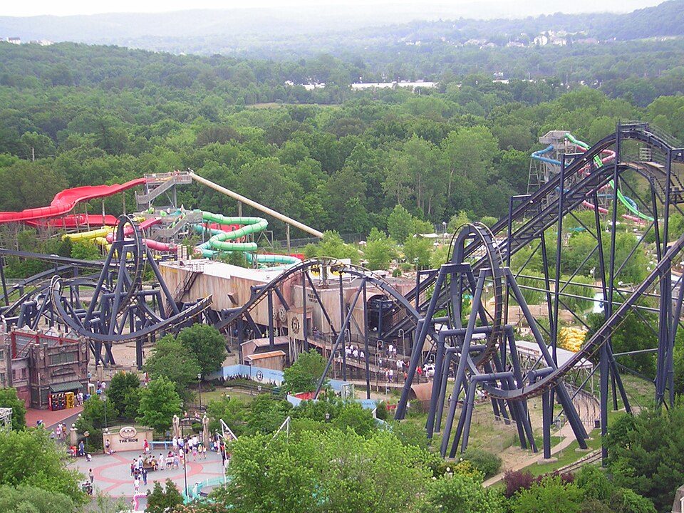 518 mi Theme parkMid America Adventure
 610 mi Stadium & arenaEnterprise Center
 717 mi LandmarkMonks Mound
 89 mi Stadium & arenaEnergizer Park
Photo credits
Cahokia: Thank You (24 Millions ) views, CC BY 2.0 · The Dome at America's Center: Paul Sableman, CC BY 2.0 · Busch Stadium: Lee Ann Ratledge, CC BY 4.0 · Gateway Arch National Park: Daniel Schwen, CC BY-SA 4.0 · Mid America Adventure: Chris Hagerman from New Port Richey, FL, US, CC BY 2.0 · Enterprise Center: Haaron755, CC BY-SA 3.0 · Monks Mound: Skubasteve834, CC BY-SA 3.0 · Energizer Park: Cornfield948, CC BY-SA 3.0


37,467 visitors in 2025
Every full year the Park Service has counted. 2020 (gold) was the pandemic year. Green is the record (2017).
Visiting Ulysses S. Grant
Is Ulysses S. Grant National Historic Site in Grantwood Village?
Yes. It’s inside Grantwood Village, MO. The address is 7400 Grant Road, St. Louis, MO 63123.
When is the best time to visit Ulysses S. Grant National Historic Site?
October, with a high of 69°. July is the busiest month (about 4,754 visitors).
How many people visit Ulysses S. Grant National Historic Site each year?
37,467 in 2025, according to the National Park Service. The record is 59,761, set in 2017.
What is the closest airport to Ulysses S. Grant National Historic Site?
St. Louis Lambert (STL), about 14 miles away.
Where should I stay near Ulysses S. Grant National Historic Site?
St. Louis (8 mi, 99 places to stay), Maryland Heights (13 mi, 34 places to stay) and Fenton (6 mi, 11 places to stay).
Tips from people in Grantwood Village
No tips yet. Ask, or answer, in Grantwood Village’s Town Square.
Sources: National Park Service · ski areas © OpenSkiMap / OpenStreetMap contributors · Wikidata · Wikipedia readership · National Park Service visitor use statistics · NOAA climate normals · U.S. Census.