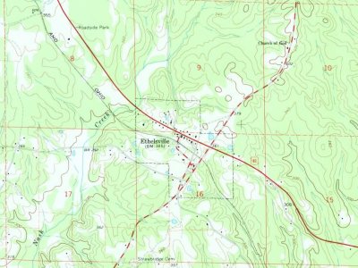
Most of Ethelsville was built recently: 0.0% of its homes predate 1940 and the median home dates from 1964. Below: maps from 1966 on and the census since 1960.
Originally it name named Yorkville. It took its current name from Ethel Burgin Hancock, the daughter of local physician J. T. Hancock. His son Thomas was the town's first postmaster. The town was incorporated in 1952 or 1956, depending on the source, and at the time was still an active railroad stop, with four freight trains and six passenger trains stopping there daily. When the railroad discontinued stops in Ethelsville, the population began to decline. In 1843, local resident John H. Alexander discovered a shield and pair of copper scales while plowing his fields. The shield was engraved with the word "Hispana," which most historians have recognized as evidence that Spanish explorer Hernando de Soto likely passed through Pickens County. Local legend claims that De Soto and his men spent a winter on the hill where Ethelsville Baptist Church stands.
Founding dates: Wikidata, Wikipedia, the U.S. post office records of Blevins & Helbock (CC0) and the Census. Homes by year built: Census ACS 2020–24. National Register of Historic Places: National Park Service (list of May 22, 2026). Old photos, postcards and papers: Wikimedia Commons, the Library of Congress and other public archives, credited on each item’s page. Maps: U.S. Geological Survey historical topographic maps (via Esri) and Sanborn fire-insurance maps (Library of Congress). History text and census tables: Wikipedia (CC BY-SA 4.0). Places that used to be: USGS Geographic Names Information System (2021). How TownRatings grades history →
From Wikipedia, U.S. Geological Survey historical maps, U.S. Census counts (via Wikipedia), the US Post Offices dataset (Blevins & Helbock) and the USGS Geographic Names Information System. Archive images are copied here with their credits and licenses, shown on each photo’s page. Refreshed monthly.