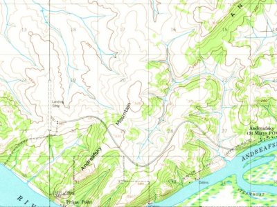
Most of St. Mary's was built recently: 0.0% of its homes predate 1940 and the median home dates from 1993. Below: maps from 1952 on and the census since 1960.
The St. Mary's post office opened in 1955, the earliest record of the town by name. Wikidata gives 1967. Another post office, Andreafsky (1913), opened inside today’s city and later closed.
First census: 225 in 19602020 census: 59971 years
Founding year: the first St. Mary's post office (Blevins & Helbock, CC0). Wikidata: 1967.
What stands out about St. Mary's’ past
Read from the archive, the National Register and the record. The page puts what stands out first.
Two other post offices opened and closed inside today’s town.
Andreafsky
1913–1934
Andreafski
1951–1954
Saint Marys
1955–today
19101970today
Hamlets and corners on the map
Saint MarysTukachak
US Post Offices dataset (Blevins & Helbock, CC0). Places and cemeteries from the USGS Geographic Names Information System (2021).
The story so far
St. Mary's, in brief
Wikipedia doesn’t have a history of St. Mary's yet. The photos, dates and memories neighbors add here are how it gets written.
St. Mary's (Central Yupik: Negeqliq) is a city in Kusilvak Census Area, Alaska, United States. The adjacent village of Andreafsky (historically known as Clear River) joined with St. Mary's in 1980. As of the 2020 census, St. Mary's had a population of 599. Within Saint Mary's there are two federally recognized tribes the Algaaciq Native Village and the Yupiit of Andreafsky.
Its first post office opened in 1955. Between the 2010 and 2020 censuses its population grew from 507 to 599 (+18%).
Intro from Wikipedia. Population: U.S. Census Bureau.
Timeline
St. Mary's, 1913 to 1955
Woven from the archive, old maps, post office records, the National Register and the people born here.
Founding dates: Wikidata, Wikipedia, the U.S. post office records of Blevins & Helbock (CC0) and the Census. Homes by year built: Census ACS 2020–24. National Register of Historic Places: National Park Service (list of May 22, 2026). Old photos, postcards and papers: Wikimedia Commons, the Library of Congress and other public archives, credited on each item’s page. Maps: U.S. Geological Survey historical topographic maps (via Esri) and Sanborn fire-insurance maps (Library of Congress). History text and census tables: Wikipedia (CC BY-SA 4.0). Places that used to be: USGS Geographic Names Information System (2021). How TownRatings grades history →
From Wikimedia Commons (9), U.S. Geological Survey historical maps, U.S. Census counts (via Wikipedia), the US Post Offices dataset (Blevins & Helbock) and the USGS Geographic Names Information System. Archive images are copied here with their credits and licenses, shown on each photo’s page. Refreshed monthly.
 c. 2019
 2015
 2015
 2015
 2015
 2015
 2013
 2012
 2010
