Guest, Sign inJoin

Post to Karluk

We’ll email a one-tap link to publish your post. No password, and nothing is public until you click it.
Already a member? Sign in
–Not graded
History · Karluk

Karluk’s post office opened in 1892, and 1 of its places is on the National Register

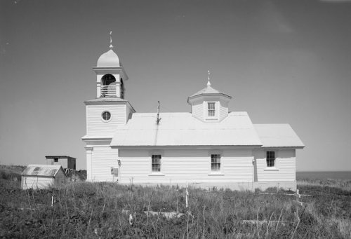
Most of Karluk was built recently: 7% of its homes predate 1940 and the median home dates from 1983. Its Register listing is the Ascension of Our Lord Chapel. Below: 6 old photos and papers, maps from 1952 on, and the census since 1880.

1892first post office
1on the National Register
7%homes built before 1940
6old photos & papers
1famous people
From Karluk’s archive · credits on each photo
Quick answers

How Karluk began

When was Karluk founded?

1892

The Karluk post office opened in 1892, the earliest record of the town by name.

First census: 302 in 18802020 census: 27134 years
Founding year: the first Karluk post office (Blevins & Helbock, CC0).The full story ↓

What stands out about Karluk’s past

Read from the archive, the National Register and the record. The page puts what stands out first.

★ What stands out · People over time

Karluk, census by census

02004006008001,0001,20018801900192019401960198020002020Peak: 1,123

Peaked at 1,123 in 1890; 27 people lived here in 2020.

15 censuses, 1880–2020.

U.S. Census Bureau decennial counts, from the census table on Karluk’s Wikipedia page.

The story

How Karluk came to be

From Wikipedia’s history of Karluk.

Read it all →

In 1787 Evstratii Delarov, manager of the Russian Shelikhov-Golikov Company established an outpost at Karluk.

On March 17, 1945, the village participated in the rescue of seven (7) U.S. Navy aviators who ditched their PB1 Ventura patrol bomber offshore.

In 2021, the Ascension of Our Lord Chapel was relocated from a bluff overlooking the river to prevent its destruction.

Text from Wikipedia, licensed CC BY-SA 4.0.

Timeline

Karluk, 1889 to 1952

Woven from the archive, old maps, post office records, the National Register and the people born here.

  1. 19th century
  2. 1889In the archiveFMIB 34134 Seining Salmon at Karluk, Looking Southwest
  3. 1890CensusPopulation peaks at 1,123
  4. 1892Post officeThe Karluk post office opens
  5. 20th century
  6. 1917Born hereJacob Laktonen is born here
  7. 1952On the mapFirst mapped by the U.S. Geological Survey
By decade

Karluk, decade by decade

One decade in the archive so far: the 1880s. Scroll each row; tap a photo for its story.

On the map

Karluk on the map in 1952

The U.S. Geological Survey’s map of Karluk.

Karluk on the 1952 USGS map1952Karluk C-2 sheet · 1:63,360

U.S. Geological Survey historical topographic maps (public domain), via Esri’s collection of the scans. The red ring marks the center of Karluk.

Then & now

Stand where they stood

No then-and-now pairs yet. Take a photo from the same spot as an old one and they appear here side by side.

FMIB 34134 Seining Salmon at Karluk, Looking Southwest
Retake this viewFMIB 34134 Seining Salmon at Karluk, Looking Southwest, 1889

Find the spot, match the angle, and add your photo. It becomes the first then-and-now pair on Karluk’s page.

Retake this view · +15
On the National Register

1 historic place in Karluk

The country’s official list of buildings and places worth saving.

place listed
1
National Historic Landmarks
0
none yet
historic buildings protected
1
each building in a district counts
first listed
1980
Ascension of Our Lord Chapel

National Park Service, National Register of Historic Places. Photos from Wikimedia Commons, credited on each place’s page.

Help out

Finish Karluk’s story

Most archives stop around 1920. The photos from after that are in family albums, not libraries.

Decades since 1900 with photos
00s10s20s30s40s50s60s70s80s90s
0 of 10 decades. The empty ones are waiting for someone’s album.

Questions about Karluk’s history

What year was Karluk founded?

The Karluk post office opened in 1892, the earliest record of the town by name (U.S. post office records).

What is on the National Register in Karluk?

One place: the Ascension of Our Lord Chapel (listed 1980).

Memory lane

What the archives can’t tell you, neighbors can.

Town Square →
Start a conversation
Sources

Where this page comes from

Founding dates: Wikidata, Wikipedia, the U.S. post office records of Blevins & Helbock (CC0) and the Census. Homes by year built: Census ACS 2020–24. National Register of Historic Places: National Park Service (list of May 22, 2026). Old photos, postcards and papers: Wikimedia Commons, the Library of Congress and other public archives, credited on each item’s page. Maps: U.S. Geological Survey historical topographic maps (via Esri) and Sanborn fire-insurance maps (Library of Congress). History text and census tables: Wikipedia (CC BY-SA 4.0). Places that used to be: USGS Geographic Names Information System (2021). How TownRatings grades history →

From Wikimedia Commons (6), the National Register of Historic Places (1), Wikipedia, Wikidata and Wikipedia for famous people, U.S. Geological Survey historical maps, U.S. Census counts (via Wikipedia) and the US Post Offices dataset (Blevins & Helbock). Archive images are copied here with their credits and licenses, shown on each photo’s page. Refreshed monthly.