Guest, Sign inJoin

Post to Thomas

We’ll email a one-tap link to publish your post. No password, and nothing is public until you click it.
Already a member? Sign in
–Not graded
History · Thomas

Thomas’ post office opened in 1884, and 45% of its homes were built before 1940

4 places in town are on the National Register, among them a historic district with 48 buildings. Below: 13 old photos and papers, maps from 1981 on, and the census since 1890.

1884first post office
4on the National Register
45%homes built before 1940
13old photos & papers
From Thomas’ archive · credits on each photo
Quick answers

How Thomas began, and where its name came from

When was Thomas founded?

1884

The Thomas post office opened in 1884, the earliest record of the town by name.

First census: 269 in 18902020 census: 611142 years

How did Thomas get its name?

Thomas was named for Thomas Beall Davis (1828-1911), brother of Senator Henry Gassaway Davis.

Founding year: the first Thomas post office (Blevins & Helbock, CC0). Name: Wikipedia, licensed CC BY-SA 4.0.The full story ↓

What stands out about Thomas’ past

Read from the archive, the National Register and the record. The page puts what stands out first.

★ What stands out · On the National Register

4 listings protect 51 historic buildings

The country’s official list of buildings and places worth saving.

places listed
4
National Historic Landmarks
0
none yet
historic buildings protected
51
each building in a district counts
first listed
1979
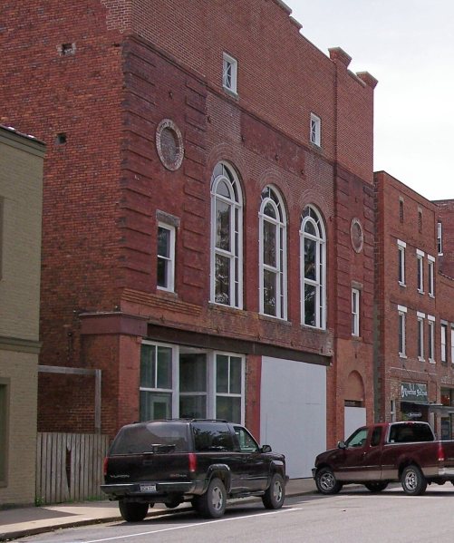
Cottrill Opera House
BuildingsDistricts

Architectural styles listings

Mid-19th Century1
Gothic Revival1
Late Victorian1
Italianate1
Second Renaissance Revival1
Late 19th and 20th Century Revivals1
All 4 listings

National Park Service, National Register of Historic Places. Photos from Wikimedia Commons, credited on each place’s page.

People over time

Thomas, census by census

05001,0001,5002,0002,5001900192019401960198020002020Peak: 2,354

Peaked at 2,354 in 1910; 611 people lived here in 2020.

14 censuses, 1890–2020.

U.S. Census Bureau decennial counts, from the census table on Thomas’ Wikipedia page.

By decade

Thomas, decade by decade

3 decades in the archive, from the 1900s to the 1920s. Scroll each row; tap a photo for its story.

The story

How Thomas came to be

From Wikipedia’s history of Thomas.

Read it all →

Thomas was platted in 1884. Thomas was named for Thomas Beall Davis (1828-1911), brother of Senator Henry Gassaway Davis. The Davis brothers, in 1883, opened a mine near Thomas and had coal ready to ship when their railway arrived a year later. By 1892, Davis Coal and Coke was among the largest and best known coal companies in the world and employed 1,600 people. At the peak of its operations in 1915, there were nine producing mines within a mile of the company's office in Thomas.

Immigrants flocked to the area as miners, railroad laborers, or merchants. The company employed a man named Wladyslaw Dackiewicz as an interpreter. He could speak, read, and write eight languages and his services were much in demand with the influx of immigrants.

Text from Wikipedia, licensed CC BY-SA 4.0.

From the old history books

What they wrote about Thomas in 1906

Passages that mention Thomas, cut from the printed page as they were published.

The little mining town of Thomas continues to be practically the Hub of these operations. It has agencies for the sale of its product established in all the important cities of the continent, presided over by managers, many of whom were formerly located at Thomas, in the capacity of clerks, and in …
Thomas, West Virginia1906 · page 33Read the page →
Read the text

The little mining town of Thomas continues to be practically the Hub of these operations. It has agencies for the sale of its product established in all the important cities of the continent, presided over by managers, many of whom were formerly located at Thomas, in the capacity of clerks, and in other positions. When these managers desire to show their clients the real size and importance of the Company they always bring them to Thomas. In this way the town has been advertised by the Davis Coal & Coke Co., from the Atlantic to the Pacific, and

Text read by machine from the scan; it may contain errors.
T3bomas "3Wle, 3to. 1013, Trattrnal Orbit of TEagUs Thomas Aerie No. 1013, Fraternal Order of Eagles, was instituted in the town of Thomas, March 15, 1905, by State Deputy McNabb of Wheeling. The order has enjoyed a period of continuous prosperity ever since its institution, and has a membership of…
Thomas, West Virginia1906 · page 62Read the page →
Read the text

T3bomas "3Wle, 3to. 1013, Trattrnal Orbit of TEagUs Thomas Aerie No. 1013, Fraternal Order of Eagles, was instituted in the town of Thomas, March 15, 1905, by State Deputy McNabb of Wheeling. The order has enjoyed a period of continuous prosperity ever since its institution, and has a membership of which it feels justly proud. While the membership of the order is relatively large, (144), yet that care and discrimination has been exercised in the choosing of its members that has resulted in the securing of a body of thoroughly

Text read by machine from the scan; it may contain errors.

Scans and text from the Internet Archive. Books published in 1930 or earlier, which are in the public domain.

Timeline

Thomas, 1884 to 1981

Woven from the archive, old maps, post office records, the National Register and the people born here.

  1. 19th century
  2. 1884Post officeThe Thomas post office opens
  3. 20th century
  4. 1904In the archiveTrain-load of ore and miners outside Davis Coal and Coke Industry
  5. 1910CensusPopulation peaks at 2,354
  6. 1912In the archiveView of Thomas, W. Va
  7. 1920In the archiveDavis Coal & Coke Co. Bag teams working one bag event in fourth annual inter-plant first …
  8. 1981On the mapFirst mapped by the U.S. Geological Survey
On the map

Thomas on the map, 1981 to 1995

Every edition of the U.S. Geological Survey’s map of Thomas. Tap a year, or press play to watch the town change.

Thomas on the 1981 USGS mapThomas on the 1995 USGS map1981Davis sheet · 1:24,000

U.S. Geological Survey historical topographic maps (public domain), via Esri’s collection of the scans. The red ring marks the center of Thomas.

Then & now

Stand where they stood

No then-and-now pairs yet. Take a photo from the same spot as an old one and they appear here side by side.

Train-load of ore and miners outside Davis Coal and Coke Industry
Retake this viewTrain-load of ore and miners outside Davis Coal and Coke Industry, 1904

Find the spot, match the angle, and add your photo. It becomes the first then-and-now pair on Thomas’ page.

Retake this view · +15
Famous people

Famous people close to Thomas

Nobody well known was born in Thomas itself, so here are the best known from just nearby.

See all →
Places that used to be

Places now gone and burying grounds

Thomas’s post office has been open since 1884.

Gone or out of use
Saint Thomas SchoolschoolSand Run JunctionlocaleThomas High Schoolschool
2cemeteries and burying grounds inside Thomas
Rose HillThomas

US Post Offices dataset (Blevins & Helbock, CC0). Places and cemeteries from the USGS Geographic Names Information System (2021).

Help out

Finish Thomas’s story

Most archives stop around 1920. The photos from after that are in family albums, not libraries.

Decades since 1900 with photos
00s10s20s30s40s50s60s70s80s90s
3 of 10 decades. The empty ones are waiting for someone’s album.

Questions about Thomas’ history

What year was Thomas founded?

The Thomas post office opened in 1884, the earliest record of the town by name (U.S. post office records).

What is on the National Register in Thomas?

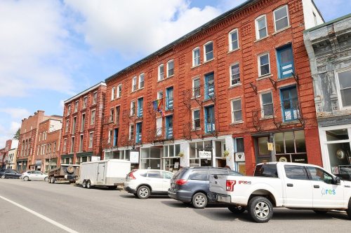
4 listings: 3 buildings, among them the Cottrill Opera House (listed 1979, the first), and 1 historic district, the Thomas Commercial Historic District, with 48 contributing buildings. 51 historic buildings in all.

Memory lane

What the archives can’t tell you, neighbors can.

Town Square →
Start a conversation
Sources

Where this page comes from

Founding dates: Wikidata, Wikipedia, the U.S. post office records of Blevins & Helbock (CC0) and the Census. Homes by year built: Census ACS 2020–24. National Register of Historic Places: National Park Service (list of May 22, 2026). Old photos, postcards and papers: Wikimedia Commons, the Library of Congress and other public archives, credited on each item’s page. Maps: U.S. Geological Survey historical topographic maps (via Esri) and Sanborn fire-insurance maps (Library of Congress). History text and census tables: Wikipedia (CC BY-SA 4.0). Places that used to be: USGS Geographic Names Information System (2021). How TownRatings grades history →

From Wikimedia Commons (18), the Library of Congress (6), the National Register of Historic Places (4), Wikipedia, U.S. Geological Survey historical maps, U.S. Census counts (via Wikipedia), the US Post Offices dataset (Blevins & Helbock), the USGS Geographic Names Information System and old county and town histories (Internet Archive). Archive images are copied here with their credits and licenses, shown on each photo’s page. Refreshed monthly.