8 places in town are on the National Register, among them a historic district with 220 buildings. Below: 12 old photos and papers, maps from 1894 on, and the census since 1850.
Founding year: Wikidata. First post office: 1796.The full story ↓
History grade
What drives Romney’s History grade
On its age, its old homes and the National Register, Romney is more historic than 91% of U.S. towns. All 2 inputs are above most U.S. towns; its National Register listings ranks highest and its share of homes from before 1940 lowest.
A
HistoryA character grade: shown, never part of Romney’s overall grade.
West Virginia towns list more on the Register than most of the country (a typical West Virginia town has 29.6 per 10,000 residents, the U.S. 2.4), so Romney’s 1,212 sits above most of its state (96% of West Virginia towns have fewer) while its 233 historic buildings outnumber those of 94% of U.S. towns.
NoteThe founding year comes from Wikidata alone; no second source gives 1725.
How sure. Graded on two of the three inputs, so a change in either one moves the letter more than it would with three. The pre-1940 share is a Census survey estimate (±6.2 points).
Founding year: Wikidata (other dates in Quick answers). Homes: Census ACS 2020–24. National Register: National Park Service, May 2026 list; each listing counted once (boundary changes and added documentation belong to their listing), and a historic district counts its contributing buildings. How TownRatings grades history →
What stands out about Romney’s past
Read from the archive, the National Register and the record. The page puts what stands out first.
National Park Service, National Register of Historic Places. Photos from Wikimedia Commons, credited on each place’s page.
People over time
Romney, census by census
Lost a third of its people between 1860 and 1880, then grew 4-fold.
18 censuses, 1850–2020.
U.S. Census Bureau decennial counts, from the census table on Romney’s Wikipedia page.
Every building
Romney, building by building, 1894–1923
Fire insurance maps drew every building, what it was made of and what it was used for, so insurers could price the risk of fire. Pick a year, then a sheet.
1894Sheet 1 of 1
Edition
Sheets
BrickWoodStone
Sanborn Map Company, via the Library of Congress. Editions published in 1930 or earlier, which are in the public domain.
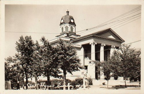
Established by consecutive acts of the Virginia House of Burgesses and approved by the governor on December 23, 1762, Romney and Mecklenburg (later renamed Shepherdstown), in Jefferson County, are the oldest towns in West Virginia. The bill containing the Act for establishing the town of Romney, in the county of Hampshire, and for other purposes therein-mentioned, is listed 20th on a list of approved "publick and private bills" and is immediately followed by An Act for establishing the town of Mecklenburg, in the county of Frederick.
Passages that mention Romney, cut from the printed page as they were published.
History of Hampshire County, West Virginia1897 · page 434Read the page →
Read the text
ney academy the balance of the money raised by lottery; and on December 13, 1846, another legislative act was passed empowering the society uto establish at or near the town of Romney, a seminary of learning for the instruction of youth in the various branches of science and literature; and the society may appropriate to the same such portion of the property which it now has or may hereafter acquire, as it may deem expedient." In accordance with this act a
Text read by machine from the scan; it may contain errors.
History of Hampshire County, West Virginia1897 · page 565Read the page →
Read the text
General Kelley remained in Romney till January 1, 1862, organizingand drillingtroops. He was succeeded at Romney by General Lander. The federals retreated from Romney a few days later at the approach of Stonewall Jackson. When General Kelley entered Romney October 27 he issued the following proclamation: uTo the people of Hampshire county and the upper Potomac: My object in addressingyou is to g-ire you assurance that I have come
Text read by machine from the scan; it may contain errors.
History of Hampshire County, West Virginia, from its earliest settlement to the present1897 · page 604Read the page →
Read the text
Colonel Hill, with the Thirteenth and Tenth Virginia and Third Tennessee Regiments, marched to Romney in June, 1861, and a detachment, consisting of Companies I and K and the Third Tennessee, was sent to New creek to destroy railroad bridges. The bridges were burned, and a skirmish occurred with the Cumberland home guards, in which the guards were defeated, with the loss of two small cannon, which fell into the hands of the confederates.
Text read by machine from the scan; it may contain errors.
History of Hampshire County, West Virginia, from its earliest settlement to the present1897 · page 500Read the page →
Read the text
Distances from Romney .—T'o.q followinglist shows the distance in an "air line" from Romney to the several points named; and it also shows the direction of each from Romney. The directions are expressed in the g-eneral terms of "east," "southeast," "east of southeast," etc., and are not g-iven in deg-rees. They are accurate enough for all practical purposes, althoug-h not strictly correct in all cases. From Romney to Spring-field, north
Text read by machine from the scan; it may contain errors.
Scans and text from the Internet Archive. Books published in 1930 or earlier, which are in the public domain.
Timeline
Romney, 1725 to 1970
Woven from the archive, old maps, post office records, the National Register and the people born here.
Nothing in the archives for these yearsWeddings on Main Street, storms, parades, school pictures, the old store. If it’s in your family album, it belongs here.
In 1725, according to Wikidata. Romney’s post office opened in 1796, and the census of 1850 counted 456 people here.
How does Romney rank for history?
Romney is more historic than 91% of U.S. towns. The History grade combines the town’s founding era, the share of homes built before 1940 and its National Register listings. It’s a character grade, so it isn’t part of the overall grade. How it works.
What is on the National Register in Romney?
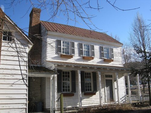
8 listings: 7 buildings, among them the Wilson-Wodrow-Mytinger House (listed 1977, the first), and 1 historic district, the Romney Historic District, with 220 contributing buildings. 233 historic buildings in all.
How old are the homes in Romney?
16% of Romney’s homes were built before 1940 (Census estimate, ±6.2 points), against a typical 13% for a West Virginia town; the median home was built in 1973.
Founding dates: Wikidata, Wikipedia, the U.S. post office records of Blevins & Helbock (CC0) and the Census. Homes by year built: Census ACS 2020–24. National Register of Historic Places: National Park Service (list of May 22, 2026). Old photos, postcards and papers: Wikimedia Commons, the Library of Congress and other public archives, credited on each item’s page. Maps: U.S. Geological Survey historical topographic maps (via Esri) and Sanborn fire-insurance maps (Library of Congress). History text and census tables: Wikipedia (CC BY-SA 4.0). Places that used to be: USGS Geographic Names Information System (2021).
From Wikimedia Commons (4), the Library of Congress (8), the National Register of Historic Places (8), Wikipedia, Wikidata and Wikipedia for famous people, U.S. Geological Survey historical maps, U.S. Census counts (via Wikipedia), the US Post Offices dataset (Blevins & Helbock), the USGS Geographic Names Information System, Sanborn fire insurance maps (Library of Congress) and old county and town histories (Internet Archive). Archive images are copied here with their credits and licenses, shown on each photo’s page. Refreshed monthly.






 1861
 1862
 1902
 1906
 1939
 1939
 1939
 1939
 1939


