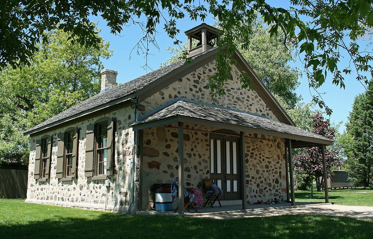
Fredonia in pictures
Census counts: 312 in 1930, 2,279 in 2020. The archive holds 3 old photos and papers going back to 1976 and 2 maps from 1954 on.
2 places on the National Register of Historic Places.
Explore the history →Each edition grades its towns against each other only.
17% of residents are under 18 in Fredonia, against 21% in Wisconsin’s towns and 22% across U.S. towns. Fredonia has 2 places on the National Register of Historic Places, among them Stony Hill School and Kendall Cabinet Shop. We don’t grade Fredonia yet; the figures below are still real.
Where Fredonia’s working residents go each day. Line width shows the share.
Census LEHD 2023
Census counts: 312 in 1930, 2,279 in 2020. The archive holds 3 old photos and papers going back to 1976 and 2 maps from 1954 on.
2 places on the National Register of Historic Places.
Explore the history →Who provides power, water and the rest in Fredonia, and how to reach them.
EPA SDWIS (Oct 9, 2026) · HIFLD + EIA-861 2025 · Census 2020 ZCTAs · NCES 2024–25 · registration: vote.gov, updated Nov 18, 2024.
Ordered by what stands out in Fredonia.
Expected storm and flood damage is lower than in 80% of U.S. communities. Since 2004, 3 flood insurance claims have been paid out in Fredonia.
FEMA flood insurance claims · FEMA National Risk Index · OpenFEMA
Most working residents leave Fredonia for work: only 3% work in town. Since 2013, Fredonia has added 93 jobs, to 335 in 2023. 5.3% of residents live below the poverty line in Fredonia, where Wisconsin’s towns sit at 6.4% and U.S. towns at 9.6%.
| Fredonia | Wisconsin towns | U.S. towns | |
|---|---|---|---|
| Working residents who work in town | 2.8% | 8.3% | 8% |
| Below the poverty line | 5.3% | 6.4% | 9.6% |
| Average trip to work | 23 minutes | 22 minutes | 25 minutes |
Census LEHD 2023 · ACS
Fredonia has cold, snowy winters and pleasant summers. Fredonia’s July high is 81°F.
NOAA U.S. Climate Normals, 1991–2020
Fredonia beats the Wisconsin average on 4 of 32 CDC measures and trails it on 0. 20% of Fredonia adults binge drink.
| Fredonia | Wisconsin towns | U.S. towns | |
|---|---|---|---|
| Binge drink (CDC PLACES) | 20% | 20% | 16% |
| Feel lonely (CDC PLACES) | 28% | 30% | 33% |
| Sleep under 7 hours (CDC PLACES) | 31% | 32% | 36% |
| High blood pressure (CDC PLACES) | 31% | 33% | 35% |
| What stands out | Fredonia | WI |
|---|---|---|
| Fewer adults facing food insecurity | 9.7% | 12.1% |
| Fewer adults facing housing insecurity | 8.1% | 9.7% |
CDC PLACES 2025 · modeled estimates for adults · CMS · HRSA
0.0 miles of trail in 6 parks and preserves. The biggest park or preserve is Huiras Lake State Natural Area, at 122 acres.
| Biggest places to walk | Trails | Acres |
|---|---|---|
| 1. North Branch Milwaukee River Wildlife and Farm Heritage Area | — | 152 |
| 2. Huiras Lake State Natural Area | — | 122 |
| 3. Hawthorne Hills County Park | — | 63 |
Trails & parks © OpenStreetMap contributors · Conserved land: USGS PAD-US
None within 15 miles of Fredonia; the nearest are
About 4 of every 100 Fredonia residents are enrolled in college, against 6 across Wisconsin.
2 places in Fredonia on the National Register of Historic Places.
Village in Ozaukee County, Wisconsin
Fredonia is a village in Ozaukee County, Wisconsin, United States. Located on the Milwaukee River, the village is in the Milwaukee metropolitan area. The population was 2,279 at the 2020 census. The community was the site of a Potawatomi village until at least the 1840s. The first white settlers in the area were Yankees, Germans and Luxembourgers who arrived in the 1840s, but the community was rural until the 1870s when the Chicago, Milwaukee & St. Paul Railway built a station in the area and businesses began to cluster it, laying the foundation for the village. Fredonia grew, incorporating in 1922. The village is located east of the unincorporated census-designated place of Waubeka, the lo…
From Wikipedia, licensed CC BY-SA 4.0 · facts via Wikidata (CC0)
5 towns share a border with Fredonia.
| Town | WI rank | Overall | Cost | Safety | Schools | Health |
|---|---|---|---|---|---|---|
| Fredonia | — | — | — | — | — | — |
| Fredonia | — | — | B− | — | A− | B+ |
| Farmington | #142 | A− | C+ | — | A | B+ |
| Saukville | — | — | C+ | — | A− | B+ |
| Sherman | — | — | C+ | — | B− | B |
| Belgium | — | — | C | — | A− | A− |
Fredonia, Saukville, Sherman and Belgium have fewer than 2,500 residents, so they get subject grades but no overall grade. Fredonia, Farmington, Saukville, Sherman and Belgium report no FBI crime data of their own. Fredonia isn’t graded (fewer than 1,000 residents, or not enough data). Compare Fredonia with a neighbor →
Short answers, built from the data on this page.
We don’t grade Fredonia yet; the figures below are still real.