Delavan’s post office opened in 1837, and 24% of its homes were built before 1940
More historic than 92% of U.S. towns · #34 of 362 in Wisconsin. What drives it
7 places in town are on the National Register, among them two historic districts with 37 buildings between them. Below: 2 old photos and papers, maps from 1885 on, and the census since 1860.
The Delavan post office opened in 1837, the earliest record of the town by name. Another post office, Turtle Creek (1839), opened inside today’s city and later closed.
First census: 1,549 in 18602020 census: 8,505189 years
How historic is Delavan?
A
More historic than 92% of U.S. towns, on its age, its old homes and the National Register.
Founding year: the first Delavan post office (Blevins & Helbock, CC0).The full story ↓
History grade
What drives Delavan’s History grade
On its age, its old homes and the National Register, Delavan is more historic than 92% of U.S. towns, #34 of 362 in Wisconsin. All 3 inputs are above most U.S. towns; its National Register listings ranks highest and its age lowest.
A
HistoryA character grade: shown, never part of Delavan’s overall grade.
Wisconsin towns list more on the Register than most of the country (a typical Wisconsin town has 3.0 per 10,000 residents, the U.S. 2.4), so Delavan’s 47.2 sits above most of its state (88% of Wisconsin towns have fewer) while its 41 historic buildings outnumber those of 84% of U.S. towns.
How sure. Graded on any two of the three inputs instead, the letter would range from A− to A. The pre-1940 share is a Census survey estimate (±4.8 points). The founding year is the first post office, not a stated founding date.
Founding year: the first post office (other dates in Quick answers). Homes: Census ACS 2020–24. National Register: National Park Service, May 2026 list; each listing counted once (boundary changes and added documentation belong to their listing), and a historic district counts its contributing buildings. How TownRatings grades history →
What stands out about Delavan’s past
Read from the archive, the National Register and the record. The page puts what stands out first.
Every edition of the U.S. Geological Survey’s map of Delavan. Tap a year, or press play to watch the town change.
1893Delavan sheet · 1:62,500
U.S. Geological Survey historical topographic maps (public domain), via Esri’s collection of the scans. The red ring marks the center of Delavan.
Every building
Delavan, building by building, 1885–1910
Fire insurance maps drew every building, what it was made of and what it was used for, so insurers could price the risk of fire. Pick a year, then a sheet.
Delavan sits in the middle of what was once an inland sea. During the last ice age, the final glaciation, named the Michigan tongue, covered this region. The Michigan tongue descended along the area of Lake Michigan. The "Delavan lobe" of this glacier broke off, pushing southwest into the area of Walworth County.
Passages that mention Delavan, cut from the printed page as they were published.
History of Walworth County, Wisconsin, containing an account of its settlement, growth, development and resources...its war record, biographical sketches, portraits of prominent men and early settlers1882 · page 60Read the page →
Read the text
The second charitable institution incorporated by the State was the " Wisconsin Institute for the Education of the Deaf and Dumb." It was originally a private school for deaf mutes, near, and subsequently in, the village of Delavan, Walworth county. By an act of the legislature approved April 19, 1852, it was made the object and duty of the corporation to establish, continue and maintain this school for the education of the deaf and dumb, "at or near the village of Delavan, to qualify, as near as might be, that unfortunate class of persons for the enjoyment of the blessings of a free government, obtaining the means of subsistence, and the discharge of those duties, social and political, devolving upon American citizens." It has since been sup-
Text read by machine from the scan; it may contain errors.
History of Walworth County, Wisconsin, containing an account of its settlement, growth, development and resources...its war record, biographical sketches, portraits of prominent men and early settlers1882 · page 472Read the page →
Read the text
embraced but a single section of the original town, viz.. Section 36, in Town 3, Range 16. By that act, the present town of Elkhorn was established. The boundaries were described as follows: "All that part of the county of Walworth comprised in Section 36, in the town of Elkhorn; Section 1, in the town of Delavan: Section 6, in the town of Geneva, and Section 31, in the town of La Fayette, is hereby set off and organized into a separate town by the name of Elkhorn," and except Section 36, the remaining part of Elkhorn was organized as a new town under the name of Sugar Creek. The town of Elkhorn, as organized by the act of Februaiy 2, 1846, is a square of two miles, embraces the geographical center of the county, and is the
Text read by machine from the scan; it may contain errors.
History of Walworth county, Wisconsin ..1912 · page 437Read the page →
Read the text
Township i north, range 16 east, was a part of the town of Delavan until February 28. 1839, when it was set off and named for the county. It then for four years included Sharon. Next southward are the towns of Alden and Chemung, in Illinois. The ground is generally high, much like that of Sharon. At the observatory it is one thousand fifty feet above sealevel, and nearly as high for a considerable area about that institution. At the railway station, village of Walworth, the height is one thousand four feet. The lowest point is a short' and narrow area at the end of Geneva lake,
Text read by machine from the scan; it may contain errors.
Scans and text from the Internet Archive. Books published in 1930 or earlier, which are in the public domain.
Timeline
Delavan, 1837 to 1980
Woven from the archive, old maps, post office records, the National Register and the people born here.
Nothing in the archives for these yearsWeddings on Main Street, storms, parades, school pictures, the old store. If it’s in your family album, it belongs here.
Nothing in the archives for these yearsWeddings on Main Street, storms, parades, school pictures, the old store. If it’s in your family album, it belongs here.
The Delavan post office opened in 1837, the earliest record of the town by name (U.S. post office records).
How does Delavan rank for history?
Delavan is more historic than 92% of U.S. towns, #34 of 362 in Wisconsin. The History grade combines the town’s founding era, the share of homes built before 1940 and its National Register listings. It’s a character grade, so it isn’t part of the overall grade. How it works.
What is on the National Register in Delavan?
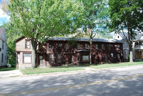
7 listings: 4 buildings, among them the Stowell, Israel, Temperance House (listed 1978, the first), 2 historic districts, the Delavan Downtown Commercial Historic District and the Delavan Water Tower Park Historic District, with 37 contributing buildings, and 1 structure. 41 historic buildings in all.
How old are the homes in Delavan?
24% of Delavan’s homes were built before 1940 (Census estimate, ±4.8 points), against a typical 12% for a Wisconsin town; the median home was built in 1968.
Founding dates: Wikidata, Wikipedia, the U.S. post office records of Blevins & Helbock (CC0) and the Census. Homes by year built: Census ACS 2020–24. National Register of Historic Places: National Park Service (list of May 22, 2026). Old photos, postcards and papers: Wikimedia Commons, the Library of Congress and other public archives, credited on each item’s page. Maps: U.S. Geological Survey historical topographic maps (via Esri) and Sanborn fire-insurance maps (Library of Congress). History text and census tables: Wikipedia (CC BY-SA 4.0). Places that used to be: USGS Geographic Names Information System (2021).
From Wikimedia Commons (12), the Library of Congress (1), Wikidata (5), the National Register of Historic Places (7), Wikipedia, Wikidata and Wikipedia for famous people, U.S. Geological Survey historical maps, U.S. Census counts (via Wikipedia), the US Post Offices dataset (Blevins & Helbock), the USGS Geographic Names Information System, Sanborn fire insurance maps (Library of Congress) and old county and town histories (Internet Archive). Archive images are copied here with their credits and licenses, shown on each photo’s page. Refreshed monthly.




 2013
 2012
 2012
 2012
 2012
 2012
 2012
 2009
 2009
 2008
 2005
