
Blooming Grove Fire Department, 2012
Blooming Grove’s story
Blooming Grove in pictures
The archive holds 9 old photos and papers going back to 2004 and 6 maps from 1890 on.
Explore the history →Each edition grades its towns against each other only.

Blooming Grove’s best subject grades are an A+ for walkability, an A for health, and an A− for incomes. On walkability, just 5 of Wisconsin’s 879 towns do better. Blooming Grove’s trail density is 2.3 miles per square mile, where Wisconsin’s towns sit at 0.4 and U.S. towns at 0.4. No town in Wisconsin scores higher than Blooming Grove on the outdoors. Capital Springs State Recreation Area, at 702 acres with 1.3 miles of trail, is the biggest park or preserve. Blooming Grove has fewer than 2,500 residents, so it gets subject grades but no overall grade.
Where Blooming Grove beats most towns.
In a town this size, neighbors are the best guide. Ask them anything.
Each subject compared with towns across the country (schools within Wisconsin), ordered by how far Blooming Grove is from typical.
How TownRatings grades towns →
The archive holds 9 old photos and papers going back to 2004 and 6 maps from 1890 on.
Explore the history →Museums, parks, gardens and other places to visit around Blooming Grove. Close and well known come first.
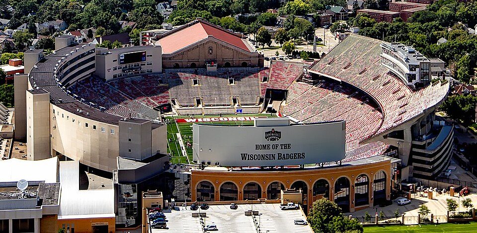 6 mi Stadium & arenaCamp Randall Stadium
 5 mi Stadium & arenaKohl Center
 35 mi Park & preserveIce Age Trail
 5 mi Zoo & aquariumHenry Vilas Zoo
 23 mi State parkAztalan State Park
 5 mi GardenOlbrich Botanical Gardens
Camp Randall Stadium: Carol M. Highsmith, Public domain · Kohl Center: Pbrown111 at English Wikipedia, Public domain · Ice Age Trail: MDuchek, CC BY-SA 3.0 · Henry Vilas Zoo: Corey Coyle, CC BY 3.0 · Aztalan State Park: Joshua Mayer - Flickr user wackybadger, CC BY-SA 2.0 · Olbrich Botanical Gardens: Chief-O at English Wikipedia, Public domain
Who provides power, water and the rest in Blooming Grove, and how to reach them.
EPA SDWIS (Oct 9, 2026) · HIFLD + EIA-861 2025 · Census 2020 ZCTAs · NCES 2024–25 · registration: vote.gov, updated Nov 18, 2024.
Ordered by what stands out in Blooming Grove.
Blooming Grove beats the Wisconsin average on 19 of 32 CDC measures and trails it on 2. 26% of adults have high blood pressure in Blooming Grove, below both Wisconsin’s towns (33%) and U.S. towns (35%). 29% of adults sleep under 7 hours in Blooming Grove.
| Blooming Grove | Wisconsin towns | U.S. towns | |
|---|---|---|---|
| High blood pressure (CDC PLACES) | 26% | 33% | 35% |
| Sleep under 7 hours (CDC PLACES) | 29% | 32% | 36% |
| Frequent physical distress (CDC PLACES) | 10% | 13% | 14% |
| Yearly checkup (CDC PLACES) | 74% | 78% | 79% |
| What stands out | Blooming Grove | WI |
|---|---|---|
| Fewer adults with COPD | 4.3% | 6.5% |
| Fewer older adults who have lost all their teeth | 6.9% | 9.9% |
| Fewer adults getting a yearly checkup | 74% | 77.6% |
CDC PLACES 2025 · modeled estimates for adults · CMS · HRSA
One of its 2 schools is below, with why it’s listed.
| School | Level | Students | Letter |
|---|---|---|---|
| Blooming Grove Montessori PrivateLargest school before high school | 61 | – |
NCES · EDFacts · graded within WI on state tests and graduation
Expected storm and flood damage is lower than in 97% of U.S. communities. Since 2013, 3 flood insurance claims have been paid out in Blooming Grove.
FEMA flood insurance claims · FEMA National Risk Index · OpenFEMA
| Biggest places to walk | Trails | Acres |
|---|---|---|
| 1. Madison Metropolitan Sewerage District Wildlife Observation Area | 4.5 mi | 198 |
| 2. Capital Springs State Park | 2.2 mi | 247 |
| 3. Capital Springs State Recreation Area | 1.3 mi | 702 |
Trails & parks © OpenStreetMap contributors · Conserved land: USGS PAD-US
Blooming Grove has cold, snowy winters and pleasant summers. July afternoons reach 83°, January nights drop to 11° and about 52 inches of snow falls in a winter.
NOAA U.S. Climate Normals, 1991–2020
Of the 363 Wisconsin towns we compare, none has a lower share of working residents who work in town than Blooming Grove. Jobs based in Blooming Grove grew to 704 in 2023, 78 more than in 2013. The average trip to work in Blooming Grove is 21 minutes.
| Blooming Grove | Wisconsin towns | U.S. towns | |
|---|---|---|---|
| Working residents who work in town | 0.4% | 8.3% | 8% |
| Work from home | 15% | 12% | 11% |
| Average trip to work | 21 minutes | 22 minutes | 25 minutes |
| Median household income | $90,000 | $87,000 | $80,000 |
Census LEHD 2023 · ACS
4 within 15 miles of the center of Blooming Grove
About 6 of every 100 Blooming Grove residents are enrolled in college, about the same as Wisconsin.
1,815 counted in 2010 and 1,622 in 2020; an estimated 1,488 in 2025.
U.S. Census 2010 & 2020 counts · Census Bureau estimate, July 1, 2025
Town in Wisconsin, United States
Blooming Grove is a town in Dane County, Wisconsin, United States. The population was 1,622 at the 2020 census. The unincorporated community of Hope is located partially within Blooming Grove. Although once much larger, currently the town of Blooming Grove consists of a few scattered neighborhoods and individual properties broken into discontinuous sections by the cities of Madison and Monona. Blooming Grove is set to be dissolved and annexed into the city of Madison by 2027.
From Wikipedia, licensed CC BY-SA 4.0 · facts via Wikidata (CC0)
Short answers, built from the data on this page.
The typical home is worth about $307,000. Cost of living, which also weighs rents, property taxes and how many households pay 30% or more of their income for housing, grades B.


