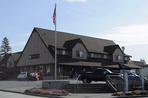
Steilacoom’s post office opened in 1852, and 4 of its places are on the National Register
More historic than 56% of U.S. towns · #51 of 285 in Washington. What drives it
Most of Steilacoom was built recently: 6% of its homes predate 1940 and the median home dates from 1978. 4 places in town are on the National Register, among them a historic district with 38 buildings. Below: 4 old photos and papers, maps from 1948 on, and the census since 1880.
Founding year: the first Steilacoom post office (Blevins & Helbock, CC0).The full story ↓
History grade
What drives Steilacoom’s History grade
On its age, its old homes and the National Register, Steilacoom is more historic than 56% of U.S. towns, #51 of 285 in Washington. Its National Register listings hold the grade up; its share of homes from before 1940 pulls it down.
B
HistoryA character grade: shown, never part of Steilacoom’s overall grade.
Few Washington towns list much on the Register (a typical Washington town has 0.1 per 10,000 residents, the U.S. 2.4), so Steilacoom’s 64.3 sits above most of its state (95% of Washington towns have fewer) while its 43 historic buildings outnumber those of 84% of U.S. towns.
How sure. Graded on any two of the three inputs instead, the letter would range from C to B+. The pre-1940 share (±2.4 points) is firm at this size. The founding year is the first post office, not a stated founding date.
Founding year: the first post office (other dates in Quick answers). Homes: Census ACS 2020–24. National Register: National Park Service, May 2026 list; each listing counted once (boundary changes and added documentation belong to their listing), and a historic district counts its contributing buildings. How TownRatings grades history →
What stands out about Steilacoom’s past
Read from the archive, the National Register and the record. The page puts what stands out first.
The Steilacoom people, a Coast Salish tribe, lived in what became the city of Steilacoom. Their main village was called Scht’ləqʷəm, later anglicized as Steilacoom. William Bright says the name comes from the Southern Coast Salish subgroup /č'tílqʷəbš/, anglicized as "Steilacoom".
Passages that mention Steilacoom, cut from the printed page as they were published.
History of Pierce County Washington1927 · page 71Read the page →
Read the text
When Abraham W. Stewart was one year old, the family moved to Cedar Rapids, Iowa, and there he was reared and educated. In the fall of 1851 he made the long overland trip with ox teams to Washington territory, locating first at what is now Olympia, where he lived several years. About 1855 he came to Steilacoom, where he built a gristmill for Burd Brothers. He was a wagon maker and spinning wheel maker by trade. He took up a homestead in what is now the central part of Tacoma, proved up on it, and cleared off part of it, building a house, in which he lived until 1873. He then moved to Whatcom county, this state, where he took up a
Text read by machine from the scan; it may contain errors.
History of Pierce County Washington1927 · page 132Read the page →
Read the text
In recalling conditions existing in the early days here, Mrs. Alward states that while living on Anderson’s island they were compelled to go to Steilacoom for their mail, there being no post office then on the island, and two or three times a week she and her son rowed a boat to the mainland for the mail. In the early years of the Western Washington Fair she took a deep interest in it and in order to swell the exhibits she would take vegetables, fruit, grain, grasses and stock for exhibit. She has always been a strong booster for the fair, being an honorary vice president for many years, and she has contributed of her efforts to its success. As farmer and
Text read by machine from the scan; it may contain errors.
Scans and text from the Internet Archive. Books published in 1930 or earlier, which are in the public domain.
Timeline
Steilacoom, 1850 to 1971
Woven from the archive, old maps, post office records, the National Register and the people born here.
Nothing in the archives for these yearsWeddings on Main Street, storms, parades, school pictures, the old store. If it’s in your family album, it belongs here.
The Steilacoom post office opened in 1852, the earliest record of the town by name (U.S. post office records).
How does Steilacoom rank for history?
Steilacoom is more historic than 56% of U.S. towns, #51 of 285 in Washington. The History grade combines the town’s founding era, the share of homes built before 1940 and its National Register listings. It’s a character grade, so it isn’t part of the overall grade. How it works.
What is on the National Register in Steilacoom?
4 listings: 3 buildings, among them the Nathaniel Orr House and Orchard (listed 1972, the first), and 1 historic district, the Steilacoom Historic District, with 38 contributing buildings. 43 historic buildings in all.
How old are the homes in Steilacoom?
6% of Steilacoom’s homes were built before 1940 (Census estimate, ±2.4 points), against a typical 4.3% for a Washington town; the median home was built in 1978.
Founding dates: Wikidata, Wikipedia, the U.S. post office records of Blevins & Helbock (CC0) and the Census. Homes by year built: Census ACS 2020–24. National Register of Historic Places: National Park Service (list of May 22, 2026). Old photos, postcards and papers: Wikimedia Commons, the Library of Congress and other public archives, credited on each item’s page. Maps: U.S. Geological Survey historical topographic maps (via Esri) and Sanborn fire-insurance maps (Library of Congress). History text and census tables: Wikipedia (CC BY-SA 4.0). Places that used to be: USGS Geographic Names Information System (2021).
From Wikimedia Commons (4), Wikidata (2), the National Register of Historic Places (4), Wikipedia, U.S. Geological Survey historical maps, U.S. Census counts (via Wikipedia), the US Post Offices dataset (Blevins & Helbock), the USGS Geographic Names Information System and old county and town histories (Internet Archive). Archive images are copied here with their credits and licenses, shown on each photo’s page. Refreshed monthly.






 1898