Puyallup’s post office opened in 1874, and 4 of its places are on the National Register
More historic than 47% of U.S. towns · #70 of 285 in Washington. What drives it
Most of Puyallup was built recently: 7% of its homes predate 1940 and the median home dates from 1987. Below: 5 old photos and papers, maps from 1888 on, and the census since 1870.
The Puyallup post office opened in 1874, the earliest record of the town by name. Another post office, Franklin (1860), opened inside today’s city and later closed.
First census: 312 in 18702020 census: 42,973152 years
How historic is Puyallup?
B−
More historic than 47% of U.S. towns, on its age, its old homes and the National Register.
Founding year: the first Puyallup post office (Blevins & Helbock, CC0).The full story ↓
History grade
What drives Puyallup’s History grade
On its age, its old homes and the National Register, Puyallup is more historic than 47% of U.S. towns, #70 of 285 in Washington. Its National Register listings hold the grade up; its age pulls it down.
B−
HistoryA character grade: shown, never part of Puyallup’s overall grade.
Few Washington towns list much on the Register (a typical Washington town has 0.1 per 10,000 residents, the U.S. 2.4), so Puyallup’s 1.6 sits near the middle of its state (63% of Washington towns have fewer) while its 7 historic buildings outnumber those of 73% of U.S. towns.
How sure. Graded on any two of the three inputs instead, the letter would range from C to B. The pre-1940 share (±1.5 points) is firm at this size. The founding year is the first post office, not a stated founding date.
Founding year: the first post office (other dates in Quick answers). Homes: Census ACS 2020–24. National Register: National Park Service, May 2026 list; each listing counted once (boundary changes and added documentation belong to their listing), and a historic district counts its contributing buildings. How TownRatings grades history →
What stands out about Puyallup’s past
Read from the archive, the National Register and the record. The page puts what stands out first.
Fire insurance maps drew every building, what it was made of and what it was used for, so insurers could price the risk of fire. Pick a year, then a sheet.
The Puyallup Valley was originally inhabited by the Puyallup people, known in their language as the spuyaləpabš, meaning "generous and welcoming behavior to all people (friends and strangers) who enter our lands." The first white settlers in the region were part of the first wagon train to cross the Cascade Range at Naches Pass in 1853.
Passages that mention Puyallup, cut from the printed page as they were published.
History of Pierce County Washington1927 · page 238Read the page →
Read the text
physician in charge of all the Puget Sound Indians, holding that position for ten years during which time he also looked after his ranch. He also bought six hundred and forty acres of land southeast of Tacoma, where he lived a part of the time, makin of it a stock ranch. In 1876 the Doctor moved to the town of Puyallup ohare ke purchased a tract of land, which he cleared and planted to hops. eter he bought a thousand acres of land in Stuck valley, along the county line, and became one of chs largest land owners in Pierce county, clearing and developing approximately one thousand acres of his land. He continued to live in the Puyallup valley until AR Hon
Text read by machine from the scan; it may contain errors.
History of Pierce County Washington1927 · page 155Read the page →
Read the text
Mutual Telephone Company, of Washington county, that state, which he operated until leaving the state, when he sold it. On coming to the Pacific coast he first located in Oregon, where he remained about one and a half years, and in 1910 came to Puyallup and bought the controlling interest in the Puyallup Valley Home Telephone Company, of which he is now president. This company, which was organized in 1908, covers the territory contributory to Puyallup and embraces twelve hundred subscribers. It has long distance connections through the Bell telephone system, and about fifteen people are on the payroll.
Text read by machine from the scan; it may contain errors.
Scans and text from the Internet Archive. Books published in 1930 or earlier, which are in the public domain.
Timeline
Puyallup, 1860 to 1941
Woven from the archive, old maps, post office records, the National Register and the people born here.
Nothing in the archives for these yearsWeddings on Main Street, storms, parades, school pictures, the old store. If it’s in your family album, it belongs here.
The Puyallup post office opened in 1874, the earliest record of the town by name (U.S. post office records).
How does Puyallup rank for history?
Puyallup is more historic than 47% of U.S. towns, #70 of 285 in Washington. The History grade combines the town’s founding era, the share of homes built before 1940 and its National Register listings. It’s a character grade, so it isn’t part of the overall grade. How it works.
What is on the National Register in Puyallup?
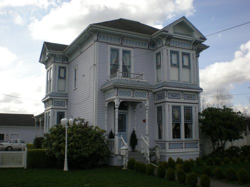
4 listings: 4 buildings, among them the Ezra Meeker Mansion (listed 1971, the first). 7 historic buildings in all.
How old are the homes in Puyallup?
7% of Puyallup’s homes were built before 1940 (Census estimate, ±1.5 points), against a typical 4.3% for a Washington town; the median home was built in 1987.
Founding dates: Wikidata, Wikipedia, the U.S. post office records of Blevins & Helbock (CC0) and the Census. Homes by year built: Census ACS 2020–24. National Register of Historic Places: National Park Service (list of May 22, 2026). Old photos, postcards and papers: Wikimedia Commons, the Library of Congress and other public archives, credited on each item’s page. Maps: U.S. Geological Survey historical topographic maps (via Esri) and Sanborn fire-insurance maps (Library of Congress). History text and census tables: Wikipedia (CC BY-SA 4.0). Places that used to be: USGS Geographic Names Information System (2021).
From Wikimedia Commons (2), the Library of Congress (3), Wikidata (1), the National Register of Historic Places (4), Wikipedia, U.S. Geological Survey historical maps, U.S. Census counts (via Wikipedia), the US Post Offices dataset (Blevins & Helbock), the USGS Geographic Names Information System, Sanborn fire insurance maps (Library of Congress) and old county and town histories (Internet Archive). Archive images are copied here with their credits and licenses, shown on each photo’s page. Refreshed monthly.




 1907
 1907


