Founding year: the first Orting post office (Blevins & Helbock, CC0).The full story ↓
History grade
What drives Orting’s History grade
On its age, its old homes and the National Register, Orting is more historic than 48% of U.S. towns, #66 of 285 in Washington. Its National Register listings hold the grade up; its age pulls it down.
B−
HistoryA character grade: shown, never part of Orting’s overall grade.
Few Washington towns list much on the Register (a typical Washington town has 0.1 per 10,000 residents, the U.S. 2.4), so Orting’s 1.1 sits near the middle of its state (61% of Washington towns have fewer) while its 1 listings outnumber those of 51% of U.S. towns.
How sure. Graded on any two of the three inputs instead, the letter would range from C+ to B. The pre-1940 share is a Census survey estimate (±4.5 points). The founding year is the first post office, not a stated founding date.
Founding year: the first post office (other dates in Quick answers). Homes: Census ACS 2020–24. National Register: National Park Service, May 2026 list; each listing counted once (boundary changes and added documentation belong to their listing), and a historic district counts its contributing buildings. How TownRatings grades history →
What stands out about Orting’s past
Read from the archive, the National Register and the record. The page puts what stands out first.
Fire insurance maps drew every building, what it was made of and what it was used for, so insurers could price the risk of fire. Pick a year, then a sheet.
1890Sheet 1 of 1
Edition
Sheets
BrickWoodStone
Sanborn Map Company, via the Library of Congress. Editions published in 1930 or earlier, which are in the public domain.
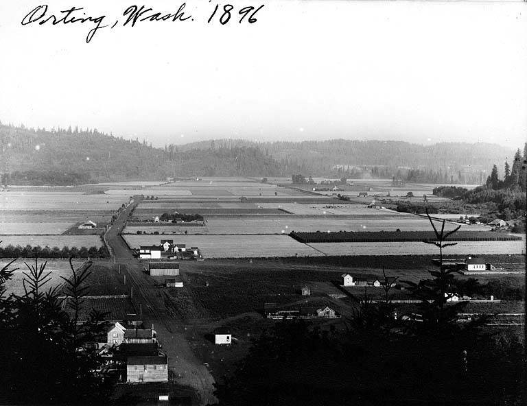
The first recorded claims for land in Orting were made in 1854 by William Henry Whitesell, Thomas Headley, Daniel Lane, and Daniel Varner. Streets in the modern city are named after the four men, and a monument in Orting City Park commemorates them. The area was named Gunson's Prairie by early settlers and later known as Carbon. The townsite was renamed Orting by a Northern Pacific Railway superintendent in 1877 during construction of the company's railroad to Wilkeson. The name is claimed to be an indigenous word meaning "prairie". Orting was officially incorporated as a city on April 22, 1889.
Passages that mention Orting, cut from the printed page as they were published.
History of Pierce County Washington1927 · page 318Read the page →
Read the text
Mr. Taylor tells of the first schoolhouse at Orting, which was really only a log hut, with dirt floor and open fireplace. In 1874 he succeeded in getting a better schoolhouse built of lumber, and this old relic of the past, which has been somewhat remodeled, now stands near his home. His early years here were literally days of struggle, but today the memory of that time is pleasant, for they were days of accomplishment and cooperation, when neighbors were neighbors in spirit. Through all the years of his residence here he has been an interested spectator of the wonderful development and progress of this section of the country and today believes that
Text read by machine from the scan; it may contain errors.
History of Pierce County Washington1927 · page 425Read the page →
Read the text
settled first in Pennsylvania, where he lived about a year, being employed in the coal mines. In January, 1889, he came to Pierce county, Washington, and found employment on John Boatman’s hop ranch near Puyallup. Later that year, he and his brother John leased the Ernest Boatman hop and dairy ranch at Orting, which they operated together until January 6, 1891, when they were joined by their brothers, Robert and Oscar, who came from Sweden to Orting, and they all combined in the
Text read by machine from the scan; it may contain errors.
Scans and text from the Internet Archive. Books published in 1930 or earlier, which are in the public domain.
Timeline
Orting, 1878 to 1942
Woven from the archive, old maps, post office records, the National Register and the people born here.
Nothing in the archives for these yearsWeddings on Main Street, storms, parades, school pictures, the old store. If it’s in your family album, it belongs here.
The Orting post office opened in 1878, the earliest record of the town by name (U.S. post office records).
How does Orting rank for history?
Orting is more historic than 48% of U.S. towns, #66 of 285 in Washington. The History grade combines the town’s founding era, the share of homes built before 1940 and its National Register listings. It’s a character grade, so it isn’t part of the overall grade. How it works.
What is on the National Register in Orting?
One place: the Woolrey-Koehler Hop Kiln (listed 1983).
How old are the homes in Orting?
12% of Orting’s homes were built before 1940 (Census estimate, ±4.5 points), against a typical 4.3% for a Washington town; the median home was built in 2003.
Founding dates: Wikidata, Wikipedia, the U.S. post office records of Blevins & Helbock (CC0) and the Census. Homes by year built: Census ACS 2020–24. National Register of Historic Places: National Park Service (list of May 22, 2026). Old photos, postcards and papers: Wikimedia Commons, the Library of Congress and other public archives, credited on each item’s page. Maps: U.S. Geological Survey historical topographic maps (via Esri) and Sanborn fire-insurance maps (Library of Congress). History text and census tables: Wikipedia (CC BY-SA 4.0). Places that used to be: USGS Geographic Names Information System (2021).
From Wikimedia Commons (12), the National Register of Historic Places (1), Wikipedia, U.S. Geological Survey historical maps, U.S. Census counts (via Wikipedia), the US Post Offices dataset (Blevins & Helbock), the USGS Geographic Names Information System, Sanborn fire insurance maps (Library of Congress) and old county and town histories (Internet Archive). Archive images are copied here with their credits and licenses, shown on each photo’s page. Refreshed monthly.




 1904
 1904
 2008
 2008
 2008
 2007
 2007
 2007
 2006
 2004


