Guest, Sign inJoin

Post to Roanoke

We’ll email a one-tap link to publish your post. No password, and nothing is public until you click it.
Already a member? Sign in
A−History
History · Roanoke

Roanoke dates to 1852, and 25% of its homes were built before 1940

More historic than 81% of U.S. towns · #38 of 253 in Virginia. What drives it

60 places in town are on the National Register, among them ten historic districts with 3,880 buildings between them. Below: 10 old photos and papers, maps from 1886 on, and the census since 1880.

1852founded
60on the National Register
25%homes built before 1940
10old photos & papers
55famous people
From Roanoke’s archive · credits on each photo
Quick answers

How Roanoke began

When was Roanoke founded?

1852

Roanoke dates its founding to 1852 (Wikidata). The census first counted it in 1880.

First census: 669 in 18802020 census: 100,011174 years

How historic is Roanoke?

A−

More historic than 81% of U.S. towns, on its age, its old homes and the National Register.

What drives the grade ↓
Founding year: Wikidata. First post office: 1881.The full story ↓
History grade

What drives Roanoke’s History grade

On its age, its old homes and the National Register, Roanoke is more historic than 81% of U.S. towns, #38 of 253 in Virginia. Its National Register listings hold the grade up; its age pulls it down.

A−
HistoryA character grade: shown, never part of Roanoke’s overall grade.
All U.S. towns we grade (21,289)Ahead of 81%
NewerOlder
Virginia towns of 2,500+ (253)Ahead of 85%

Virginia towns list more on the Register than most of the country (a typical Virginia town has 3.6 per 10,000 residents, the U.S. 2.4), so Roanoke’s 401 sits above most of its state (87% of Virginia towns have fewer) while its 3,947 historic buildings outnumber those of 100% of U.S. towns.

NoteThe founding year comes from Wikidata alone; no second source gives 1852.
How sure. Graded on any two of the three inputs instead, the letter would range from B to A. The pre-1940 share (±1.6 points) is firm at this size.

Founding year: Wikidata (other dates in Quick answers). Homes: Census ACS 2020–24. National Register: National Park Service, May 2026 list; each listing counted once (boundary changes and added documentation belong to their listing), and a historic district counts its contributing buildings. How TownRatings grades history →

What stands out about Roanoke’s past

Read from the archive, the National Register and the record. The page puts what stands out first.

★ What stands out · On the National Register

60 listings protect 3,947 historic buildings

The country’s official list of buildings and places worth saving. Boundary changes and added documentation are counted with their listing.

places listed
60
National Historic Landmarks
0
none yet
historic buildings protected
3,947
each building in a district counts
first listed
1973
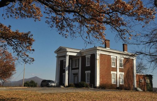
Lone Oaks
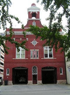
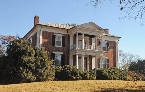
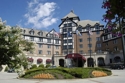
Lone OaksFire Station No. 1St. Andrew's Roman Catholic ChurchBuena VistaMontereyBelle AireCrystal Spring Steam Pumping StationMountain ViewFirst National BankHarrison SchoolRoanoke Warehouse Historic DistrictRoanoke City Market Historic DistrictColonial National BankBoxley BuildingCampbell Avenue ComplexRoanoke City Firehouse No. 6, built 1911Henry, Patrick, Hotel, built 1925St. John's Episcopal ChurchHuntingdonMount Moriah Baptist Church And CemeteryHotel Roanoke, built 1882The Coffee PotGainsboro Branch of the Roanoke City Public LibraryNorfolk and Western Railway Company Historic DistrictRoanoke Star, built 1949Black Horse Tavern-Bellvue Hotel and OfficeRoanoke Downtown Historic DistrictGrandin Road Commercial Historic DistrictVirginian Railway Passenger StationBurrell Memorial HospitalBoxley-Sprinkle HouseHenry Street Historic DistrictGainsboro Historic DistrictVirginia Can Company-S.H. Heironimus WarehouseRoanoke ApartmentsSalem Avenue-Roanoke Automotive Commercial Historic DistrictLawson, H.L., & Son WarehouseApartment Building on Windsor Avenue and Brunswick St.Belmont Methodist-Episcopal ChurchCity of Roanoke Fire Station No. 5, built 1911Wasena Historic DistrictRoanoke Veterans Administration Hospital Historic DistrictCarlin's Amoco StationNorfolk & Western Railway Freight StationTayloe Rogers HouseMelrose-Rugby Historic DistrictRiverland Historic DistrictRoanoke River and Railroad Historic DistrictRoanoke City Health CenterVilla HeightsBelmont Historic DistrictAmerican Viscose Plant Historic DistrictSalvation Army Citadel, built 1941Southwest Historic DistrictEnglish GardensColony House Motor Lodge, built 1959Norfolk & Western Class J No. 611 LocomotiveNorwich Historic DistrictNorfolk & Western Class A No. 1218 LocomotiveLucy Addison High School
BuildingsDistrictsStructures

Architectural styles listings

Colonial Revival9
Tudor Revival7
Art Deco6
Classical Revival5
Greek Revival5
Commercial Style5
All 60 listings
First National BankBuilding · listed 1982Harrison SchoolBuilding · listed 1982Roanoke Warehouse Historic DistrictDistrict · listed 1983Roanoke City Market Historic DistrictDistrict · listed 1983Colonial National BankBuilding · listed 1983Boxley BuildingBuilding · listed 1984Campbell Avenue ComplexBuilding · listed 1991Roanoke City Firehouse No. 6Building · listed 1991Henry, Patrick, HotelBuilding · listed 1991St. John's Episcopal ChurchBuilding · listed 1991HuntingdonBuilding · listed 1991Mount Moriah Baptist Church And CemeteryBuilding · listed 1994Hotel RoanokeBuilding · listed 1996The Coffee PotBuilding · listed 1996Gainsboro Branch of the Roanoke City Public LibraryBuilding · listed 1996Norfolk and Western Railway Company Historic DistrictDistrict · listed 1999Roanoke StarStructure · listed 1999Black Horse Tavern-Bellvue Hotel and OfficeBuilding · listed 2002Roanoke Downtown Historic DistrictDistrict · listed 2002Grandin Road Commercial Historic DistrictDistrict · listed 2002Virginian Railway Passenger StationBuilding · listed 2003Burrell Memorial HospitalBuilding · listed 2003Boxley-Sprinkle HouseBuilding · listed 2004Henry Street Historic DistrictDistrict · listed 2004Gainsboro Historic DistrictDistrict · listed 2005Virginia Can Company-S.H. Heironimus WarehouseBuilding · listed 2006Roanoke ApartmentsBuilding · listed 2006Salem Avenue-Roanoke Automotive Commercial Historic DistrictDistrict · listed 2007Lawson, H.L., & Son WarehouseBuilding · listed 2008Apartment Building on Windsor Avenue and Brunswick St.Building · listed 2010Belmont Methodist-Episcopal ChurchBuilding · listed 2011City of Roanoke Fire Station No. 5Building · listed 2011Wasena Historic DistrictDistrict · listed 2012Roanoke Veterans Administration Hospital Historic DistrictDistrict · listed 2012Carlin's Amoco StationBuilding · listed 2012Norfolk & Western Railway Freight StationBuilding · listed 2012Tayloe Rogers HouseBuilding · listed 2012Melrose-Rugby Historic DistrictDistrict · listed 2013Riverland Historic DistrictDistrict · listed 2013Roanoke River and Railroad Historic DistrictDistrict · listed 2013Roanoke City Health CenterBuilding · listed 2016Villa HeightsBuilding · listed 2018Belmont Historic DistrictDistrict · listed 2019American Viscose Plant Historic DistrictDistrict · listed 2019Salvation Army CitadelBuilding · listed 2020Southwest Historic DistrictDistrict · listed 2020English GardensDistrict · listed 2022Colony House Motor LodgeBuilding · listed 2023Norfolk & Western Class J No. 611 LocomotiveStructure · listed 2024Norwich Historic DistrictDistrict · listed 2024Norfolk & Western Class A No. 1218 LocomotiveStructure · listed 2025Lucy Addison High SchoolBuilding · listed 2025

National Park Service, National Register of Historic Places. Photos from Wikimedia Commons, credited on each place’s page.

Places that used to be

Lost post offices, old corners, places now gone and burying grounds

Roanoke’s post office has been open since 1881. Two other post offices opened and closed inside today’s town.

Roanoke
1881–today
Farland
1892–1912
Washington Heights
1892–1894
18801950today
Hamlets and corners on the map
Airlee CourtAirview CourtArrington CourtArrow WoodAvendaleBarrangerBeechwood GardensBelle AireBellview TerraceBlue HillsBlue Ridge ParkBluefield HeightsBluestoneBowling GreenBowman LawnBratton LawnBrentwoodBuena VistaCarol HeightsCarter HeightsCedar BluffCenter HillChapel ForestChatham Hill
Gone or out of use
Lansdowne MissionchurchParkview Schoolschool
16cemeteries and burying grounds inside Roanoke
Beth IsraelBlue Ridge Memorial GardensCampbells Burial ParkCedar Lawn Burial ParkEmanuelEvergreenFairviewJonathan ToshLouryMemorial Bridge ParkOld LickPeters CreekRoanoke CitySaint AndrewsSpringwoodWilliams Memorial Park

US Post Offices dataset (Blevins & Helbock, CC0). Places and cemeteries from the USGS Geographic Names Information System (2021).

The story

How Roanoke came to be

From Wikipedia’s history of Roanoke.

Read it all →

The current site of Roanoke lies near the intersection of the Great Wagon Road and the Carolina Road, two branches of a network of early colonial roads that developed from Native American trails in the Appalachian region. While the name Roanoke is said to have originated from a Native American word for shell beads used as currency, that word was first used 300 miles (480 km) away, where the Roanoke River empties into the Atlantic Ocean near Roanoke Island. When Europeans arrived, the Roanoke Valley itself was home to members of the Tutelo tribe, a Siouan-speaking people who were gradually pushed out of the area by advancing European settlers.

Text from Wikipedia, licensed CC BY-SA 4.0.

From the old history books

What they wrote about Roanoke in 1888

Passages that mention Roanoke, cut from the printed page as they were published.

Lawson wrote in 1714, one hundred and twenty-seven years after the colonists were last seen on Roanoke Island. Sixty nine years after the settlement on that island, and sixty years betore the event related by Lawson, Roanoke was visited by an Englishman, Francis Yeardly, who, in a letter to John Fa…
Sir Walter Raleigh's lost colony. An historical sketch of the attempts of Sir Walter Raleigh to establish a colony in Virginia, with the traditions of an Indian tribe in North Carolina. Indicating the fate of the colony of Englishmen left on Roanoke Islan1888 · page 12Read the page →
Read the text

Lawson wrote in 1714, one hundred and twenty-seven years after the colonists were last seen on Roanoke Island. Sixty nine years after the settlement on that island, and sixty years betore the event related by Lawson, Roanoke was visited by an Englishman, Francis Yeardly, who, in a letter to John Farrar, Esquire, dated May 8th 1654, relates a visit made to Roanoke Island by himself and others, ''where or thereabouts they found the great commander of these parts with his Indians ahunting, wbo received

Text read by machine from the scan; it may contain errors.
We must remtmber that the region embracing Croatan Island and the adjacent mainland was unexplored for a long period after the attempt at settlement on Roanoke Island. The history of those times shows tiiat in 1609 the northeast corner of North Carolina was settled by a colony from Virginia.
Sir Walter Raleigh's lost colony. An historical sketch of the attempts of Sir Walter Raleigh to establish a colony in Virginia, with the traditions of an Indian tribe in North Carolina. Indicating the fate of the colony of Englishmen left on Roanoke Islan1888 · page 25Read the page →
Read the text

We must remtmber that the region embracing Croatan Island and the adjacent mainland was unexplored for a long period after the attempt at settlement on Roanoke Island. The history of those times shows tiiat in 1609 the northeast corner of North Carolina was settled by a colony from Virginia.

Text read by machine from the scan; it may contain errors.

Scans and text from the Internet Archive. Books published in 1930 or earlier, which are in the public domain.

Timeline

Roanoke, 1852 to 1949

Woven from the archive, old maps, post office records, the National Register and the people born here.

  1. 19th century
  2. 1852
    FoundingRoanoke is established
  3. 1880In the archiveSketch map of the vicinity of Roanoke, Virginia
  4. 1881Post officeThe Roanoke post office opens
  5. 1882BuiltHotel Roanoke is built
  6. 1890In the archiveRoanoke Virginia 1890
  7. 1892Post officeThe Farland post office opens
  8. 1892Post officeThe Washington Heights post office opens
  9. 1894Post officeThe Washington Heights post office closes
  10. 20th century
  11. 1900In the archiveLog farmhouse
  12. 1911BuiltRoanoke City Firehouse No. 6 is built
  13. 1912Born hereJohn Payne is born here
  14. 1912Post officeThe Farland post office closes
  15. 1913Born hereLynn Bari is born here
  16. 1920Born hereHenrietta Lacks is born here
  17. 1925BuiltHenry, Patrick, Hotel is built
  18. 1929On the mapFirst mapped by the U.S. Geological Survey
  19. 1946Born hereJohn C. Mather is born here
  20. 1949BuiltRoanoke Star is built
By decade

Roanoke, decade by decade

3 decades in the archive, from the 1880s to the 1900s. Scroll each row; tap a photo for its story.

On the map

Roanoke on the map, 1929 to 1984

Every edition of the U.S. Geological Survey’s map of Roanoke. Tap a year, or press play to watch the town change.

Roanoke on the 1929 USGS mapRoanoke on the 1933 USGS mapRoanoke on the 1962 USGS mapRoanoke on the 1977 USGS mapRoanoke on the 1984 USGS map1929Roanoke sheet · 1:62,500

U.S. Geological Survey historical topographic maps (public domain), via Esri’s collection of the scans. The red ring marks the center of Roanoke.

Every building

Roanoke, building by building, 1886–1930

Fire insurance maps drew every building, what it was made of and what it was used for, so insurers could price the risk of fire. Pick a year, then a sheet.

Roanoke fire insurance map, 1886, sheet 41886Sheet 4 of 5
Edition
BrickWoodStone

Sanborn Map Company, via the Library of Congress. Editions published in 1930 or earlier, which are in the public domain.

Then & now

Stand where they stood

No then-and-now pairs yet. Take a photo from the same spot as an old one and they appear here side by side.

Flag of
Retake this viewFlag of, 1884

Find the spot, match the angle, and add your photo. It becomes the first then-and-now pair on Roanoke’s page.

Retake this view · +15
People over time

Roanoke, census by census

020,00040,00060,00080,000100,00018801900192019401960198020002020Peak: 100,220

Between 669 and 100,220 people in every census since 1880.

15 censuses, 1880–2020.

U.S. Census Bureau decennial counts, from the census table on Roanoke’s Wikipedia page.

Famous people

55 famous people were born in Roanoke

Writers, athletes, leaders and more, ranked by how widely they’re known.

See all →
Help out

Finish Roanoke’s story

Most archives stop around 1920. The photos from after that are in family albums, not libraries.

Decades since 1900 with photos
00s10s20s30s40s50s60s70s80s90s
1 of 10 decades. The empty ones are waiting for someone’s album.
Stories next door

History across the town line

Each neighbor’s History grade, on the same three inputs.

Questions about Roanoke’s history

What year was Roanoke founded?

In 1852, according to Wikidata. Roanoke’s post office opened in 1881, and the census of 1880 counted 669 people here.

How does Roanoke rank for history?

Roanoke is more historic than 81% of U.S. towns, #38 of 253 in Virginia. The History grade combines the town’s founding era, the share of homes built before 1940 and its National Register listings. It’s a character grade, so it isn’t part of the overall grade. How it works.

What is on the National Register in Roanoke?

60 listings: 38 buildings, among them the Lone Oaks (listed 1973, the first), 18 historic districts with 3,880 contributing buildings, and 4 structures. 3,947 historic buildings in all.

How old are the homes in Roanoke?

25% of Roanoke’s homes were built before 1940 (Census estimate, ±1.6 points), against a typical 1.9% for a Virginia town; the median home was built in 1958.

Memory lane

What the archives can’t tell you, neighbors can.

Town Square →
Start a conversation
Sources

Where this page comes from

Founding dates: Wikidata, Wikipedia, the U.S. post office records of Blevins & Helbock (CC0) and the Census. Homes by year built: Census ACS 2020–24. National Register of Historic Places: National Park Service (list of May 22, 2026). Old photos, postcards and papers: Wikimedia Commons, the Library of Congress and other public archives, credited on each item’s page. Maps: U.S. Geological Survey historical topographic maps (via Esri) and Sanborn fire-insurance maps (Library of Congress). History text and census tables: Wikipedia (CC BY-SA 4.0). Places that used to be: USGS Geographic Names Information System (2021).

From Wikimedia Commons (8), the Library of Congress (2), Wikidata (1), the National Register of Historic Places (60), Wikipedia, Wikidata and Wikipedia for famous people, U.S. Geological Survey historical maps, U.S. Census counts (via Wikipedia), the US Post Offices dataset (Blevins & Helbock), the USGS Geographic Names Information System, Sanborn fire insurance maps (Library of Congress) and old county and town histories (Internet Archive). Archive images are copied here with their credits and licenses, shown on each photo’s page. Refreshed monthly.