The town of Scofield is situated on high ground two miles south of the reservoir of the same name, the oldest and largest of the major impoundments on the Wasatch Plateau. Once the most populous community in Carbon County, Scofield has shrunk to only a few permanent residents. What has slowed the continual decline has become outsiders constructing summer vacation homes. The old brick school stands empty at the upper end of town, and there are abandoned buildings scattered through what was once the business district. Only the cemetery on a hill to the east suggests that this was once a community of some size.
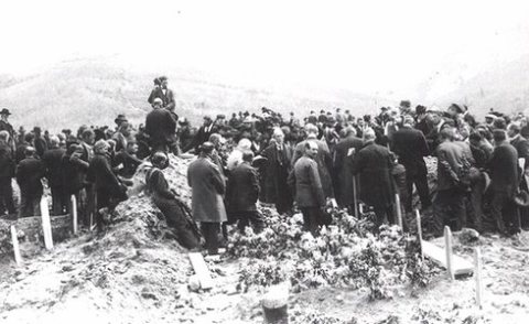
William Hirst, Justice of the Peace, acted as Coroner. The jury was composed of W. H. Potter, F. H. Mereweather. and A. Greenhalgh, who found a verdict as follows: State of Utah, County of Carbon, Precinct of Scofield. An inquest having been held in Scotield, in Scofield Precinct, Carbon County, State of Utah, on the 3rd day of May, 1900, before William Hirst, Justice of the Peace of Scofield Precinct, in said County.
Text read by machine from the scan; it may contain errors.
History of the Scofield mine disaster1900 · page 150Read the page →
Read the text
A number of its members had just formed an incorporation, the Fraternal Building Association of Scofield and Winter Quarters, and had completed arrangements to erect a handsome two story building-, half way between the railway station at Scofield and the company store at Winter Quarters, between which two points nearly all the cottages of the mine and railway employes are situated.
Text read by machine from the scan; it may contain errors.
Scans and text from the Internet Archive. Books published in 1930 or earlier, which are in the public domain.
Timeline
Scofield, 1879 to 1995
Woven from the archive, old maps, post office records, the National Register and the people born here.
Nothing in the archives for these yearsWeddings on Main Street, storms, parades, school pictures, the old store. If it’s in your family album, it belongs here.
Founding dates: Wikidata, Wikipedia, the U.S. post office records of Blevins & Helbock (CC0) and the Census. Homes by year built: Census ACS 2020–24. National Register of Historic Places: National Park Service (list of May 22, 2026). Old photos, postcards and papers: Wikimedia Commons, the Library of Congress and other public archives, credited on each item’s page. Maps: U.S. Geological Survey historical topographic maps (via Esri) and Sanborn fire-insurance maps (Library of Congress). History text and census tables: Wikipedia (CC BY-SA 4.0). Places that used to be: USGS Geographic Names Information System (2021). How TownRatings grades history →
From Wikimedia Commons (11), the Library of Congress (2), Wikipedia, U.S. Geological Survey historical maps, U.S. Census counts (via Wikipedia), the US Post Offices dataset (Blevins & Helbock), the USGS Geographic Names Information System, Sanborn fire insurance maps (Library of Congress) and old county and town histories (Internet Archive). Archive images are copied here with their credits and licenses, shown on each photo’s page. Refreshed monthly.


 1900
 1900
 1900
 1900
 1995
 Date?
 Date?
 Date?
 2016
 2016
 2010
