Walled Garden
Walled Garden lies 1.4 km southeast of Cheriton. It is looked after by the National Trust. Top of the 34 other places within 15 km is Winchester Cathedral, 11 km off.
Garden near Cheriton
Just outside Cheriton
Walled Garden is 1.4 km southeast of Cheriton. Towns near it ↓
Cared for by the National Trust
One of the places the National Trust looks after; members usually get in free. About ↓
Written from OpenStreetMap, Wikidata, the ONS built-up areas and Met Office 1991–2020 averages.
Weather through the year
For warmth, aim for May to September (17–22°C highs in Cheriton).
Walled Garden
It is run by National Trust.
- Type
- Garden
- Run by
- National Trust
- Town
- 1.4 km southeast of Cheriton
Practical details
- EntryA fee is charged
Its place on the map
Find Walled Garden in orange; each number is a place listed below.
© OpenStreetMap contributors · ONS built-up area 2022
Which towns are near Walled Garden
By population, New Alresford leads the 4 with 5,340. Each town here links to its own guide.
Cheriton
Bramdean
New Alresford
Bishop's Sutton
Compare the 4 towns
| Town | Where Walled Garden is | People | Places to visit |
|---|---|---|---|
| Cheriton | 1.4 km northwest of it | 358 | 4 |
| Bramdean | 1.5 km east of it | 269 | 2 |
| New Alresford | 3.9 km north of it | 5,340 | 4 |
| Bishop's Sutton | 4.3 km north of it | 415 | 2 |
Pair Walled Garden with these
A visit can add 3 historic houses, 2 castles and a cathedral, from 34 places within 15 km.
 CathedralWinchester Cathedral11 km away2
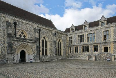 CastleWinchester Castle12 km away3
 Historic house · National TrustHinton Ampner100 m away4
 Castle · English HeritageWolvesey Castle11 km away5ChurchChurchOld Minster12 km away6
 ZooMarwell Zoo11 km away7
 Historic house · English HeritageThe Grange9.2 km away8
 Historic house · English HeritageBishop's Waltham Palace11 km away
Within 15 km, close and well known first. Numbers match the map.
Asked about Walled Garden
Where is Walled Garden?
Walled Garden is 1.4 km southeast of Cheriton, Hampshire.
What is Walled Garden?
Garden.
Who runs Walled Garden?
National Trust, so members usually get in free; check opening times before you go.
When is the best time to visit Walled Garden?
May to September are the warmest months in Cheriton, with afternoon highs of 17–22°C (Met Office 1991–2020 averages).
What else is there to see near Walled Garden?
Within 15 km: Winchester Cathedral (11 km), Winchester Castle (12 km), Hinton Ampner (100 m) and Wolvesey Castle (11 km).
Places: OpenStreetMap (© OpenStreetMap contributors, Open Database Licence) and Wikidata (CC0), placed in the ONS 2022 built-up area (Open Government Licence v3.0). Visitor counts are the latest Wikidata gives, with their year.
Photos: each place’s Wikidata image, from Wikimedia Commons under the licence below (our copy, resized).
Photo credits (7)
- Winchester Cathedral: http://www.wyrdlight.com Author: Antony McCallum, CC BY 3.0, Wikimedia Commons
- Winchester Castle: Martin Kraft, CC BY-SA 3.0, Wikimedia Commons
- Hinton Ampner: Rwendland, CC BY-SA 3.0, Wikimedia Commons
- Wolvesey Castle: Simon Burchell, CC BY-SA 4.0, Wikimedia Commons
- Marwell Zoo: User:Urshankov, CC BY-SA 4.0, Wikimedia Commons
- The Grange: Mpntod at English Wikipedia, CC BY-SA 2.5, Wikimedia Commons
- Bishop's Waltham Palace: Michael Coppins, CC BY-SA 4.0, Wikimedia Commons
Contains public sector information licensed under the Open Government Licence v3.0. Contains HM Land Registry data © Crown copyright and database right 2026. Contains OS data © Crown copyright and database right 2026 (ONS boundaries). Northern Ireland: Source: NISRA; contains Land & Property Services data and Ordnance Survey of Northern Ireland information, © Crown copyright, licensed under the Open Government Licence v3.0. Scotland: contains National Records of Scotland data, Registers of Scotland data and SEPA data, © Crown copyright / © SEPA 2025, licensed under the Open Government Licence v3.0.