
HMY Britannia
HMY Britannia is a 1953 royal yacht. It stands inside Edinburgh’s locality. The site is run by Royal Navy.
Museum in Edinburgh
One of the best-known places to visit in England, Scotland, Wales and Northern Ireland
#161 of the 8,556 museums, castles, gardens and other attractions we list, by how widely it is covered (23 Wikipedias). About ↓
Inside Edinburgh
HMY Britannia is inside Edinburgh’s locality, with 99 more places to visit within 5 km. Towns near it ↓
Written from OpenStreetMap, Wikidata, NRS’s localities and Met Office 1991–2020 averages.
Weather, month by month
In Edinburgh, June to August bring the warmest days: highs of 18–20°C.
HMY Britannia
23 Wikipedia editions have an article on it. A short trip away is Edinburgh Castle, 4 km off, the first of 165 within 15 km.
- Type
- Museum
- Run by
- Royal Navy
- Wikipedias
- Covered in 23 languages
- Town
- in Edinburgh
- Official site
- royalyachtbritannia.co.uk
The practical side
- EntryA fee is charged
The way to HMY Britannia
The numbers show what else is near HMY Britannia, in the order listed below.
© OpenStreetMap contributors · The dashed line is Edinburgh’s locality. · NRS locality 2022
Bases for a visit
Edinburgh is the biggest of the 8 bases nearby (493,794 people). The towns are in order of distance, its own town first.
Edinburgh
Danderhall
Musselburgh
Burntisland
Compare the 8 towns
| Town | Where HMY Britannia is | People | Places to visit |
|---|---|---|---|
| Edinburgh | It’s in town | 493,794 | 150 |
| Danderhall | 8.8 km southeast of it | 3,389 | 21 |
| Musselburgh | 9.2 km southeast of it | 21,476 | 21 |
| Burntisland | 9.7 km north of it | 6,259 | 9 |
| Kinghorn | 9.8 km north of it | 2,944 | 7 |
| Wallyford | 11 km southeast of it | 4,493 | 13 |
| Loanhead | 12 km south of it | 7,007 | 16 |
| Dalkeith | 12 km southeast of it | 15,125 | 18 |
While you are near HMY Britannia
Around it, within 15 km, lie 165 more, including 2 art galleries, a castle and a historic house.
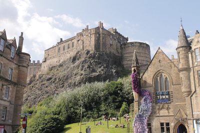 Castle · Historic Environment ScotlandEdinburgh Castle4 km away2
 Big drawArt galleryNational Gallery3.6 km away · 661K visitors a year (2021)3
 Historic housePalace of Holyroodhouse3.3 km away4
 MuseumNational Museum of Scotland4 km away5
 CathedralSt Giles' Cathedral3.7 km away6
 Art galleryScottish National Portrait Gallery3.1 km away · 313K visitors a year (2015)7
 Abbey or prioryHolyrood Abbey3.2 km away8
 GardenRoyal Botanic Garden Edinburgh2.7 km away
Within 15 km, close and well known first. Numbers match the map.
A visit to HMY Britannia: questions
Where is HMY Britannia?
HMY Britannia is in Edinburgh, City of Edinburgh, inside the town’s locality.
What is HMY Britannia?
1953 royal yacht.
Who runs HMY Britannia?
Royal Navy.
When is the best time to visit HMY Britannia?
June to August are the warmest months in Edinburgh, with afternoon highs of 18–20°C (Met Office 1991–2020 averages).
What else is there to see near HMY Britannia?
Within 15 km: Edinburgh Castle (4 km), National Gallery (3.6 km), Palace of Holyroodhouse (3.3 km) and National Museum of Scotland (4 km).
Places: OpenStreetMap (© OpenStreetMap contributors, Open Database Licence) and Wikidata (CC0), placed in the NRS 2022 locality (Open Government Licence v3.0). Visitor counts are the latest Wikidata gives, with their year.
Photos: each place’s Wikidata image, from Wikimedia Commons under the licence below (our copy, resized).
Photo credits (9)
- HMY Britannia: Akiramenai, Public domain, Wikimedia Commons
- Edinburgh Castle: Stephencdickson, CC BY-SA 4.0, Wikimedia Commons
- National Gallery: 瑞丽江的河水, CC BY-SA 4.0, Wikimedia Commons
- Palace of Holyroodhouse: 瑞丽江的河水, CC BY-SA 4.0, Wikimedia Commons
- National Museum of Scotland: Maccoinnich~commonswiki, CC BY-SA 3.0, Wikimedia Commons
- St Giles' Cathedral: 瑞丽江的河水, CC BY-SA 4.0, Wikimedia Commons
- Scottish National Portrait Gallery: Original uploader was Maccoinnich at en.wikipedia, CC BY-SA 3.0, Wikimedia Commons
- Holyrood Abbey: Enric, CC BY-SA 4.0, Wikimedia Commons
- Royal Botanic Garden Edinburgh: Steve nova at English Wikipedia., CC BY-SA 3.0, Wikimedia Commons
Contains public sector information licensed under the Open Government Licence v3.0. Contains HM Land Registry data © Crown copyright and database right 2026. Contains OS data © Crown copyright and database right 2026 (ONS boundaries). Northern Ireland: Source: NISRA; contains Land & Property Services data and Ordnance Survey of Northern Ireland information, © Crown copyright, licensed under the Open Government Licence v3.0. Scotland: contains National Records of Scotland data, Registers of Scotland data and SEPA data, © Crown copyright / © SEPA 2025, licensed under the Open Government Licence v3.0.