Bodiam Boating Station
Head 1 km northeast of Northiam for Bodiam Boating Station, an attraction. A short trip away is Bodiam Castle, 5.2 km off, the first of 30 within 15 km.
Attraction near Northiam
Just outside Northiam
Bodiam Boating Station is 1 km northeast of Northiam. Towns near it ↓
Written from OpenStreetMap, Wikidata, the ONS built-up areas and Met Office 1991–2020 averages.
Weather by the month
May to September are the warmest in Northiam, with afternoon highs of 18–23°C.
Bodiam Boating Station
Attraction.
- Type
- Attraction
- Town
- 1 km northeast of Northiam
- Official site
- bodiamboatingstation.co.uk
Around Bodiam Boating Station, mapped
The map puts Bodiam Boating Station in orange and numbers its neighbours as in the list.
© OpenStreetMap contributors · ONS built-up area 2022
The towns around Bodiam Boating Station
Among the 6, Northiam is the biggest, home to 1,910 people. The list runs from its own town outward.
Northiam
Linkhill
Rolvenden Layne
Sandhurst
Also within reach
The 30 places within 15 km include 2 castles, 2 gardens and 2 historic houses.
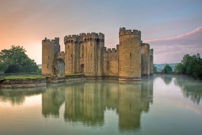 Castle · National TrustBodiam Castle5.2 km away2
 Garden · National TrustSissinghurst Castle and Garden12 km away3
 Abbey or priory · English HeritageBattle Abbey14 km away4
 GardenGreat Dixter2.5 km away5
 Castle · English HeritageCamber Castle12 km away6
 Historic house · National TrustLamb House11 km away7Heritage railwayHeritage railwayKent and East Sussex Railway7.9 km away8
 Historic house · National TrustSmallhythe Place6.5 km away
Within 15 km, close and well known first. Numbers match the map.
Questions about Bodiam Boating Station
Where is Bodiam Boating Station?
Bodiam Boating Station is 1 km northeast of Northiam, East Sussex.
What is Bodiam Boating Station?
Attraction.
When is the best time to visit Bodiam Boating Station?
May to September are the warmest months in Northiam, with afternoon highs of 18–23°C (Met Office 1991–2020 averages).
What else is there to see near Bodiam Boating Station?
Within 15 km: Bodiam Castle (5.2 km), Sissinghurst Castle and Garden (12 km), Battle Abbey (14 km) and Great Dixter (2.5 km).
Places: OpenStreetMap (© OpenStreetMap contributors, Open Database Licence) and Wikidata (CC0), placed in the ONS 2022 built-up area (Open Government Licence v3.0). Visitor counts are the latest Wikidata gives, with their year.
Photos: each place’s Wikidata image, from Wikimedia Commons under the licence below (our copy, resized).
Photo credits (7)
- Bodiam Castle: Antony McCallum, CC BY-SA 3.0, Wikimedia Commons
- Sissinghurst Castle and Garden: Hans Bernhard (Schnobby), CC BY-SA 3.0, Wikimedia Commons
- Battle Abbey: Antony McCallum, CC BY-SA 3.0, Wikimedia Commons
- Great Dixter: Miles Berry, CC BY-SA 2.0, Wikimedia Commons
- Camber Castle: Oast House Archive, CC BY-SA 2.0, Wikimedia Commons
- Lamb House: Elizabeth B. Thomsen, CC BY-SA 2.0, Wikimedia Commons
- Smallhythe Place: Tony Hisgett from Birmingham, UK, CC BY 2.0, Wikimedia Commons
Contains public sector information licensed under the Open Government Licence v3.0. Contains HM Land Registry data © Crown copyright and database right 2026. Contains OS data © Crown copyright and database right 2026 (ONS boundaries). Northern Ireland: Source: NISRA; contains Land & Property Services data and Ordnance Survey of Northern Ireland information, © Crown copyright, licensed under the Open Government Licence v3.0. Scotland: contains National Records of Scotland data, Registers of Scotland data and SEPA data, © Crown copyright / © SEPA 2025, licensed under the Open Government Licence v3.0.