The Howard post office opened in 1881, the earliest record of the town by name. Another post office, Longley (1880), opened inside today’s city and later closed.
First census: 588 in 19002020 census: 848145 years
Founding year: the first Howard post office (Blevins & Helbock, CC0).The full story ↓
What stands out about Howard’s past
Read from the archive, the National Register and the record. The page puts what stands out first.
Fire insurance maps drew every building, what it was made of and what it was used for, so insurers could price the risk of fire. Pick a year, then a sheet.
1886Sheet 1 of 1
Edition
Sheets
BrickWoodStone
Sanborn Map Company, via the Library of Congress. Editions published in 1930 or earlier, which are in the public domain.
People over time
Howard, census by census
Peaked at 1,325 in 1920; 848 people lived here in 2020.
13 censuses, 1900–2020.
U.S. Census Bureau decennial counts, from the census table on Howard’s Wikipedia page.
The city of Howard was established in 1881, shortly after the Southern Minnesota Railway was extended to that point. The city was named for Howard Farmer, the son of the townsite owner, J. D. Farmer. In 1883, when Miner and Sanborn counties were organized, the town was named the county seat of Miner County.
One of the first known photographs of a tornado is an image of the 1884 Howard, South Dakota, tornado.
The first public library in Dakota Territory was the Howard Public Library, chartered in 1886.
Howard became the first municipality in South Dakota to own and operate its own wind turbines in 2001.
Since 2001, over 200 new jobs have been created in the community. From 1996 to 2008, the city's sales tax revenues increased 123%.
Nothing in the archives for these yearsWeddings on Main Street, storms, parades, school pictures, the old store. If it’s in your family album, it belongs here.
Founding dates: Wikidata, Wikipedia, the U.S. post office records of Blevins & Helbock (CC0) and the Census. Homes by year built: Census ACS 2020–24. National Register of Historic Places: National Park Service (list of May 22, 2026). Old photos, postcards and papers: Wikimedia Commons, the Library of Congress and other public archives, credited on each item’s page. Maps: U.S. Geological Survey historical topographic maps (via Esri) and Sanborn fire-insurance maps (Library of Congress). History text and census tables: Wikipedia (CC BY-SA 4.0). Places that used to be: USGS Geographic Names Information System (2021). How TownRatings grades history →
From Wikimedia Commons (3), Wikipedia, Wikidata and Wikipedia for famous people, U.S. Geological Survey historical maps, U.S. Census counts (via Wikipedia), the US Post Offices dataset (Blevins & Helbock), the USGS Geographic Names Information System and Sanborn fire insurance maps (Library of Congress). Archive images are copied here with their credits and licenses, shown on each photo’s page. Refreshed monthly.


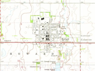
 2012
 2004

