Wikipedia doesn’t have a history of Pomeroy yet. The photos, dates and memories neighbors add here are how it gets written.
Pomeroy is a census-designated place (CDP) in Sadsbury Township, Chester County, Pennsylvania, United States. The population was 401 at the 2010 census. It was once the northern terminus of the Pomeroy and Newark Railroad until passenger service was terminated in 1928.
Its first post office opened in 1866. Between the 2010 and 2020 censuses its population grew from 401 to 1,085 (+171%).
Intro from Wikipedia. Population: U.S. Census Bureau.
From the old history books
What they wrote about Pomeroy in 1881
Passages that mention Pomeroy, cut from the printed page as they were published.
History of Chester County, Pennsylvania, with genealogical and biographical sketches1881 · page 362Read the page →
Read the text
This was incorporated March 24, 1868, under the name of the Doe Run and White Clay Creek Railroad, to extend from the Pennsylvania Railroad at Pomeroy to the Delaware State line, and there connect with another road running to Delaware City. The name was subsequently changed to the present title, and in 1873 the road was leased by the Pennsylvania Railroad Company, by which it is now operated. It connects with the Baltimore Central
Text read by machine from the scan; it may contain errors.
Scans and text from the Internet Archive. Books published in 1930 or earlier, which are in the public domain.
By decade
Pomeroy, decade by decade
One decade in the archive so far: the 1920s. Scroll each row; tap a photo for its story.
Nothing in the archives for these yearsWeddings on Main Street, storms, parades, school pictures, the old store. If it’s in your family album, it belongs here.
Founding dates: Wikidata, Wikipedia, the U.S. post office records of Blevins & Helbock (CC0) and the Census. Homes by year built: Census ACS 2020–24. National Register of Historic Places: National Park Service (list of May 22, 2026). Old photos, postcards and papers: Wikimedia Commons, the Library of Congress and other public archives, credited on each item’s page. Maps: U.S. Geological Survey historical topographic maps (via Esri) and Sanborn fire-insurance maps (Library of Congress). History text and census tables: Wikipedia (CC BY-SA 4.0). Places that used to be: USGS Geographic Names Information System (2021). How TownRatings grades history →
From Wikimedia Commons (6) and old county and town histories (Internet Archive). Archive images are copied here with their credits and licenses, shown on each photo’s page. Refreshed monthly.


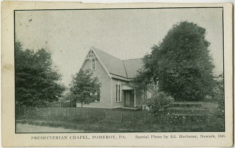 1923
 2022
 2022
 2022
 2022
 2022


